
|
|
Mountain/Rock |
|---|---|
|
|
40.26100°N / 5.1811°W |
|
|
Hiking, Mountaineering, Scrambling |
|
|
Spring, Summer, Fall, Winter |
|
|
7680 ft / 2341 m |
|
|
Page optimized for a screen resolution of 1280 x 1024 pixels
Overview
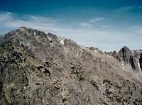
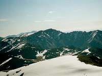 La Mira seen from the west
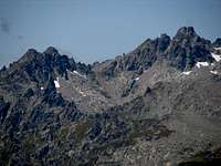 Circo de Gredos seen from La Mira
 Galayos from La Mira summit
La Mira (2,341 ms) stands in the divide of Sistema Central, in the province of Ávila (Spain). It is the highest and famous peak of the monotonous and width divide between Circo de Gredos and Puerto del Pico. It is easy to climb, stands in a suggestif environment, has good views from summit and is frequented by many ibex attracted by a spring in the north slope, near summit. As a result, is one of the most visited peaks of Gredos, specially by Garganta de la Apretura route where, somedays in spring and summer you can see a real parade.
Seeying its name, we can think that this is a good viewpoint… and we don’t mistake. In the following link, you can find a 360º interactive panoramic view from summit. For that reason, this peak was chosen to place, late in the XVIII century, an optical telegraph in its summit. Nowadays, still remains the cylindrical platform on which the device was settled. Well, this is the true history; people is imaginative and sometimes I have heard (an readed too) that it is a medieval sentry tower; even a Roman remain.
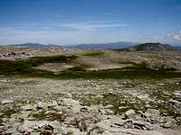
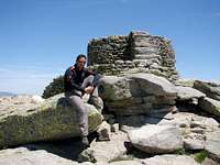 La Mira summit
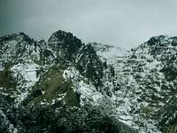 La Mira seen from the south
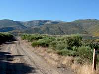 La Mira seen from the north
This mountain has two many differents faces. The northern slope is soft, with long and width throats of moderate steep, between rounded hills. In contrast, to the south, La Mira is on top of an abrupt, high and very steep rocky slope, that projects several ridges full of needles; among them, Los Galayos is the most famous but not the only one. Despite the proximity of so vertiginous places, La Mira itself offers little chances for difficult climbing and the most of the routes to summit consists in more or less long walks without further complication which we want.
 Sketch of La Mira area
Getting There
 La Mira seen from Peña del Mediodía
Depending from which side you want to climb La Mira, you must first go to one of these two towns.
- North: Hoyos del Espino, 175 km away from Madrid. There is bus service from Madrid or Ávila; the company is CEVESA, phone 00 34 91 539 31 32.
- South: Arenas de San Pedro, 170 km away from Madrid. There is bus service from Madrid or Ávila and you can find information about in the website of the Arenas de San Pedro town council.
In these two towns, there are shops, hotels, banks, etc. and bases of ascent are between 5 and 15 km away, without other option to go on that a taxi or to walk. For that, the most advisable mean to get there is by car. You can see the most convenient route from your point of departure in the Michelin website.
Red Tape
No one in general. To do fire (in any form) is forbidden during the summer (july to mid-september) in woods.In the north side, the route of Garganta de la Covacha pass through private lands. Passing by foot or even camp one night is tolerated but owners are not obliged to.
To park in La Plataforma (base for routes from the west) is restricted in weekends and not free. There is a bus service from Hoyos del Espino. Conditions can change but, in 2012 you can find fees for parking and bus in this link.
Camping and Huts
 La Mira seen from the southwest
North side:
Refugio de Reguero Llano, a served hut near La Plataforma, one of the bases of ascent to La Mira, 12 km away from Hoyos del Espino. There are 20 places to stay and foods are served. It’s open in week-ends and holidays almost all the year except, in winter, if conditions are very bad. A previous call is always advisable, for its reduced capacity. Phone numbers: (00 34) 689 412 639 / 659 378 995.
Camping in Hoyos del Espino, 2 or 3 km away from town, towards La Plataforma. Its website is www.campingredos.com.
South side:
 Hut in Nogal del Barranco
Refugio Victory, a served hut in Los Galayos (see this area page in parent objects). It has 16 places (but I can say that, if needed, more than double can be inside) and the only service offered is drink sale. There aren't blankets or any other comforts but it is clean, you will have a roof over your head and is cheap (5€ a night). It’s open from June 15th to September 15th and week-ends the rest of the year.
There are a free hut in Mingo Fernando (4 places, without commodities but clean). You can find some photos and a more accurate descripciton (in spanish) in this link.
Another free hut is in Nogal del Barranco; it’s usually closed and keys are in the forest ranger’s house in Guisando, a little village between Arenas de San Pedro and the usual bases of ascent, 5 km away from town. It has 12 places, without commodities.
Camping in Guisando. Phone number: (00 34) 920 374 021.
Most Common Routes
 La Mira seen from El Raso
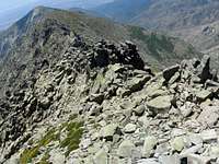 Northwest ridge
- From La Plataforma, by western ridge. Elevation gain, 750 ms. Hiking by trails.
- By Garganta de los Conventos. 900 ms. Hiking.
- From Mingo Fernando, by Canal Seca. 1,150 ms. UIAA F (YDS Class 4)
- From Nogal del Barranco, by La Apretura. 1,250 ms. Hiking.
- NW ridge from El Raso. UIAA AD-, max III (YDS 5.3) for 2 hours.
When to Climb
 Spring near the summit
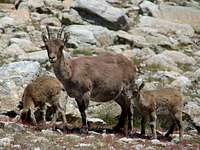 Ibex in La Mira
All the year, with the following cares:
- Snow persist usually untill early may and appears irregularly some time between october and january. A strong snowfall that persist only a few days is possible one moth before of after these periods. When snow is abundant, small avalanches are possible in Garganta de la Apretura highest section. The others routes haven't this problem.
- In summer, it could be very hot and springs are sometimes dryed. Take it in account.
Other Practical Infos
For local weather forecast, visit the webpage of AEMET (Spanish government weather agency).Cartography:
Editorial Alpina, sheet "Sierra de Gredos", 1:40,000.
Editorial Adrados, sheet "La Sierra de Gredos", 1:25,000.