Overview
This is a collection of Mountain Lakes in the Wasatch Mountains.
Feel Free to add any of your photos to this album as long as the Lake is in the Wasatch Mountains. I'll make a list of lake underneath and will keep adding to them as you people post different lakes that you want added to this album.
There is also another page that only goes through the lakes of the Central Wasatch.
click here to see the page.
Lake Blanche, Lake Lillian and Lake Florence
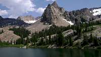
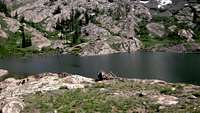
Lake Blanche, Lake Florence, and Lake Lillian sit in a bowl below some of the highest peaks in the Wasatch. Smooth Glacier carved Quartzite rocks surround the lake. These impressive rocks were carved by a massive Glacier that melted thousand of years ago.
How To Get There: Drive to Big Cottonwood Canyon from Salt Lake City by taking I-215 to the 6200 South "Canyons" exit and then continue east on U-152 following the sings of Solitude and Brighton. Go for about 4 miles from the mouth of the canyon and before you reach the famous "S turn," turn into the parking lot on the right side. On weekends there will be cars parked outside the parking lot, this means you should park outside as well. Hike up the paved road from there until you reach a dirt trail. That is the Lake Blanche Trail.
For a nice and fully detailed page
Click Here
Trail info:
Mill B South Trailhead
Distance: 2 3/4 miles
Elevation gain: 2720 ft
Time: 1-4 hours.
![Lake Blanche]() Lake Blanche from the east
Lake Blanche from the east![Lake Blanche]() Lake Blanche from the west
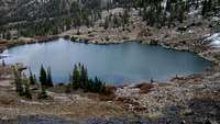
Lake Blanche from the west![Lake Florence and Lake Lillian]() Lake Florence and Lake Lillian (farther one)
Lake Florence and Lake Lillian (farther one)![Lake Florence]() Lake Florence
Lake Florence![Lake Lillian]() Lake Lillian
Lake Lillian![Lake Florence and Lillian]() Lake Florence and Lillian
Lake Florence and LillianSecret (cecret) Lake
Secret (Cecret) Lake is a very beautiful lake set in Albion Basin with a spectacular view of Sugarloaf mountain, and Devil's castle towering above.
It can be spelled either Secret or Cecret.
How To Get There: Take the 6200 South "Canyons" exit from I-215 and continue east to the canyon on U-210 following signs for Snowbird and Alta
Keep traveling up the canyon road until you reach the Service Road or Dirt
road. Go about 4 miles up the Dirt Road and you'll reach the trail head. If the road splits up, keep going right.
Trail Info:
Albion Basin Trailhead
Distance: .50 miles
elevation gain: 400 ft.
Time: 10-30 minutes
![Secret (cecret) Lake]() Secret Lake from the West
Secret Lake from the West![Cecret Lake]() Cecert Lake
Cecert LakeLower Bells Reservoir
Although it might not be a lake, It looks like one. This is called The Lower Bells Reservoir, and the "Lower" means that there is also and "Upper" Bells Reservoir as well. A reservoir is usually a Man Made lake in which water is stored throughout the winter and when it melts, it is sent down to the city. In this case, this reservoir is part of Sandy City, so It's water goes to sandy city.
How To Get There: there are three Trailheads for this particular canyon, but one is no longer in use due to the building of private property.
To see a detailed page
Click Here
Trail Info:
Trail 1
Distance: 1 mile
Elevation: 500 ft
Time: 15-45 Minutes
Trail 2
Distance: 1/2 Mile
Elevation: 500 ft
Time: 20-50 Minutes
First and Second Waterfalls in Bells Canyon
Here is some really good information that Spengy here on SP gave me about the two major waterfalls in Bells Canyon.
First Falls
Position: 40.560 -111.770 @ ~6720 feet (WGS84 datum)
Distance from trailhead: ~2 miles (so 1.5 miles from the lower reservoir)
Elevation gain from trailhead: ~1500 feet
Note that the position I have given is actually where the trail splits (to the north) to head for the waterfall. The waterfall is about 3-5 minutes from here. I gave this position because people (my brother ) have been known to miss the fork.
Second Falls
Position: 40.558 -111.761 @ ~7500 feet (WGS84 datum)
Distance from trailhead: ~2.6 miles (so 2 miles from the lower reservoir)
Elevation gain from trailhead: ~2300 feet
Note that there are many waterfalls in bells canyon of varying shapes and sizes... In my opinion this is the second major waterfall... There may be a couple smaller ones between that first one and this one.
Map
Here is a ghetto map I made using Google Earth
Upper Bells Reservoir
Brighton Lakes
The area above Brighton Ski resort contains 7 lakes. These lakes are very scenic and are all relatively short hikes.
Silver Lake : Drive all the way down Big Cottonwood canyon until you reach Brighton and you'll find Silver Lake. Silver Lake is not even considered an actual hike by many, but there is a board-walk that goes all the way around the lake.
Lake Solitude : While at Silver Lake, if your looking for an adventure, you can head up to Lake Solitude. The Lake Solitude trail begins at the North-East corner of Silver Lake. The trail then splits, the one going straight goes to Lake Solitude. Distance is 1 mile with
Comments
No comments posted yet.