
-
 26151 Hits
-
 84.27% Score
-
 18 Votes
|
|
Mountain/Rock |
|---|---|
|
|
48.13030°N / 121.67°W |
|
|
5688 ft / 1734 m |
|
|
Overview
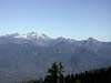
Liberty Mountain is located approximately three miles directly south of Three Fingers and stands as another prominent peak on the far western flank of the Cascades, along with Whitehorse, Three Fingers, and Pilchuck. There are a few different routes, although all are thickly covered in timber and brush and have long approaches. There are no trails or climbers' paths, so access is a lot of work. Be prepared to face LOTS of devil's club if you go in the summer.
Getting There
The approach varies on which route you decide to climb. The standard approach for the southwest ridge route (referenced in the Beckey guide)was to take FS Road 4111 to Canyon Lake, however a road washout has added a couple miles of road hiking onto this approach. I approached via the old FS Rd #4131 on bicycle/bushwhacking. This road is very rough and may be accessible for a short distance with a high-clearance 4WD vehicle, until a huge washout that completely demolished the road.Follow SR-92 east to Granite Falls, turn onto the Mountain Loop Hwy and continue east for about 6-7 miles and turn left (north) on Tupso Pass Rd (FS Rd #41). You have two choices from here:
1. When the pavement ends, turn right onto Rd 4110 and follow for a mile or two and turn right onto FS Rd 4111 and follow this as far as you can.
2. When the pavement ends, continue up the hill to the left. Follow this road for about 6 miles, you will go around a sharp hairpin turn to the left over a creek where the road will noticeably dip down. Soon after you will see a road fork uphill to the right. Park here or keep driving if you are brave! This is Road #4130, which later branches into 4130 and 4131.
The Beckey guide also mentions a possible approach for the southeast ridge via the Marten Creek trail or Copper Creek Rd from the Darrington side.
(see Cascade Alpine Guide: Stevens Pass to Rainy Pass by Fred Beckey)
 |  |  |
Red Tape
Northwest Forest Pass required if you park at a trailhead, otherwise no permits.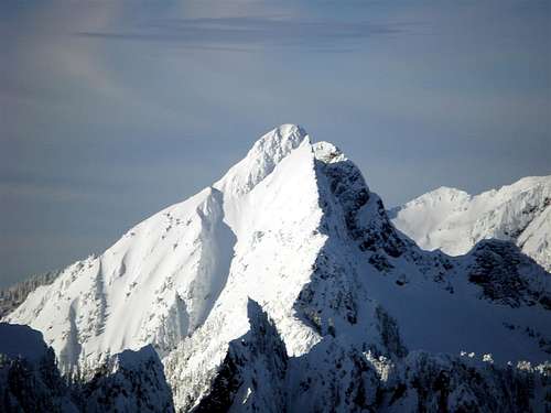
When To Climb
Approach is difficult any time of year because of very thick timber and brush, some upper portions may be easier in early season when snow cover can make travel easier, however access would be even longer with substantial snow (you would be snowshoeing instead of driving or biking).Camping
As far as I know, permits are not required for backcountry camping. Contact Verlot Ranger Station for more info. Not many places to set up a tent in the area anyways. Camping near the mountain, your best bet would be low on the east side of Canyon Creek amongst the old growth trees. Steep country and very thick brush will prevent you from camping anywhere else - trust me! (unless you have a very small tent or bivy).Mountain Conditions
Verlot Ranger Station(360) 691-7791
Northwest Weather and Avalanche Center
http://www.nwac.noaa.gov/
 |  |  |
Schmitz - Mar 26, 2005 2:51 pm - Hasn't voted
Untitled Commentwhen you approach the lake, the road forks. Do NOT take the right fork that heads downward, take the left fork and follow it even if it looks worse. I had experienced this first hand.
kevinsa - Jan 29, 2015 9:37 pm - Hasn't voted
FR4131Both FR4130 and FR4131 are now almost completely brush free due to road decommissioning work done by Forest Service contractors in 2014. Numerous 'tank traps' make the road unsuitable for mountain bikes. If you have any interest in climbing Big Bear, Liberty, or Fletcher, the next few years will be a great opportunity to do so.