
-
 9535 Hits
-
 93.35% Score
-
 42 Votes
|
|
Mountain/Rock |
|---|---|
|
|
46.30450°N / 13.63169°E |
|
|
Hiking, Scrambling |
|
|
Summer, Fall |
|
|
6135 ft / 1870 m |
|
|
Overview
"The Macchu Picchu" of Julian Alps

The view on Krn

Lipnik neighbours
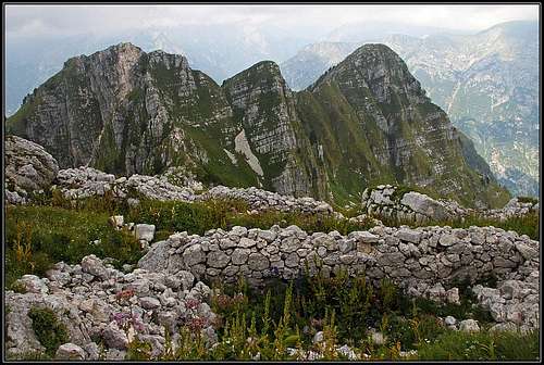
It certainly is worth of a visit, this Lipnik, especially if you know some of its stories. It's a completely abandoned area - was all the time in the past and is today. But there was a small window in time, when crowds of people were running along its slopes. The World War I. Today it's hard to believe, but just below the summit of Lipnik, there was a whole military village. If Julian Alps should nominate its candidate for "Macchu Picchu", Lipnik is certainly the first candidate.The ruins, steep, grassy mountains behind, everything fits. Only the story is different...
Today only special kinds of enthusiasts visit Lipnik and the neighbourhood. In the first place those are explorers of the World War I events and legacy. They want to know every trench, every heavy gun post and every shelter from those times. Secondly, weird hikers might ascend there, searching for solitude, nice views and especially if they know something about the events which happened there. And it's more or less all, if you don't take into consideration hunters who know every corner of their mountains. And are hard to reveal their secrets. Otherwise locals moved almost completely out of these mountains. Alpine pastures are empty, shepherds huts decayed almost completely. In addition to historical memories, a special reward is also the panorama from Lipnik. Most beautiful are the views of high Julian Alps summits across Soča valley, but also the nearby views on the summits of Krn group are nice and unusual.
A Brief Geographical Outline
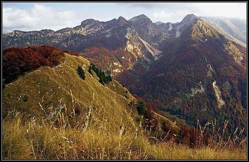
Lipnik group from the summit of Javoršček
From the summit of Krn a strong ridge is stretching towards the N-NW. On a first look it seems that only a single chain of summits is descending towards the banks of Soča river. But there is a small break in it. After the summit of Vršič, 1897 m, the ridge continues more in the NW direction, but soon ends in a side branch (Kal, 1600 m). North of Vršič there is a high valley, called Dolič, culminating with a nameless saddle. And only beyond this valley and saddle the main mountain chain resumes again. So, the summits of Lipnik, 1870 m, Srednja Špica, 1819 m, Hudi vrh, 1808 m, and further on Vršiči, 1699 m, are forming its own small group, where Lipnik is the highest summit. From Srednja špica another side ridge branches towards the west, culminating with the summit of Javoršček, 1557 m, which is so nicely seen from the town of Bovec. We shall see later how this configuration impacted the positions during the World War I.
On the east and north these mountains are falling down to Lepena and Soča valley. South of Javoršček there is the deep valley of Slatenik creek, and, as we know from the general description of Krn group, west and north-west of the highest summit there's a terrace of alpine pastures, which can be reached by a narrow mountain road. North of Čez Utro saddle, 1317 m, which separates Javoršček from the rest of the group, there is Golobar alpine meadow. Although it is abandoned today, Golobar is a very important place where tours on the nearby summits start. The meadow has a rich history and can be reached by a good, nowadays marked military mule track, which of course follows the old shepherds path. The eastern slopes above Lepena valley were once also passable by military paths, which are today more and more lost in wilderness. And the only alpine meadow there, Zagreben, is abandoned too (except a hunters hut).
Getting There

Soča near the trailhead
The most recommended approach on Lipnik summit is over Golobar meadow. That means starting in the valley of Soča, near the village of Kal-Koritnica (marks start at a monument, by the main road). See the main page of Krn group how to get into the valley of Soča and Bovec town.
The second possible trailhead is the village of Čezsoča, which can be quickly reached from Bovec, crossing the river of Soča. There the marked path through Slatenik valley starts and the road a bit higher on the NW slope of Javoršček goes. From that road, Golobar can also be reached.
Even shorter is the approach from the alpine meadows below Krn summit. But driving up takes you quite some time. You leave the valley of Soča in Kobarid, drive up to Drežnica village and then further on to Drežniške Ravne and Zapleč alpine meadow, 1208 m. There the road is closed for public traffic and you continue horizontally on Predolina meadow, where a real hike starts. 2021 info: The path, leading from Predolina across the slopes of Kal towards Dolič and Golobar meadow is in the middle ruined by landslide and not passable!
And the last, but least recommendable starting point for a tour on Lipnik is the valley of Lepena. Just close to the inflow of Lepenjica creek into Soča river there is a starting point of two military paths, which are today very decayed.
World War I On Lipnik

Memorial cross
On the mountains of Krn group the frontline soon settled down and despite fierce fightings didn't move much till the final break in 1917. The Italian army was holding the whole ridge, coming here from the summit of Krn, over Krnčica, Vršič to the final outpost of Kal. But just below the summit of Kal there were already Austro-Hungarian positions. Austrians were attempting often to take Kal, there were many casualties, also from the mine war and avalanches. On the other side of Dolič valley there were strong Austro-Hungarian fortifications - on the whole ridge from Javoršček to Lipnik you can still today see their trenches, caverns, heavy gun posts and similar. As said, on the summit of Lipnik there was a whole military village, where soldiers stayed permanently. And the positions were supplied from Golobar meadow and Lepena valley, so over the slopes which were safe from Italian gun shelling. In Dolič valley, there was also a graveyard and a small chapel, of which you can today see only a few steps. At that time the whole valley was called Kapellental (=Chapel Valley). Even if it was on the open terrain it was never shelled by Italian heavy guns. Today along many remarkable places from the WW1 a memorial trail goes. It is named "Poti miru" ("Trails of Peace", "Wege des Friedens", "Le vie della pace"). Also on the way to Lipnik you will see its marks. In our region the path goes from Kal-Koritnica, over Golobar meadow, Čez Utro pass, Dolič Predolina and further around Krn. Here's the link to the foundation.

|
My wife's grandfather, who was "Oberleutenant" in Austro-Hungarian army, spent autumn and winter 1915/16 on Golobar meadow and the neighbouring frontline. When he arrived on Golobar with his "7th Companie", they had no shelter, so he drew plans for different kinds of barracks, the soldiers built them and he took photographs of them. During 4 years of WW1 he was daily writing a diary and Jasmina collected all texts and photographs and published them in a book. Together with other testimonies it was also a subject of a TV movie in which Jasmina was casting on Golobar. That was the first time when we went there and where experts told us many stories of the WW1 time. It was really touching to stand on the place where today only a big stone cross stands and look on Jasmina's grandfather's pictures, taken by the same rock. His barrack was standing just next to the rock (the cross was erected a few months later). |
Golobar Victims During the World War II
A nasty betrayal caused in April 1943 a tragedy on Golobar meadow. By a high command three bataillons of partisans should gather on Golobar meadow to form new brigades. Fortunately many groups couldn't cross the river of Soča, which was very high at that time. Still, four squadrons came and were soon surrounded by close to 500 Italian soldiers who were informed about the gathering. In an unequal fight more than 40 partisans were killed, while Italians had only 4 dead. The majority of partisans still succeeded with the breakthrough.
Routes Overview
|
Unless you know the area really well, only one ascent route can be recommended. Yet, there is more than one variant to reach Golobar meadow, so you might also combine tours in the lower part. 1. From Golobar meadow. Golobar can be reached by two marked paths and at least three unmarked paths. See the route description for more details. The usual ascent from Kal-Koritnica takes you some 2 hours. From the cross on the upper part of the meadow continue by a good military mule-track towards the SE. After 30 minutes deter left and ascend the notch between Srednja špica and Hudi vrh. Then cross the slopes of Srednja špica on the eastern side and go by the ridge on top. Less than 2 hours from Golobar, not marked, below good mule-tracks, above a narrow path across steep grassy slopes. The other two possible ascents are only for those who want to experience Lipnik from all sides. The most adventurous might still combine routes in order not to descend by the same one. 2. From Lepena side (I haven't done the route). On the Golobar route page the Bulfon Weg was already mentioned, starting near the confluence of Lepenjica and Soča. The other military path, going across the slopes on Lepena side also starts there. It is (was) called Primus Weg. After a few turns going jointly, Primus Weg continues towards the south and soon reaches ex Zaslape meadow (this meadow can be also reached directly up from Lepena valley). The continuation of the trail is very hard to follow. The direction is southwards, the paths once continuously crossed the slopes of Vršiči, Hudi vrh, finally bringing you below the notch between Hudi vrh and Srednja špica. Even if you find the path below, above it gets lost, but a steep, not really dangerous terrain will bring you on the lower part of Lipnik summit slopes. Even if this is the most direct approach, you'll need more than 4 hours. |
3. The direct approach from Dolič valley is the last possibility (I haven't done the route). See the Golobar route description to learn how to reach Dolič (approaches #2 and #3). If you are coming from Predolina or through Slatenik valley, you might negotiate the direct ascent. There are reports that after ascending through Dolič some 30 minutes, you can turn left (in the E direction) and ascend over the steep grassy slope, falling down from the ridge between Srednja špica and Lipnik. You keep right of a big rockslide, which happened in the last earthquake. The ascent is very steep, no trail at all, can be tried only when grassy slopes are dry. Some 500 meters of such a terrain, from the remains of the chapel in the lower Dolič some 2 hours. The bottom of this slope could also be reached by crossing from Zagreben meadow (unmarked path from Lepena till there), reaching the unnamed saddle on top of Dolič and descending from that saddle accordingly.
4. The ascent on Srednja špica. Today, that summit shows deep wounds from the last earthquake. Rockslide went down almost from its top. From the notch and the path on Lipnik you can see caverns in its slope, but the ascent on top must have been very steep. Unfortunately I have no more information.
5. The ascent on Hudi vrh. From the notch, where the Lipnik path comes, you deter left and ascend the summit by the connecting ridge. Steep grassy slopes!
6. The ascent on Javoršček. From Čez Utro pass you simply continue westwards. Even if also Javoršček was heavilly fortified, today the paths are almost lost, but keeping close to the ridge (the open S slope) you can not miss the highest point. Steep terrain, some care is needed.
Maps
- Most of the area is well covered on: Jalovec in Mangart, 1:25.000. Planinska zveza Slovenije.
- The area a bit south of Lipnik is covered on: Krn, 1:25.000. Planinska zveza Slovenije.
Mountain Huts and Camping
In this area there are no official mountain huts. If hitting hunters huts, you will find them locked. The ruine below Golobar (1000 m) is hardly usable, perhaps only in emergency. Setting up a tent on Golobar over night would probably pose no problem, because nobody comes there, but the tour can anyway be done in one day (some 7-8 hours of walk). I also have in my subconsciousness that a few years ago it was heard that on Golobar meadow a bear family was "living" (they usually only pass by). And when Jasmina ascended once around Javoršček, she found a wet place with many traces of wild boars. But also those smart animals almost allways avoid people.
When To Climb?
The best months are in summer and autumn, somewhere between June and October. Due to steep grassy slopes a winter ascent would require very good conditions - hard snow. I also don't know anyone who would do skiing there. And to be more precise, if you want to see most of the WW1 relics, it is good to arrive when vegetation is not abundant, so in late spring and late autumn.
External Links
- Pro Hereditate - A very rich site with a lot of information about the World War I on "Soška fronta" (Soča frontline).
- "Pot miru" - "The Walks of peace" fundation web page.