
|
|
List |
|---|---|
|
|
OVERVIEW
There are county highpointers.There are prominence seekers.
And then there are the truly dedicated, some might say quirky, peakbaggers who seek the most prominent point in every county.
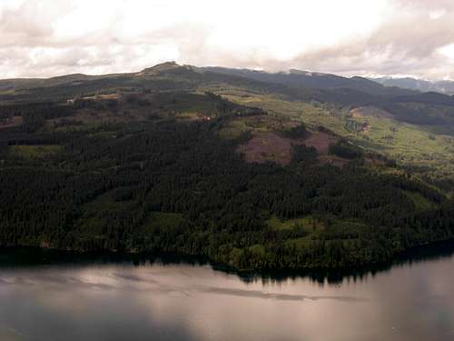
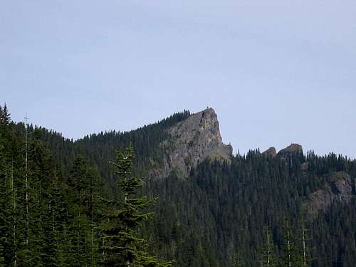 High Rock, Greatest Prominence Point Of Lewis County
Just as every county has a highest point, every county also has a most prominent point. The most prominent point in a county is perhaps most accurately referred to as the CoGPP (County's Greatest Prominence Point), but is also referred to by some peakbaggers as the county prominence point or county "prom" point. Occasionally a location might meet criteria of being both a county's highest point and greatest prominence point, but many times that does not happen.
 Mount Olympus, Jefferson County Highpoint And CoGPP
Such is the case in Washington, where many of the greatest prominence points are not the same as the actual highpoints within those counties. In fact, 20 out of Washington's 39 counties, or over 50% of them, have different greatest prominence points than county highpoints.
 Weatherwax Ridge, Greatest Prominence Point Of Grays Harbor County
This peakbagging category is so obscure, in fact, that this is the first SummitPost page completely dedicated to listing all CoGPPs within a specific State.
 Mount Washington, Greatest Prominence Point Of Mason County
For information regarding Washington's County Highpoints, click here.
THE LIST
| COUNTY | MOST PROMINENT POINT | PROMINENCE | ELEVATION | ALSO THE CoHP? | GPS COORDINATES (Dec Deg) |
| ADAMS | TAUNTON BENCHMARK | 333' | 1903' | NO | 46.774755°N, -119.320494°W |
| ASOTIN | SADDLE BUTTE | 974' | 5880' | NO | 46.070759°N, -117.462573°W |
| BENTON | RATTLESNAKE HILLS LOOKOUT | 1829' | 3629' | YES | 46.447595°N, -119.839983°W |
| CHELAN | MOUNT STUART | 5354' | 9415' | NO | 47.475198°N, -120.902476°W |
| CLALLAM | MOUNT MULLER | 2598' | 3748' | NO | 48.089819°N, -123.979867°W |
| CLARK | GREEN MOUNTAIN | 1462' | 2062' | NO | 45.960823°N, -122.454393°W |
| COLUMBIA | OREGON BUTTE** | 2407' | 6387' | YES | 46.110427°N, -117.679707°W |
| COLUMBIA | TABLE ROCK* | 1033' | 6250' | NO | 46.030527°N, -117.911578°W |
| COWLITZ | LAKEVIEW PEAK | 2188' | 3868' | NO | 46.067722°N, -122.403197°W |
| DOUGLAS | BADGER MOUNTAIN | 2674' | 4254' | YES | 47.583779°N, -120.179396°W |
| FERRY | COPPER BUTTE | 4740' | 7140' | YES | 48.702516°N, -118.46571°W |
| FRANKLIN | HUNT BENCHMARK | 544' | 1584' | NO | 46.577784°N, -118.591734°W |
| GARFIELD | "PROMINENCIANS PEAK"* | 899'-939' | 5139' | NO | 46.084796, -117.577709°W |
| GARFIELD | 1/2-MILE NORTHWEST OF DIAMOND PEAK** | 2423'-2436' | 6360'-6400' | NO | 46.115561°N, -117.539907°W |
| GRANT | WAHATIS PEAK | 1792' | 2692' | NO | 46.806604°N, -119.558238°W |
| GRAYS HARBOR | WEATHERWAX RIDGE | 1696' | 2736' | NO | 47.337141°N, -123.590032°W |
| ISLAND | CAMANO ISLAND HP | 580' | 580' | YES | 48.222376°N, -122.501991°W |
| JEFFERSON | MOUNT OLYMPUS | 7838' | 7969' | YES | 47.801299°N, -123.710943°W |
| KING | MOUNT DANIEL | 3480' | 7960' | YES | 47.564924°N, -121.180877°W |
| KITSAP | GOLD MOUNTAIN | 1521' | 1761' | YES | 47.548706°N, -122.786638°W |
| KITTITAS | MOUNT DANIEL | 3480' | 7960' | YES | 47.564924°N, -121.180877°W |
| KLICKITAT | INDIAN ROCK | 2570' | 5850' | YES | 45.993895°N, -120.823244°W |
| LEWIS | HIGH ROCK | 3125' | 5685' | NO | 46.684411°N, -121.901519°W |
| LINCOLN | LILIENTHAL MOUNTAIN | 1268' | 3568' | YES | 47.910459°N, -118.233278°W |
| MASON | MOUNT WASHINGTON | 2615' | 6255' | NO | 47.531316°N, -123.245966°W |
| OKANOGAN | REMMEL MOUNTAIN | 4365' | 8685' | NO | 48.923342°N, -120.196887°W |
| PACIFIC | WALVILLE PEAK | 1657' | 2417' | NO | 46.58932°N, -123.417156°W |
| PEND OREILLE | SNYDER HILL | 2480' | 5440' | NO | 48.776763°N, -117.320643°W |
| PIERCE | MOUNT RAINIER | 13211' | 14411' | YES | 46.852947°N, -121.760424°W |
| SAN JUAN | MOUNT CONSTITUTION | 2407' | 2407' | YES | 48.677577°N, -122.831175°W |
| SKAGIT | ROUND MOUNTAIN | 4780' | 5320' | NO | 48.326499°N, -121.750747°W |
| SKAMANIA | MOUNT SAINT HELENS | 4573' | 8333' | NO | 46.1914178°N, -122.195606°W |
| SNOHOMISH | GLACIER PEAK | 7498' | 10520' | YES | 48.111844°N, -121.11412°W |
| SPOKANE | MOUNT SPOKANE | 3503' | 5883' | YES | 47.92365°N, -117.112172°W |
| STEVENS | ABERCROMBIE MOUNTAIN | 5168' | 7308' | YES | 48.928353°N, -117.460047°W |
| THURSTON | LARCH MOUNTAIN* | 2316'-2333' | 2660' | NO | 46.987344°N, -123.14078°W |
| THURSTON | CAPITOL PEAK* | 2315'-2332' | 2659' | NO | 46.972805°N, -123.139372°W |
| WAHKIAKUM | ELK MOUNTAIN* | 825'-880' | 1505'-1520' | NO | 46.327888°N, -123.550988°W |
| WAHKIAKUM | ALTOONA HILL* | 800'-890' | 1200'-1250' | NO | 46.277148°N, -123.630266°W |
| WALLA WALLA | LYONS HEAD* | 377'-410' | 1230'-1247' | NO | 46.584227°N, -118.235437°W |
| WALLA WALLA | KLICKER MOUNTAIN* | 320'-400' | 3880'-3920' | NO | 46.010763°N, -118.090281°W |
| WHATCOM | MOUNT BAKER | 8812' | 10781' | YES | 48.776797°N, -121.814467°W |
| WHITMAN | TEKOA MOUNTAIN | 1089' | 4009' | YES | 47.258271°N, -117.089836°W |
| YAKIMA | MOUNT ADAMS | 8116' | 12276' | YES | 46.202463°N, -121.491027°W |
*: Due to differing opinions and possibilities regarding some saddle and peak elevations, as well as similar contours, multiple CoGPPs are possible for some counties. For those counties with multiple possible CoGPPs, the 39-peak ("clean") list uses the first peak listed for each county in the table above.
-> For an explanation of the "clean" list vs. the alternate comprehensive ("dirty") list, please review the next section ("CLEAN" VS. "DIRTY").
**: Affects CoGPP of both Columbia County and adjacent Garfield County, using the comprehensive ("dirty") list. Both Oregon Butte and a 6360'+ area ½-mile northwest of Diamond Peak rival for the same prominence. This is because Oregon Butte has an elevation that is within the 40' contour elevation of the other location. Oregon Butte is widely accepted by most peakbaggers to be the tallest of the two locations, although it is possible the 6360'+ area ½-mile northwest of Diamond Peak could have a higher elevation than Oregon Butte. By technical prominence standards, whichever point is higher becomes accepted as both the most prominent point in the Blue Mountains range as well as in the county that point is located. Unfortunately, as a result, the other location then loses its county prominence status to another peak within the same county.
Basically, the "clean" list considers Oregon Butte (Columbia County) and "Prominencians Peak" (Garfield County) as CoGPPs. However, if the 6360'+ area ½-mile northwest of Diamond Peak were determined to be higher (and, as a result, more prominent) than Oregon Butte, then that area would gain status as the CoGPP of Garfield County and then Table Rock would gain status as the CoGPP of neighboring Columbia County.
 Prominencians Peak (Peak 5139), "Clean" Greatest Prominence Point Of Garfield County
December 4, 2011: Crown Point, which had a slim chance of being a third CoGPP contender for Wahkiakum County, was removed from the "dirty" list. Ken Russell discovered NAVD88 datum showing an actual summit elevation of 1814' rather than estimated summit elevation range. Despite the NAVD88 datum differing by up to 7' elevation from topographic maps, Edward Earl determined that the previous probability of Crown Point being a CoGPP contender was only 0.12%, and when combined with the NAVD88 datum showing a summit elevation of 1814' Crown Point was eliminated from CoGPP contention altogether. This is because Crown Point's optimistic prominence of 814' would still be less than Elk Mountain's clean prominence of 825'.
"CLEAN" VS. "DIRTY"
General logic would dictate that because there are 39 counties in Washington, there are only 39 possible CoGPPs. That is considered the "clean" list. However, there are several counties that have multiple peaks which technically have prominence contours that overlap the recognized CoGPP prominence on the "clean" list, regardless of how much or little chance the peak has of being the true CoGPP candidate. This creates multiple possibilities for those counties, creating a much more comprehensive, or "dirty", list of CoGPPs. The "clean" and "dirty" lists are the two primary variations of this type of peakbagging category.A friendly dispute exists between several peakbaggers over what it takes to actually complete the Washington CoGPP list. Climbers entrenched in Washington's clean prominence tradition have argued that we should continue to assign a clean prominence value to each peak and the GPP for any given county is simply a single point with the greatest clean prominence in that county. In other words, that only the "clean" list should be used.
An opposing, mathematical purist viewpoint holds that because most key saddles have a range rather than a specific saddle elevation there exists some range of prominence for each peak. In some counties there are multiple peaks where prominence ranges overlap, and thus there exists a possibility- sometimes quite remote- that a peak with a lesser clean (or mean) prominence may in actuality be the most prominent despite perhaps having a very low probability of having that distinction. Or, at least, that possibility cannot be fully excluded according to mathematical purists. Therefore, an argument can be made that all possible CoGPP contenders should be visited to truly complete the list.
Having said that, the purpose of this page is to provide as much information as possible for this Washington peakbagging category. It is then left to the individual CoGPP peakbagger to determine which list, "clean" or "dirty", is or is not required for completion, just as long as that person realizes the differences and monitors progress as such.
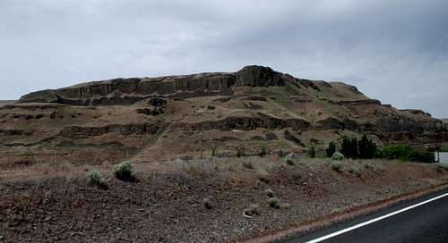 Lyons Head, "Clean" Greatest Prominence Point Of Walla Walla County
KNOWN WASHINGTON COUNTY PROMINENCE POINT COMPLETERS & NEAR-COMPLETERS
These are currently the only known completers and near-completers of the Washington CoGPPs:
COMPLETERS OF THE 39-PEAK ("CLEAN") LIST:
John Roper and Paul Klenke simultaneously completed the "clean" list together on October 26, 2008 at Weatherwax Ridge.
Edward Earl completed the "clean" list on June 30, 2009 at Round Mountain.
Bob Bolton completed the "clean" list on September 27, 2009 at Remmel Mountain.
Craig Willis completed the "clean" list on June 20, 2012 at Mount Baker.
Greg Schmidt completed the "clean" list on August 21, 2012 at Gold Mountain.
Paul Michelson completed the "clean" list on September 17, 2014 at Saddle Butte.
COMPLETERS OF THE COMPREHENSIVE ("DIRTY") LIST:
John Roper completed the list of known alternate possibilities on November 15, 2009 at Klicker Mountain.
Edward Earl completed the alternate list on December 25, 2009 at Klicker Mountain.
Paul Klenke completed the alternate list on September 27, 2010 at Table Rock.
Craig Willis completed the alternate list on June 20, 2012 at Mount Baker.
Greg Schmidt completed the alternate list on August 21, 2012 at Gold Mountain.
NEAR-COMPLETERS OF THE WASHINGTON CoGPPs ("Clean" or "Dirty"):
Paul Michelson requires just Klicker Mountain to complete the alternate ("dirty") list. He has already completed the official ("clean") list.
Bob Bolton requires just Altoona Hill and Klicker Mountain to complete the alternate ("dirty") list. He has already completed the official ("clean") list.
Ken Russell requires just Mount Rainier and Mount Baker to complete both lists.
RELATED FUN FACTS
Washington has a total of 39 counties, of which:
-> 32 of them have CoGPPs with over 1000' of prominence.
-> 24 of them have CoGPPs with over 2000' of prominence.
-> 15 of them have CoGPPs with over 3000' of prominence.
-> 11 of them have CoGPPs with over 4000' of prominence.
-> 7 of them have CoGPPs with over 5000' of prominence.
 Mount Saint Helens, Greatest Prominence Point Of Skamania County
SPECIAL THANKS
Special thanks should be given to peakbaggers Jeff Howbert and John Roper, both of whom worked together to create an initial CoGPP list for Washington in 2003. That initial list ultimately became the template that was fine-tuned to its present form by 2008.Thanks also to Andy Martin in 2006 and John Kirk in 2008, as well as Edward Earl, Paul Klenke, and Eric Noel, for their efforts to help make this Washington peakbagging category, and/or SummitPost page, more accurate and usable.
 Wahatis Peak, Greatest Prominence Point Of Grant County
EXTERNAL LINKS
John Roper has a section of his personal climbing website dedicated to Washington CoGPPs.Edward Earl has created a comprehensive list showing the first ascents for each of the Washington COGPPs.
PEAKBAGGER.COM contains a progress list of the website's members for Washington CoGPPs. However, this is not necessarily a complete progress list, as some potential seekers of Washington CoGPPs might not be Peakbagger.com members.
NOTE: The CoGPP list on Peakbagger.com only uses the "clean" list, with only a single possible CoGPP listed per county.
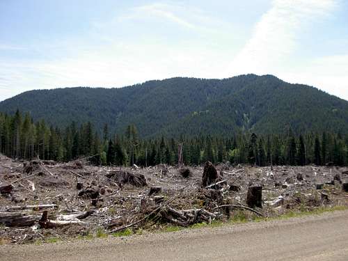
 Lakeview Peak, Greatest Prominence Point Of Cowlitz County