
-
 6887 Hits
-
 85.22% Score
-
 20 Votes
|
|
Mountain/Rock |
|---|---|
|
|
46.60220°N / 8.46080°E |
|
|
Trad Climbing, Sport Climbing |
|
|
Summer |
|
|
10085 ft / 3074 m |
|
|
Overview
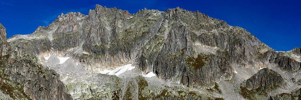
Lochberg 3074 m
The Urner Alps - or Uri Alps - are located in the Uri district, Central Switzerland. The massif is located amongst the three most popular passes in Switzerland: Sustenpass to the North, Furkapass to the South and Grimselpass to the West. This group is famous in reason of its compact and fine granite, that can stand comparison with the Mont Blanc one. Climbing Lochberg, a mighty castle-tower situated on the right-hand side of Winterstock Turm, from which this peak is separated by the saddle named Winterlucke mt. 2854, is only one amongst the numberless climbing possibilities in this magnificent area. In its Northern side Lochberg shows a small glacier in strong retreat; in the Southwestern side the peak offers a fine varied face, situated in front of the Albert Heim Hut, having some trad and sportive climbing routes.
Getting There
Road Access
The main resort in the Furka Pass Area is Andermatt, a little town lying at St. Gotthard Tunnel Northern exit. Andermatt can be suitably approached:
- From the Wallis via Sion, Brig, Gletsch and Furkapass
- From Luzern via Altdorf
- From Bern via Interlaken , Meiringen, Grimselpass, Gletsch and Furkapass
- From Milan (Italy) via Chiasso, Lugano, Bellinzona and the St. Gottard Tunnel
- From Chamonix (France) via Martigny, Brig and Furkapass

The starting point to climb Dammazwillinge is the Furkapass road, connecting Andermatt on the Eastern side of the pass and Gletsch, on the Western side. From Andermatt take the Furkapass road; before reaching the pass the road gets to the Tiefenbach Hotel m. 2110, situated along the road on the East side of Furkapass. It’s possible to park here or alternatively follow an unsurfaced military toll-road (7 CHF to be payed before taking the road), starting on the right a few hundred meters past the hotel. The road cuts the walking approach time of about 20 minutes and rises with some hairpins to the Tatsch parking m. 2270.
Red Tape

No particulary restriction in climbing and hiking. An entrance fee is due to get the Tatsch parking, where free camping is not allowed.
Via degli Amici report

***SW Wand
Difficulty: TD inf., F5c
Climbing length: 350 m
Equipment: trad (pegs) Climbing length:350 m
Exposure: SW
First ascent: F. Haider – S. Inwyler 1958
A classic trad route along steep and excellent granite.
***Via degli Amici + SW Wand exit combination
Difficulty: TD, F6a+ (F5c, 2 p.a.)
Equipment: bolts, pegs (SW EXIT)
Climbing length: 350 m
First ascent: Richi Arnold – Karl Stadler 1998
A varied climb over excellent rock equipped with bolts; SW WAND EXIT is not much equipped.

VIA DEGLI AMICI + SW WAND EXIT REPORT
One can access to the cliff directly from Tatsch parking m. 2270; otherwise it’s possible and very pleasant to spend the night at Albert Heim Hutte m. 2541 SAC (Swiss Alpin Club), open in summer.
Approach to Albert Heim Hutte – From Tatsch a good marked path leads to Albert Heim Hutte (1 hour and 15 minutes from the parking). It’s possible approach Lochberg reaching the hut and from here proceeding on a track towards East, but it’s quicker approaching Lochberg directly from Tatsch.
Lochberg direct approach - From Tatsch, instead of the Albert Heim path, head towards right (East) walking along a mainly level military road, leading to a small alpine hut, where the road ends. From here a track rises into a valley in the direction of Lochberg and Winterstock Turm. When you're getting to a characteristic marked fork, leave on your left-hand side the main path to Albert Heim Hut and Nepali Highway and head to right rising along steep stony ground. At a new fork before a snowfields head towards right, taking the trail in the direction of Lochbergluche, the saddle situated in right-hand side of Lochberg; rise a bit along this trail then leave it and go towards left. A last steep snowfield leads at the route’s starting point below a corner (1 hour and 45 minutes from Tatsch).
L1 – 5b, 50 mt. L2 – 5a, 35 mt. L3 – Now the climb becomes steeper 5b, 50 mt. L4 – 5b, 50 mt. L5 – 5b, 35 mt. L6 – 5c+ 2 p.a. (6a+), 35 mt. L7 – 5a, 40 mt.


From the seventh belay – route book – there are two options:
A- to end the climb without reaching the summit of Lochberg. In this case scramble a bit towards left – facing out – to reach the abseil line and gain the base of the face with seven abseils.
B- to reach the summit by climbing the upper section of SW Wand (longer, but very satisfactory). From the route-book climb a difficult chimney-crack, then climb up other three easier pitches along the summit ridge leading on the summit.
Descent: from the summit go down along a scree gully, then head to right – facing out – to reach the West ridge leading to the Winterlucke, the saddle between Lochberg and Winterstock Turm. A marked track goes down towards S (2 hours from the top to Albert Heim Hut).
Hut and other accomodation
Albert Heim Hut 2541 m
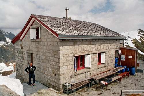
Owner: SAC (Swiss Alpine Club) Sektion UTO
Size: 80 places
Approach: in 2 hours from Tiefenbach or 1 hour from the Tatsch parking.
Albert Heim on Summitpost: Albert Heim Hut
Hotel Tiefenbach m. 2110
Other accomodation in Andermatt, where you can find some hotels and campgrounds.
When to climb
Best season goes from July to September
Meteo
Guidebooks and maps


- Guidebooks
"Schweiz Plaisir Ost" by Sandro von Känel - Edition Filidor 2015
"Schweiz Plaisir Ost" by Jurg von Kanel - Edition Filidor
“Arrampicare in Svizzera” Ed. Versante Sud
"SAC Guidebook - Urner Alpen" by T. Fullin - A. Bahnholzer
"Ascensioni scelte nella Svizzera Centrale" - Franco Malnati 1981
- Maps
Official Maps of Canton Uri: CNS - Urseren 1231 1:25.000 CNS - Sustenpass 255 1:50.000