Arizona in the spring is a welcome respite from home in Medford, Oregon. In April, 2008 I headed south from home, stopped in Death Valley for hikes on
Tin Mountain and
Last Chance Mountain before continuing on to Arizona and meeting up with my good friends
Dean and Rick. On the 14th we hiked
Browns Peak, then Rick had to head home to Prescott, while Dean and I continued on our way.
Our goal the next day was to hike
Mount Baldy, but it was not to be. The roads accessing the trailheads were under construction and closed. We will have to come back later for this one. Our next objective was
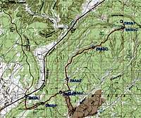
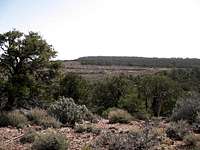
Black Mesa. Black Mesa is the highest point in Navajo County and is located on the Navajo Indian Reservation. I think the Hopi’s have a claim on the land also, but the Navajo’s administer access to Black Mesa.
We decided to play this one by the book because we didn’t want to offend any locals. We stopped in Cameron Arizona and bought a hiking and camping permit. We were charged $15 each for a day, a night, and a vehicle. Maybe it was 2 days since we spent the night and we obviously had to be there on 2 separate days in order to spend one night. I still have the permits and one charges $5 to camp for one night, and the other is the “backcountry use permit” that costs $10 for 2 days. The bottom line here is that they make up the fees and charge whatever they want. We paid the fees and headed to the Black Mesa trailhead.
![Black Mesa]()
The wind was blowing some in Cameron, but north of there on our way to Black Mesa, it started blowing harder. The weather forecast called for 50 mph winds and it was blowing that hard. Huge dust clouds were stirred up and obscuring visibility. We could only see a couple hundred yards ahead on the road and tumble weeds were blowing around. It was impossible to avoid them if they had you in their sights. We stopped in Tuba City for lunch at a local Subway. $5 for a foot long sandwich seemed like a good deal that would serve as both lunch and dinner. We pushed on up the road and located the turnoff near the big coal silo on Hwy 160.
Now the hard part began. I was leading because I had a few waypoints set in my GPS, but they were just a guess as to how they corresponded to the great directions provided by
surgent on the main Black Mesa page. As it turned out, the directions were right on the money and the GPS waypoints confirmed that we were heading in the right direction. The trailhead is a long way off the highway. We did have to stop and open a gate at a ranch about half way in to the top of the Mesa. No one challenged us, but it looked like people lived there. Dean noted that there was no sign saying Keep Out, or No Trespassing, so we opened the gate, drove through, and closed the gate again. I was happy that we had the backcountry hiking permit and the overnight camping permit.
![Black Mesa]()
![Black Mesa]()
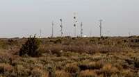
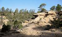
We continued on up to the top of the Mesa and found another locked gate off the side of the road where others have parked and hiked to the summit. There is a sturdy barb wire fence blocking vehicular traffic to the east where the highpoint of Black Mesa is located. It was still early in the afternoon, so we decided to explore a little more. We continued up the road and drove out to Lolamai Point. Lolamai Point has several communications towers and is on the edge of the cliff that overlooks the town of Kayenta. We looked at another locked gate near Lolamai Point and decided to spend the night along the road nearer Lolamai Point.
![Black Mesa]()
We found a flat spot just west of the road off in the brush. The brush isn’t bad. It is more like some well spaced short juniper and pine trees and a few desert bushes. We could basically drive wherever we wanted to, so we picked a nice spot to car camp for the night. The wind was still blowing hard, so we climbed into our respective vehicles for some respite, ate the second half of our Subway sandwiches, and let the wind rock us to sleep.
![Black Mesa]()
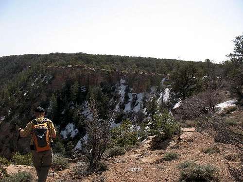
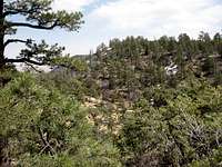
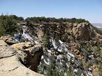
Sometime during the night (12:30 AM according to Dean) the wind stopped and we woke up to a clear calm morning. The air was still a little dust filled and the views that we could see were not crystal clear like you would expect in the desert. I know we couldn’t see Navajo Mountain to the north. We got an early start, climbed the barb wire fence, and headed cross country eastward towards the highpoint. We knew the highpoint was a long way across the Mesa (5.7 miles line of sight by GPS) and we had all day for the hike. We took our time and made our way out toward the edge of the Mesa. We picked up an old road bed paralleling the Mesa edge and followed it to the first obstacle. The first obstacle was a little canyon that we had to cross. There is a little route finding required to cross these canyons along the rim of the Mesa. There are sandstone ledges to navigate and you have to find a way down to the bottom of the canyons and then back up. I think the deepest of these canyons requires a drop of about 150 ft.
![Black Mesa]()
The directions we had were quite simple. Just follow the Mesa rim to the summit. After crossing the deepest canyon for Yellow Water Canyon we meandered around through the brush and trees and then found a nice road that crossed our path. I was convinced that going right on the road would lead us to the highpoint. Dean had some erroneous misgivings thinking it was off to the left. Our GPS’s pointed straight ahead. We went right on the road for a ways but the road seemed to be meandering off too far right, so we left the road and headed directly towards\the highpoint. In a few hundred yards we came to another canyon, only this one was not what I was expecting. We could see where the highpoint was and couldn’t get there by going further to the right. We turned left and followed the edge of this new canyon about a half mile all the way back up to near the edge of the Mesa and encountered the good road again. I did the only thing I could do under the circumstances and blamed our scenic detour on Dean for not insisting on going left when we first encountered the road. Be wary when hiking with Dean, he will let you walk off a cliff before he says “I told you so”.
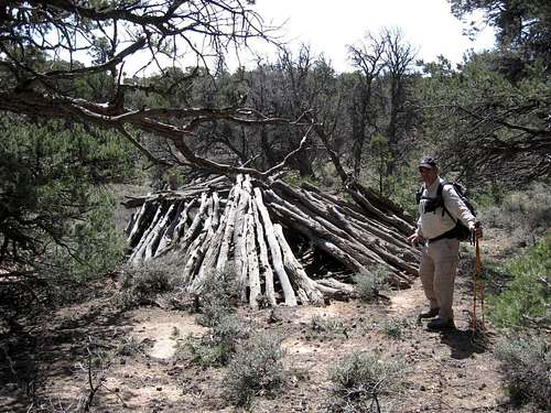
![An indian hogan?]()
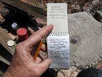
Once we were on the road again heading in the correct direction we made good time heading generally towards the highpoint. As the road rounded a point on the Mesa rim, we decided that we wanted to visit the Kayenta Benchmark. I had a waypoint set on my GPS for the benchmark and since I was paying much better attention to my GPS at this point, I led the way off the road directly towards the Kayenta BM. The terrain here is surprising wooded and you can’t see very far. It is easy hiking, but I had to keep an eye on the GPS and follow the red arrow towards my waypoint. We had to climb a little hill to get to the BM, but I redeemed myself and found the BM without another scenic detour. We signed the summit register, took a few pictures, looked at the map, and made sure our GPS units agreed on the direction to the highpoint of Black Mesa.
![Black Mesa]()
It was only a mile to the Black Mesa highpoint from the Kayenta BM, but there is no trail or road. There is a big open field area where there has been some commercial clearing of the small trees. We crossed the fields and made our way out close to the rim before following it to the highpoint. The summit cairn and register for the highpoint is the apparent highpoint that is sitting back from the rim at least a hundred yards. Dean likes the direct approach and walked directly to it, but I like to circle around some and eliminate all the lesser possibilities before approaching the high point. Soon we were together at the cairn and signed the register. There are no views from the highpoint because of all the trees, so we found a log to rest on and had lunch.
It was a nice hike with lots to look at all the way to the summit, but we were only half way done and had a long hike back to the truck. We picked up our packs and headed west. I let Dean lead because he needs the practice. We found an interesting place just southeast of Kayenta BM where there is what appears to be an old hogan. It was just the main and supporting log beams, but it was still interesting. Then Dean led us out to a cliff and we had to retrace our path a couple hundred yards to get back on track. I was glad Dean stopped before dropping off the cliff, because I would have followed him over the edge for sure.
![Black Mesa]()
We continued back and found the good road back to Yellow Water Canyon. On the west side of the canyon we picked up an old roadbed very close to the rim of the Mesa and followed this roadbed back all the way to Lolamai Canyon. The road went down through a couple minor canyons and over some extensive sandstone areas but we were able to stay close to it all the way. Another interesting find was what looked like a little grave. There was small circle of rocks with a larger flat rock in the center. A small wooden cross was in the dirt within the circle. It looked like a nice place to spend eternity, so we didn’t disturb it.
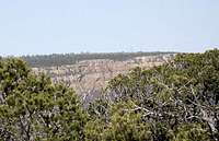
![Kayenta is down there]()
There is nothing technical about this entire climb, but there is a surprising amount of elevation gain to go from a trailhead at 7,960 ft and the summit of 8,168 ft. My GPS indicated by the end of the day I had climbed 2,106 ft. This was spread over almost 16 miles and 8 hours so it wasn’t any big deal. I actually enjoyed this hike more than I thought I would. It is scenic and easy hiking. I would recommend it to anyone, but make sure you pay attention to the route.
Comments
No comments posted yet.