Putting it Together
The idea began quite a while ago when I realized how close the Wind River Range actually was to where I live. The range has a reputation of being spectacular, but long approaches always kept me away. The short approaches and short drives to the Tetons and Lemhis kept me going to those ranges.
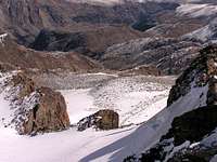
![Route Profile]() Route Profile
Route ProfileAfter seeing so many trip reports from the Winds this summer, one finally caught my eye, “
Gannett Peak, the Hard Way – In One Day”. Fremont Peak is less technical and ten miles shorter round-trip, so I ran the idea through my head.
I began to look for partners that I knew personally and most were not interested in a long trek. Others on the internet were too busy to be available for a break in the weather or they lived too far away. Finally, SPer gjagiels showed interest, experience, and a flexible enough schedule.
Since snow fell early this year, I wasn’t sure if we could ever get around to heading up. I was afraid that the summer season had already ended in the Wind Rivers for the year. After watching the forecast and the Pinedale webcam, hope returned. The entire week was going to be sunny, and the snow up high was melting fast. By the end of the week, the weather would still be great and hopefully the snow would not be an issue at all. Making a call to someone in Pinedale who could see the route the day before sealed the deal. They said they could see rocks sticking out through any light snow that was up on the peak.
Setting Out
I met Greg by the general store at the bottom of Fremont Lake Road at 1:00 am that morning. I had slept in the parking lot on an air mattress in the back of my car for a couple short hours, and Greg came right up from Salt Lake. After doing some last minute sorting in the cold night, we headed up to the Elkhart Park trailhead.
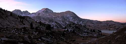
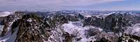
![Predawn Silence]()
Headlamps on, we started up the trail at about 2:00. Surprisingly, it was not as cold as we had anticipated. It was comfortable enough to keep cool while walking at a good pace and not freeze. Along the lower portions of the trail, we ran into a bit of ice and snow among the trees, and hoped that snow would not be a major obstacle further along the trail in the alpine basins. At this point, we really didn’t know what we were heading into. We just kept going. I predicted a conservative pace of two miles per hour along the approach. We kept a good pace and reached Photographers Point in an hour and a half. Ahead of schedule, the success of this crazy day hike seemed more assure, even at this early hour. But there were many miles left to go.
The Mountains Reveal Themselves
After miles of headlamp use and tunnel vision on the trail, the sky began to give a soft glow to the area around us. We were on the trail along Seneca Lake, and across the lake the mountains were lighting up as well. At this point the light was still too soft to tell if the slopes were covered in snow or granite. We hadn’t run into snow since way down near the trailhead, however, so we really didn’t have any concerns about making it to the Southwest Buttress.
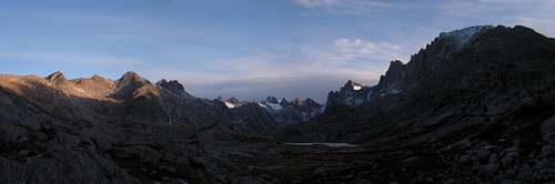
Light slowly began to fill the sky, and the mountain skyline emerged. At this point we were excited to be where we were. These were real mountains. Glaciers glowing white before dawn, still miles to go before we would be on the taller mountains themselves. The landscape around us was glacially scoured and rugged in all directions. Right on track, we kept walking. Climbing out of Island Lake, the sun finally rose. We were already twelve miles into the trip.
Approaching Fremont
Turning the corner into Titcomb Basin, we realized we were off track and had passed the trail into Indian Basin. Greg whipped out the GPS and led toward the route he had marked. The ascent into Indian Basin would be up to that point the longest uphill section before the summit push. We still hadn’t seen the sun yet, and when we entered Indian Basin, we were glad to see the sun hitting the rocks a few hundred yards away. We took out first substantial break once we made it to the sun. I shed a layer of clothing and had a little to eat.
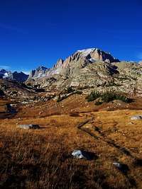
![Indian Basin]()
Greg didn’t want to waste much time and was ready to get up to the base of the buttress. Rock hopping along the edge of the lakes in the basin, the mountain gave a subtle reminder of who was in charge… Clack, Click, Clack, Clack!... the sound that makes a climber’s hair stand on end. Rockfall. From Fremont’s south face, refrigerator sized boulders tumbled down, bringing lots of other boulders along with them. We were out of range and at a safe distance, but it was still an event to get the adrenaline pumping. I didn’t see many rocks myself, but the sound enough got the point across.
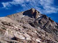
Climbing safely out of range of any more rockfall, we arrived at the col before the Southwest Buttress. Slightly breezy, we gazed up at the final scramble as the peak towered above.
Summit Push
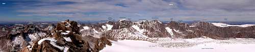
The scramble on Fremont Peak is one of the most pleasant scrambles I’ve done. Solid rock and many route options, the route became easier when we ran across steps already kicked into the snow higher up. The snow was not an issue, and even made the route to the top easier. From this point to the summit, it was one foot in front of the other. Getting above 13,500 the altitude took its toll, and we slowly made our way up the last 200 feet until the summit suddenly appeared and hundreds of feet below the Upper Fremont Glacier filled your view.
The rest of the high peaks of the Wind River Range come into view. The vastness of the range presents itself in full fashion from the summit of Fremont Peak. Huge glaciers, deep canyons, and an endless horizon of glacially carved granite spread out in all directions. The Wind River Range may be the prime range of the American Rockies. And here we were, in the middle of it all.
Breezy and cold, we decided that after all that effort to get here, it was time to head back.
Descent
The descent on the Southwest Buttress was uneventful. The steps that we had taken up were beginning to soften in the sun. It didn’t take nearly as long to descend to the col as it did to go up. Reaching the base of the Buttress, the way back from here was going to be easy. We had successfully ascended and descended the most difficult part of our day, and it would be straightforward from here.
Greg suggested that we descend into Titcomb Basin. The way down didn’t look any more challenging than what we had already done, and there was a climbers trail leading down. I was all for shaving a bit of time on the way out.
Things began to look a little more difficult the further down. Between slick grassy ledges and smooth granite, our little shortcut became more complicated. Greg navigated down to Mistake Lake pretty well. Somewhere between the summit and here, however, I began to experience pain in my right ankle. Any dorsiflexion, bending my foot back to take a step, would hurt. Favoring my ankle, halfway down to the basin my calf began to cramp up. I slowly made my way down the slopes while Greg patiently waited.
I was pretty upset. I knew I had a lot of traveling left to do today, and we were now a few hours behind schedule by the time I finally made it to the lakes below. I took a quick break, changing socks and reenergizing, figuring I would be back up to speed and ready to book it out to the trailhead. The air was warm, surprisingly like summer weather, and the afternoon sun made the range look as great as ever.
Long March Out
The rest of the day would be the same pattern as earlier, unfortunately. I would go along at a pace that wouldn’t put too much stress on my ankle, and Greg would go at a healthy pace, then wait for me to catch up. Expecting the trail out to be more friendly with my condition than the scramble above, I was disappointed to see that navigating the rocks and roots in the trail would be difficult as I still had to conform my foot to the rough terrain.
The sun was going down. By the time the sun fully set, we still had at least nine miles to go. I had planned to be back to within an hour of the trailhead by this time. At the pace I was going, it would take me another four hours to get there.
The way out was endless. If felt as if Mother Nature had shut down for the night. Ice crystals began to form on branches again. I could see my breath once again. Granite and snow began to glow softly in the low light, just as it had many hours ago on the approach. Headlamps came back out and the tunnel vision of endless trail began once again. Every step would send a little pain through my ankle. I had no choice but to go on.
Every lake on the route would discourage me. I expected every lake to be the last before Photographers Point, but another one would show up along the trail. Soon we reached Photographers Point and the home stretch. Still four miles and at my pace who knew how long before the day would end. “Go, go, go,” I would tell myself, every step with my right ankle throbbing. At this point the route entered the snowy and icy portions of the trail. I knew I was getting close, but when? The trail would not end and my foot did not feel any better.
Finally, after a tunnel of forest for what seemed like hours (and it was), I could see the orange parking lights and hear the idling engine of Greg’s car. It was over. We drove down to Pinedale. I crashed on the air mattress in the back of my car, and Greg continued on to Salt Lake.
After generous portions of ibuprofen and a few days of rest, my ankle stopped aching. After all is said and done, one question remains… Anyone want to climb some more mountains?


Comments
Post a Comment