
-
 7235 Hits
-
 83.69% Score
-
 17 Votes
|
|
Mountain/Rock |
|---|---|
|
|
36.87257°N / 3.76436°W |
|
|
Hiking, Canyoneering |
|
|
4879 ft / 1487 m |
|
|
Overview
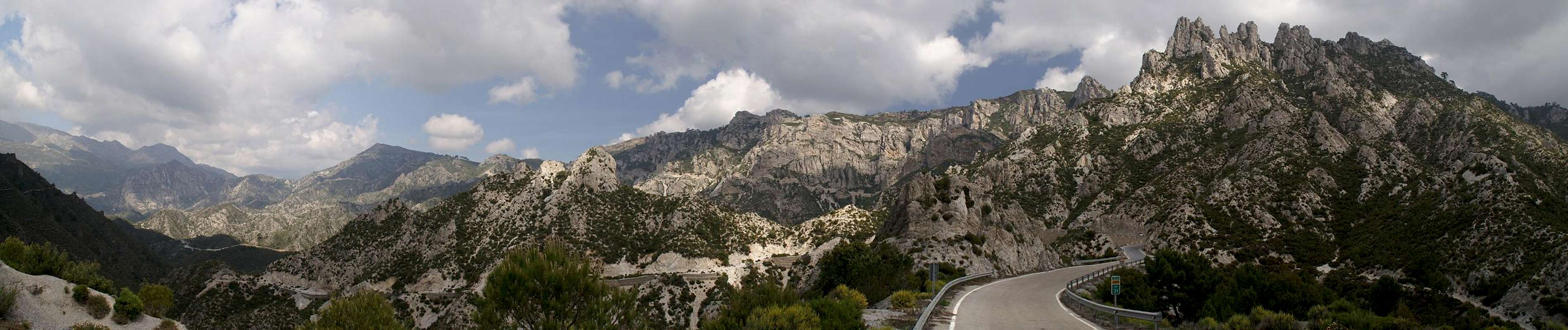
 Navachica (1832m) and Lopera (1487m) Navachica (1832m) and Lopera (1487m) |
Lopera is the easternmost summit of Sierra de Almijara in southern Andalucia. It is an easy summit, located only an hour from the nearest trailhead on A7106, the highway which connects Almuñecar on the coast with the town of Padul on the high plain near Granada. From its eastern side you can stroll up to the mountain's top - in fact a stroll which is far from beautiful as the area around the mountain is cut through by fire aisles. On the top you find a container-like construction, a weather station to measure the monthly deposits of rain.
 |  |  |
On its western and southern sides, however, Lopera has steep faces which drop off into the labyrinthine mazes of the canyons which make up the drainage of Rio Verde 800m underneath. In fact, Lopera is the only place to overlook the canyons and it is a good idea to visit its top before venturing into the maze. Rio Verde, which runs to the sea at Almuñecar, draws its waters from the barrancos in the eastern Sierra de Almijara. Since the underlying rock of the Sierra is brittle limestone the creeks of the area have cut deep into the rock forming narrow and winding canyons. The abundance of water and the multitude of creeks formed this labyrinth of rocks which nowadays is a popular canyoneering destination.
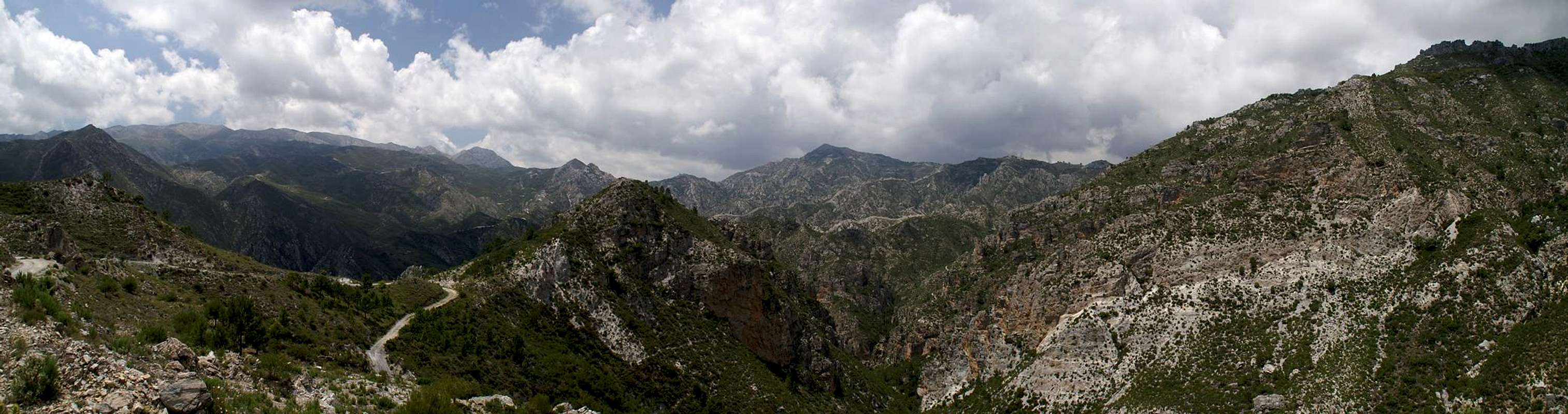
Usually climbers head down into the canyons from two trailheads on A7106. Dirt roads lead directly to the entrance points of the barrancos and it takes a lot of bushwhacking to gget across the first stages and to enter the barranco ground. In general the canyons are level with big steps occurring wherever two barrancos meet. Here usually big waterfalls bar the way and it requires good rapelling technique to get to the next level. The narrowest part of the canyons is located south of Lopera's summit, where quite a number of creeks join forces at a small distance and the most difficult part is where Rio Verde heads out of the mmountains to the west of the small town Otivar. From the barranco ground Lopera appears as a massive triangular mountain, which towers right above the upper part of the canyon.
 |  |  |  |  |
The canyons of Rio Verde are famous for their many waterfalls. The best known of them is Cascada de los Árboles Petrificados where logs which have come down the cascade over the years have attained a thick layer of calcite, making "petrified logs" out of them.
Getting There
  |
Both the trailheads to Lopera and to the Rio Verde Canyons are located on a narrow mountain road, A 7106, which winds from Allmunecar to Padul through the border region between Sierra de Almijara and Sierra del Chaparral. You can reach them easily from the airports of Granada and Malaga as follows:
- From Granada
- Take motorway A329 in direction Granada.
- At the intersection to A44 switch to the latter in direction Motril (south)
- Leave the motorway at the exit Padul and follow the country highway A7106 in direction Almuñecar.
- Both trailheads have maps to indicate the hiking trails. You'll find them at km 32 (Lopera) and 28 (Rio Verde).
- Take motorway A329 in direction Granada.
- From Malaga
- Take motorway A7 through the city in direction of Motril
- The motorway ends at Nerja. Switch to N340
- In Almuñecar switch to A7106, direction Otivar
- The trailheads are at km 28 (Rio Verde) and 32 (Lopera) respectively.
- Take motorway A7 through the city in direction of Motril
Red Tape
 Dynamic Lizard
Lopera and the Rio Verde Canyons belong to the Parque Natural de las Sierras de Tejeda, Alhama y Almijara. The usual restrictions apply. The ranges are used for farming and mining so you are free to use the web of dirt roads which covers them. Aside the roads you are requested to stay on the trails, which generally are well maintained. Staying overnight is not allowed in the natural park.
In Rio Verde canyoneering is allowed if you follow the dirt road to the upper part of the canyon.
Accommodation
 |
The Costa de la Sol is one of Europe's major vacation getaways and there are all types of accommodation to be found. Hotels, apartments, fincas can be booked from any tourist office all over Europe and there are many sites on the net which deal with the area.
The closest town is Almuñecar, 28km to the south of the trailheads. You can find all types of accommodation there. The closest campground is in Almuñecar itself.
Weather Conditions

Maps & Books
There is a good map of Sierra de Almijara, which, however, is hard to come by. It even shows Almendrón on its cover.- Sierra de Almijara Mapa Topographico
Editor: Miguel Angel Torres Delgado
1:25000
ISBN: 978-6-99-000430-3
As guidebook I can recommend the following one which is available in German and English
- Andalucia South / Andalusien Süd
Costa del Sol – Costa de la Luz – Sierra Nevada
Bernhard Plikat (translation: Gill Round)
Rother Verlag
ISBN 978-3-7633-4824-4 (English)
ISBN 978-3-7633-4147-4 (German)