


Comments
No comments posted yet.
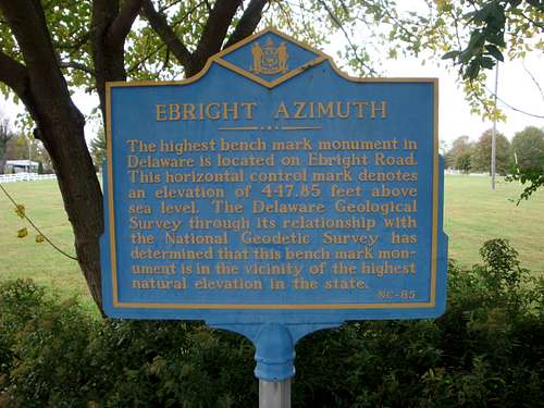
A block from the Pennsylvania/Delaware border in Wilmington, Delaware, and about 30 miles from Philadelphia, Pennsylvania, is a spot known as Ebright Azimuth. This spot, accepted as the highpoint of The First State, is denoted by a sign located along the busy residential Ebright Road. The approximately three foot wide by two and a half feet tall blue sign is mounted on a three-foot pole.
The inscription on the sign states, “The highest bench mark monument in Delaware is located on Ebright Road. This horizontal control mark denotes an elevation of 447.85 feet above sea level. The Delaware Geological Survey through its relationship with the National Geodetic Survey has determined that this bench mark monument is in the vicinity of the highest natural elevation in the state.”
~~~
Of all the 50 state highpoints, Delaware has the second to the lowest one, yet it can claim a first with its highpoint having the most unusual name - Ebright Azimuth. The first half of the name seems obvious as in 1933 when the land was initially surveyed it belonged to Grant and James Ebright. But why does the mystical sounding “azimuth” follow instead of something like hill, point, or mound? As I have investigated this, I have found no documented reason for the name. However, I have arrived at a very plausible explanation about how the name came to be.
Studying the word azimuth first led me to its association with a compass. Each of the degrees between 0 and 360 marked on a compass face represent a direction. For example, 270 degrees represents west. Technically, such direction numbers are called azimuths.
Finding no correlation between a compass and a land highpoint, I continued my investigation. Coming across the survey term “azimuth mark,” I soon determined it to be the key to understanding the Delaware highpoint name. To understand this, a brief explanation of survey marks follows.
A survey mark is a point on the earth for which an accurately measured location, either horizontally or vertically has been determined. Typically, a metal disk about three and a half inches in diameter is affixed to identify the location. These metal disks are often encountered on mountain tops firmly cemented into solid rock.
Survey marks are known by various names, such as monuments, points, bench marks, and stations. These names might also be preceded with terms such as primary, reference, traverse, topographic, horizontal, vertical, control, and triangulation. There are technical reasons for these names, but in common, everyday usage, the terms end up being used interchangeably. For example, a bench mark (a type of vertical control) is a point of precisely measured elevation. However, some might call a monument concerned only with horizontal positioning (aka latitude and longitude) a bench mark.
Usually, a primary horizontal survey mark will be accompanied by one or more reference marks. Primary marks and reference marks both use the same sized disks typically made of either bronze or aluminum. Reference marks are stamped in the center with a crossed arrow symbol and are meant to be set with their arrow symbol accurately pointing toward the corresponding primary mark.
Bench marks are often factory stamped with “B.M.” or with “BENCH MARK” as well as with the standard crossed slash symbol in the center used to identify a vertical control. Sometimes, however their center symbol varies from the standard one. Horizontal control marks are stamped with an equilateral triangle symbol at their center. Contrary to popular belief, survey monuments are not necessarily placed on a highpoint - rather their locations are chosen with visibility in mind.
There is a special type of reference mark which is a long-range one. Unlike a normal reference mark which is typically located within 30 meters of the primary mark, a long-range one is usually set between a quarter of a mile and two miles from the primary mark, give or take. Long-range reference marks are known as azimuth marks.
Reference marks, including azimuth marks, serve two purposes. First, they provide a point from which a surveyor can locate a primary mark. Secondly when both a reference mark and a primary mark are located, the reference mark allows the surveyor to know the exact direction, aka azimuth, in which he is looking. As such, accurate measurements can then be taken.
As a result of my investigation, I have concluded the name “Ebright Azimuth” is an outcome of the stampings found on a reference disk located along Ebright Road. Because the disk is stamped with both the survey name “Ebright” and the type of reference mark “Azimuth,” people read those together concluding “Ebright Azimuth” to be the name of the highpoint.
~~~
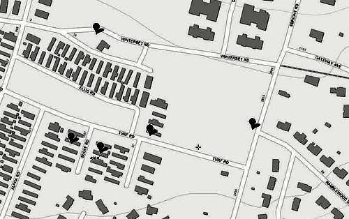
Travelling from the Pennsylvania highpoint, 230 miles distant, I arrived at Ebright Azimuth the afternoon of October 19. As I approached from the north, I did not detect any increase in altitude as it was a rather flat drive through a suburban neighborhood. I do not recall seeing a sign announcing Delaware. I simply knew that from the point I left PA-491, getting on Ebright Road heading south, my destination would be reached in six tenths of a mile.
At the Ebright Road and Ramblewood Drive T-intersection I encountered a three-way stop, with the blue “Ebright Azimuth” sign to my right, and Ramblewood Drive a left turn. I made the left, and parked in front of the second house on the north side of the street, the local time was 2:30 p.m.
I wandered over to the blue sign on the west side of Ebright Road taking a photograph of it. After reading its inscription I thought, “what a confusing jumble of words that is!” One has to wonder what bench mark, monument, horizontal control, or mark the sign refers to. Could it mean the blue sign itself is some type of horizontal bench mark control monument - if there is even such a thing? “In the vicinity of the highest natural elevation in the state” the blue sign states. Even though my prior research had tipped me off to the “vicinity” puzzle, I still mumbled, “I came here for the highest point, not the vicinity of the highest point.” One has to ask, “What in the world is going on? Where is the highpoint of Delaware if it is not at the blue sign?”
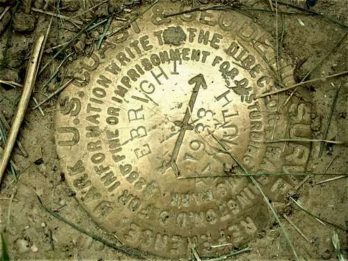
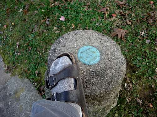
As I was prepared for the confusion the blue sign causes, I did not dwell on it. Instead, I strolled down Ebright Road a dozen steps to the south, and located a long-range reference survey monument situated in a cutout along the sidewalk. First thing to note about the disk is that it is factory stamped in capital letters with the words “REFERENCE MARK.” This begs the question, “is it correct to call a reference mark a horizontal control, as the blue sign seems to claim?” Since it is a reference mark, that means it was placed to point to a primary station. Second, field stamped on the disk are “EBRIGHT,” “AZIMUTH,” and “1933.” “EBRIGHT” and “AZIMUTH” are separated by the factory stamped arrow and the field stamped year “1933.” Third thing to note is the disk is lower than the sidewalk demonstrating this area is no longer natural - survey disks are set in visible locations, so obviously the ground around it has been built up over time.
In 1933, factory stamped azimuth mark disks had not yet been introduced. As such, being methodical, the surveyor included the word AZIMUTH making it clear the Ebright reference mark is a long-range one.
~~~
Why does the blue sign claim a horizontal control resides on Ebright Road? Could there be another disk on Ebright Road that is actually a primary horizontal control mark at an elevation of 447.85 feet? If that were true, the arrow on the azimuth mark would need to point parallel to the road which it does not.
Perhaps the blue sign should state, “[The] horizontal control mark” instead of “This horizontal control mark” - as in the horizontal control mark pointed to by the azimuth mark - “denotes an elevation of 447.85 feet above sea level?” Nevertheless, since there seems to be only one survey monument located on Ebright Road, it seems likely the blue sign is using survey terms colloquially by calling the azimuth reference mark a horizontal control. As such, perhaps the azimuth reference mark has been officially determined to be at an elevation of 447.85 feet above sea level and may well in fact be “the highest bench mark monument in Delaware.” On the other hand, being part of the network that points to a primary horizontal control, perhaps it is acceptable to call a reference mark a horizontal control. After all, being more allusive than “reference mark,” “horizontal control” is less likely to cause highpointers to search the residential neighborhood for an exact highpoint.
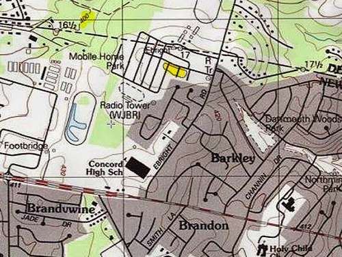
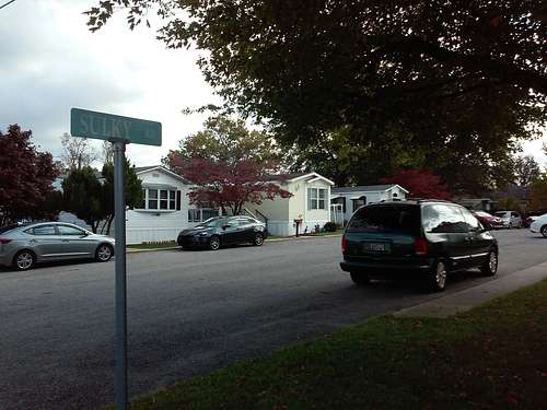
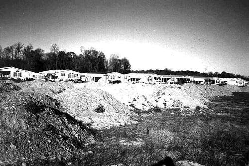
Located 400 feet west of the Ebright Road azimuth disk is a mobile home park in which the World Topographical map shows a spot with an elevation of 450 feet. Likewise, the U.S. Topographical map contains a contour line of 450 feet extending across both Sulky and Alpha roads in the mobile home park. According to the World Topographical map the 450-foot elevation spot is located on the south side of the second trailer on the east side of Sulky Road.
~~~
Having taken photographs of the blue sign, and having located the azimuth mark, next, out of curiosity, I wandered down Turf Road into the trailer park. Inside the trailer park, I turned down Sulky Road. From a distance I took a photograph of the second trailer - wondering if a bench mark is located under it as urban legend claims. For good measure I next made my way to the end of Alpha Road, figuring in the process I crossed the 450-foot contour as shown on U.S. Topographical maps. With that out of the way, my next objective was to locate a person by the name of Doreen Kupchick.
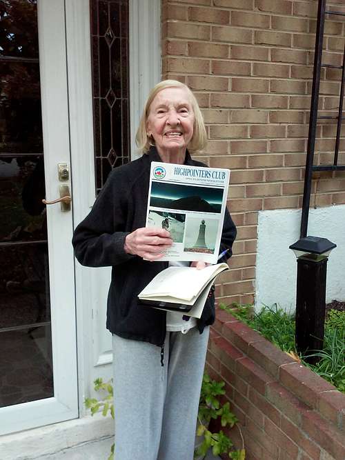
Ebright Azimuth and Doreen go hand in hand. Doreen was instrumental in reinstating the azimuth disk on Ebright Road when it was cemented over, plus she keeps a highpoint logbook at her home east of Ebright Road. Returning to the vicinity of my rental car I knocked on the door of the home I guessed belonged to Doreen. Fortune was with me, as not only did I get the right door, but Doreen answered it. Through my COVID-19 mask I explained what I was doing, and I asked to sign her highpoint logbook. Retirement-age Doreen did not seem worried by a masked stranger being at her door. She asked if I had visited the blue “Ebright Azimuth” sign and survey monument on Ebright Road. When I said I had she said she would get the book ready but suggested that in the meantime I head over to a second survey disk on Winterset Road.
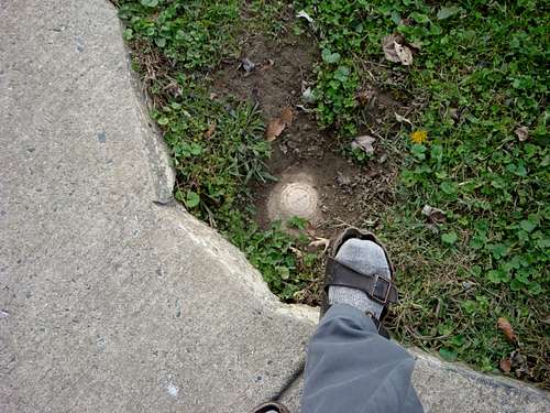
I had planned to locate the Winterset disk after signing the logbook but doing so before worked equally as well. The Winterset disk was easily found as it is mounted on a concrete base sticking approximately a foot and a half above the ground. Its location is at the curb in front of the old Winterset farmhouse and across the street from the old Winterset icehouse. Like its partner on Ebright Road it too is factory stamped with an arrow distinguishing it as a reference mark.
Winterset Road seems to be the Pennsylvania/Delaware border, and Doreen made a point of telling me I should get a photograph while in both states. Following the jaunt to the Pennsylvania/Delaware border, I returned to Doreen’s home and signed the highpoint log.
~~~
In the wake of this highpointing trip, I consulted the National Geodetic Survey (NGS) website and found an official datasheet for “Ebright.” The datasheet gives the official latitude/longitude of the primary control station, which both the Ebright Azimuth reference mark and the Winterset Road reference mark point to, as 39.837183 N/ 75.522097 W.
The datasheet clearly states the designation, aka name, is “Ebright” and not “Ebright Azimuth.” Under its 2015 section the official datasheet states, “Measurements for the station mark fell under the pavement of a paved parking area. Reference marks 1 and 3 and the Azimuth Mark were recovered in good condition. Reference Mark 1 is set in the top of a concrete post which projects about 20 inches (51 cm) above the surface of the ground.” The previous quote confirms the two survey disks I found are the azimuth mark on Ebright Road, and reference mark 1 on Winterset Road. Interestingly, the primary control is roughly 35 meters, at about 260 degrees, from the Winterset Road reference mark 1.
Along the 300-degree azimuth line, which is about 0.2 miles long from the Ebright Road disk to the primary horizontal control, are ten or more mobile homes. The datasheet states under a 1979 entry, “The Azimuth Mark is no longer visible from the ground, there are several mobile homes on the line.”
Further confirming the primary station’s location are directions to it under the datasheets 1960 header, given as “go east on Naamans road for 1.0 mile to Ebright Road left. Turn left on Ebright Road and go 0.6 mile to side road left leading to trailer court and AZIMUTH MARK on the left. Continue 0.05 mile to private driveway left leading to Mr. Merchants home. Turn left and go 0.1 mile to the south side of Mr. Merchants home and station.”
Unfortunately, but understandably, being a horizontal control the NGS datasheet does not list the elevation above sea level for “Ebright.” Nevertheless the 1970 guidebook titled “Highpoints of the States” by Frank Ashley seems to clear that up offering 442 feet as its elevation. Because the book mentions the Delaware highpoint is under pavement, I believe it is referring to the NGS datasheet “Ebright” primary control. Likely, Mr. Ashley assumed this horizontal control marked the highpoint.
~~~
Ebright Azimuth is in an urban area that has been excavated, landscaped, and paved. Photographs show that in the process of developing the land, backfill has been added changing and disturbing the natural elevation.
All things considered, we are left hanging, wondering what might have been the exact highest natural point and elevation of Delaware, which seems now to be lost forever. Understandably, the blue sign on Ebright Road is recognized as the highpoint of Delaware since there does not seem to be any other point more credible. As the blue sign states, “in the vicinity of the highest natural elevation” is about as good as can be expected for a residential neighborhood that has been disturbed from its native condition.
Looking back into history, it seems the Delaware highpoint has always been surrounded by uncertainty. A 1909 National Geographic article titled "The Highest Point in Each State” declares, “The highest points in Delaware are two rounded summits, one a mile east of Brandywine, and another just south of Centerville, both of which are slightly over 440 feet.” For the Delaware highpoint, in 1936 Arthur Harmon Marshall visited “Centerville, Del. (town)” the month before he became the first to complete highpointing every U.S. state. Frank Ashley’s book from the 1970s calls the Delaware highpoint “unnamed.”
Having reached the recognized highpoint of the blue sign on Ebright Road, as well as finding two visible survey monuments, and having walked on the 450-foot contour found on topographical maps, I feel I wore both my belt and my suspenders in Delaware.
I left the area around 3:30 p.m. and headed south on Ebright Road to Naamans Road noticing a slight drop in elevation on that side of the highpoint. After a short break at a local shopping center, I decided to head toward High Point State Park, New Jersey with the hope of finding camping along the way.
The author’s highpointing calling reaches back to May 2001 when he and two friends, having never heard of highpointing, drove to the top North Carolina’s Mount Mitchell. By the fall of that same year he tagged a second highpoint without yet having a goal to reach all fifty. Over the next eight years he completed another six, followed by another seven between 2010 and his 2014 climb of Denali. Following Denali he tagged another four, and then went into highpointing hibernation for over four years. August 2019 his highpointing desire returned and over the next couple of months he increased his highpoint count to twenty-nine.
Recognizing his remaining twenty-one highpoints seem less physically severe, the author began to wonder what percent of the total physical effort he had remaining. As such he developed the Effort Scale. Although his remaining highpoints account for less than 4.0% of the overall physical effort he knows they will not come without other types of struggles. He is not holding himself to it, but he hopes to complete all fifty within a twenty-year timeframe before June 2021.
As of October 21, 2020 the author completed Alaska and the lower 48 states, leaving only Hawaii to go.
Due to the world-wide COVID-19 pandemic travel to Hawaii proved to be excessively problematic prior to July 2021. Once Hawaii opened to fully USA vaccinated travelers the author straight away visited the Big Island. By summiting Mauna Kea July 22, 2021, he concluded the amazing pursuit of standing on the highest point of each of the 50 US states. This huge, worthwhile, goal spanned 20 years and 2 months! Read my Summitpost article about my U.S. state highpointing journey.
Want more details? I have published a book about my journey to the highest point of every U.S. state. The book, All Fifty: My Journey to the Highest Point of Every U.S. State, is available on Amazon.com.