
-
 10826 Hits
-
 79.78% Score
-
 11 Votes
|
|
Route |
|---|---|
|
|
38.44076°N / 111.20424°W |
|
|
Hiking, Scrambling |
|
|
Spring, Summer, Fall, Winter |
|
|
Less than two hours |
|
|
Potential for some easy scrambling |
|
|
 The Route


Overview
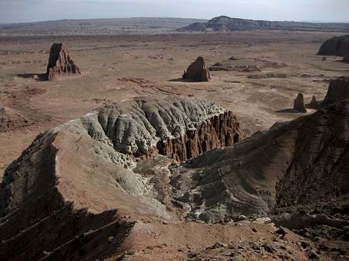
Almost every visitor to amazing Cathedral Valley, and there are not many, sees and admires the Temple of the Sun and the Temple of the Moon by driving onto the signed spur road from the dirt road connecting Caineville and Cathedral Valley Junction. There is nothing wrong with that. Hell, of the four times I've been there myself so far to see those incredible formations, three of them were purely car tours.
But there is another way to see this dramatic landscape, all part of Lower Cathedral Valley, and it is from a vantage that only a small handful of the already-small handful (relatively speaking) of visitors to Cathedral Valley ever see or even know about. Instead of gawking up at the formations, you gawk down upon them. It is a short, moderate hike with the added possibility of some easy scrambling detours that pay big dividends.
Ridge traverse + solitude + great views = satisfaction.
Getting There
2.7 miles east of the boundary of Capitol Reef National Park, look for a signed dirt road leaving Utah 24 and heading to the Fremont River. In short order, you come to the crux of the drive, if you will: River Ford. This crossing is for high-clearance vehicles only, and it is a good idea to have four-wheel drive as well. Make sure you check the water depth first; sometimes the water is little more than ankle-deep, but I have found it knee-deep on occasion, and I have no doubt it gets even deeper after storms and during spring runoff.
After crossing the river, drive about 17.3 miles to a small parking area and trailhead (this point is 17.6 miles from UT 24 and 3.5 miles past the turnoff for Lower South Desert Overlook), passing through spectacular bentonite hills along much of the way. This page features a picture of the trailhead sign.
Beyond the river crossing, the road is an easy drive, but the road is dirt, sand, and clay and should be avoided in wet conditions or when rain is likely.
Should conditions at River Ford not be suitable for crossing, you can drive east another 7.8 miles to Caineville Road (9.5 miles from the Capitol Reef boundary). However, it will be a very long approach to this route that way; the one-way distance will be nearly 41.5 miles.
You can also approach this route from I-70 at Exit 91. Follow the main trunk road almost 27 miles, first east a few miles and then mostly due south, to Cathedral Valley Junction and then head right to climb from Upper Cathedral Valley to the plateau above, where the road leads to River Ford. The total approach for the route this way is about 42.5 miles.
All these other roads are dirt, sand, and clay as well and should also be avoided in wet or potentially wet conditions. The climb from Upper Cathedral Valley to the plateau is rough and steep in places but not difficult.
Route Information
From the trailhead, two saddles are visible. The sign indicates that each saddle is a one-mile hike away; they feel a little closer than that, but each is still at least three-fourths of a mile away. Total elevation gain is only up to 500' and that is only if you follow Option 3. Using Option 3 makes the round-trip distance around 2.5 miles.
This route can be just a hike, or it can be an easy scramble. I strongly recommend Option 3 for the best mix of route variety and scenery.
Option 1
Hike to either saddle and then hike back. This seems to be what most people do. There is a cairned route to the western saddle, and that route helps you avoid the biological crust out here; it is alive and is critical to the desert ecology, and it is fragile. If the soil looks lumpy, dark, or crusty, avoid it. Better yet, try to stay on exposed rock and in sandy washes as much as you can.
I did not find a cairned route from the eastern saddle back to the trailhead. Instead, I followed washes most of the way. When the washes started heading away from the course to the parking area, I stayed on rocks as much as possible in between washes in order to avoid damaging the crust.
Option 2
Hike to one saddle and then traverse the ridge to the other. Almost every step of this is Class 2, but there is some easy scrambling on the "summit" above the eastern saddle. You get a better range of views this way and don't have to go back the way you came.
Option 3
From the western saddle, hike up the ridge to the closest outcrop and then scramble down to the obvious ridge leading out to Lower Cathedral Valley. In places, the going is very steep and loose and the ridge is narrow, but it is going to be a mere hike for most climbers and scramblers. The ridge ends at a vantage point that is simply spectacular; the eroded spires of Lower Cathedral Valley are right below you, and colorful cliffs are all around.
Essential Gear
Nothing special, but carry plenty of water, especially late spring through early fall.
You are in a remote area. Help is far away, and wet weather can turn the roads to gumbo and strand you. I recommend having enough food and water to spend two extra nights out.
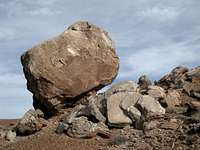
 This is the reason why...
 Click for key to the numbers.