Trip Report
We hiked Lundin Peak for our first BOEALPS BCC Experience Outing. We chose to roughly follow Fred Becky's winter route suggestion.
At 6:30am, we met in the Snoqualmie Summit West parking lot. We left our cars at about 7am. We walked a few hundred feed down the road, then left the road and began following an obvious winter trail which was heading roughly North in what we (correctly) predicted would eventually intersect with Commonwealth Creek. When the nicely packed trail ended, we began kicking our own steps. We used Commonwealth Creek as a handrail to our left as we progressed north up the Commonwealth Basin.
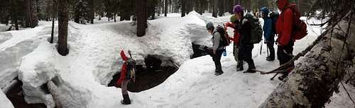
At 8am and 3600', we crossed to the west side of Commonwealth Creek on a snow bridge, then continued using the creek as a handrail as we progressed north up the basin. We continued following the creek as it branched to the west of Red Mountain.
![lundin_snowbridge]() Crossing a snow bridge
Crossing a snow bridge
At 10am, we reached 4600' and began hiking up a steep avalanche gully, hugging the rock cliffs on the east side of the gully.
At 11am, we topped out on the ridge at about 5900', just east of the true summit at 6050'. The eastern approach to the summit block is a very exposed class 4 scramble followed by a short exposed traverse. Given the very icy conditions, we chose to set up fixed lines and a rappel. We spent nearly 6 hours huddled in a snow trench just below the ridge as we took turns making the final summit.
At 5pm we began our descent, glissading down the steep gully and following our route back to the cars. We reached the cars at 7:30pm.
Comments
No comments posted yet.