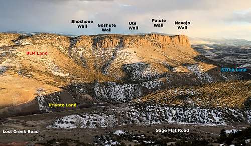
A relatively unknown granite/quartzite/basalt rock crag perched 700 feet up Black Mountain near Lost Creek just south of Salina, Utah. Formerly named Squaw Ledge, which is offensive in many Native circles, the name was changed to Nuwuvi, which means Southern Paiute in their language. The rock is relatively low-quality with lots of choss and moss so likely uninviting to many would-be climbers. The area is divided into 5 walls named after the Native American tribes of Utah. From North to South, they are Shoshone Wall, Goshute Wall, Ute Wall, Paiute Wall, and Navajo Wall.
Mogone Ledge Overview
Getting There
Take Utah State Route 24 from Salina and take a left onto Sage Flat Road after 1.4 miles. Take a soft right immediately after to stay on Sage Flat Road. Turn left onto Lost Creek Road at 1.4 miles then continue on this dirt road for 4.5 miles. The trail head is unmarked but is at the large pile of gray rock on the east side of the road. Coordinates are 38.86907, -111.86656.
Route
From the North Nuwuvi Ledge Trailhead (38.86907, -111.86656) at the large piles of stones, follow the faint paint through the desert marked by stones to Lost Creek to the east. There are some boulders that allow passage across the creek. From there, follow the cairns and faintly marked trail to the obvious cattle trail on the hillside. Follow the cattle trail around the north side of the hill. At the fork in the gully, take a right and follow this trail south.
One-way Distance: 1.06 miles
Elevation Gain: 763 feet
From the South Nuwuvi Ledge Trailhead (38.84858, -111.86745), descend into the flat below and find the boulders to cross the creek. Meander up the hillside and walk through the juniper to the large isolated boulder called Farflung Boulder. From here travel over flat ground to the bottom of the scree field. Zigzags can be made out which can be navigated. There is a gap in the rocks above that will provide passage onto the upper flanks of the hillside. From there meander to the cliffs above.
One-way Distance: 0.72 miles
Elevation Gain: 791 feet
Red Tape
The northern portion of Nuwuvi Ledge is on BLM land while the southern portion is on SITLA (Utah State Trust Lands). SITLA lands have more red tape in terms of working out what can be manipulated on the land (climbing routes, trails, etc).
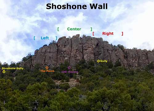
Shoshone Wall Overview
When to Climb
Summer and Fall are the best months to climb. Lost Creek is impassable due to run-off during the Spring, but there are plans to build a foot bridge to open up the crag during this period.
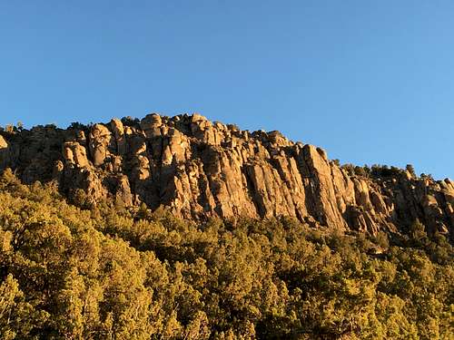
Goshute Wall
Camping
Primitive camping sites are usually available about 1 mile south of the South Nuwuvi Ledge Trailhead.
Parents refers to a larger category under which an object falls. For example, theAconcagua mountain page has the 'Aconcagua Group' and the 'Seven Summits' asparents and is a parent itself to many routes, photos, and Trip Reports.

 1926 Hits
 73.8% Score
 4 Votes