
|
|
Route |
|---|---|
|
|
45.91198°N / 7.03009°E |
|
|
Mountaineering |
|
|
Summer |
|
|
Most of a day |
|
|
5.10b (YDS) |
|
|
TD- |
|
|
10 |
|
|
Overview
One of the first routes in the Monts Rouges di Triolet. It was passed without the use of bolts, but the routes laid later cross the original line, which allows you to use some bolts and ankers. Nevertheless it remains practically clean of gear, for its passage it is required good experience and confident climbing at level 5b.
The line itself is fairly obvious, it passes on the most logical terrain, bypassing most of the steep sections. The climbing is varied. The rocks are granite of good quality. Almost everywhere, except for one pitch, you can organize a reliable belay.
First ascent: Ugo Manera and Enrico Pessiva — 05.08.1979
Approach time: 1.5-2 hours (from the Dalmazzi hut)
Time of the route: 4-5 hours
Descent time to the starting point: 1.5-2 hours
Getting There
From the Dalmazzi hut, take a good trail in the direction of the Triolet glacier. The higher up you go, the worse the trail gets. A little before reaching the glacier, the trail gets lost among the screes and easy slabs. The path is marked with cairns. Out on the glacier, on its flat part, above the icefall. Passage to the glacier is easy. On the glacier to approach under the SW wall of the North peak of the Monts Rouges di Triolet massif (many small crevasses, which are easy to bypass). The last part of the approach (ascent under the SW wall) is quite steep ice slope (up to 40°) with several crevasses. You will need crampons and an ice-axe to overcome it.
The start of the route is to the left of the characteristic couloir limiting the SW wall on the right. The current state of the glacier is such that up to the original start of the route you have to climb simple rocks. The description is given here, taking into account the additional climbing.
The route starts on a comfortable ledge under the steep wall with red spots on the right side of a small bastion in the lower right side of the SW wall.
Route Description
R0-R1 30m 2-3 Along the smooth walls of the bastion, along short walls with ledges, u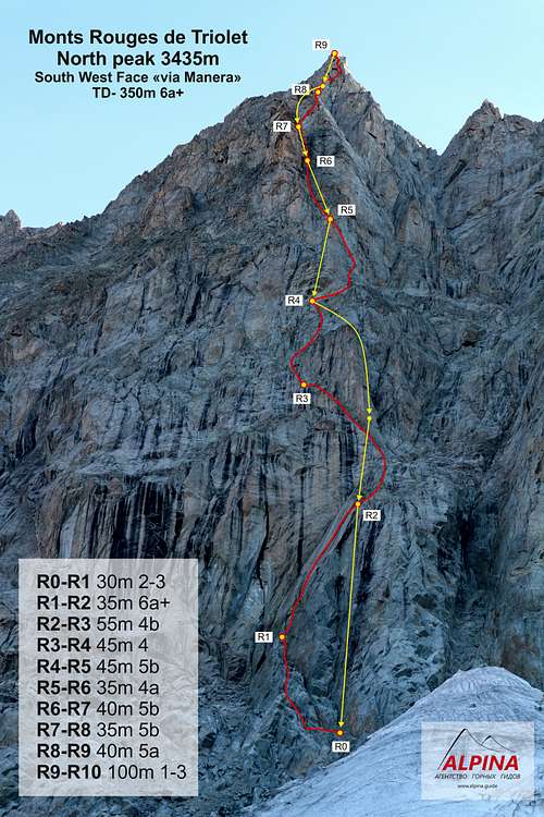 p left to the last ledge under the steep wall with a gap.
R1-R2 35m 6a+ Along the wall with the crack upwards (2 pitons) to a small ledge (10m 6a+). Then along the wide crack up-right behind the bend in the wall (10m 5c). Then along the same crack to its end on a easy terrain (15m 4c). Just above the place where the crack ends on the right there is a anker of the route "Reglette da ballo", here it is convenient to belay a partner.
R2-R3 55m 4b From the anker up along easy rocks to the big terrace under the steep bastion (20m 2). On the bastion you can see the anker of the route "Reglette da ballo". From the terrace to the left, bypassing the bastion, head in the direction of the large flake (15m 3). Go around the flake to the left and reach the ledge above it (15m 4b). Am anker can be set up on the left side of the ledge.
R3-R4 45m 4 From the ledge, in the same direction as the previous pitch, up over the bend. Then turn to the right and along easy rocks out to the top of the bastion (25m 2), which towered above the terrace (see R2-R3). From here left-up along short walls under monolithic overhanging rocks (20m 3-4). Under the cornices is a big ledge, here is the anker of the route "La fond de l'air".
On this section it is difficult to organize the belay.
R4-R5 45m 5b From the anker to the right up over the bend to the big ledge (20m 3). From there along the leftmost crack up-right (piton) to the place where the thin crack turns into a wide one and changes direction, going straight up. Move up the crack to the end of it (25m 5b). Towards the top the crack widens to a small chimney and ends. Here on the left is a small ledge and a anker of the route "La fond de l'air".
R5-R6 35m 4a From the anker on the big corner-couloir upwards (25m 2-3, a lot of loos rocks). Higher the angle becomes steeper, continue up to the place where the angle becomes more steeper and changes to a wide chimney (10m 4a). Here is a small ledge. There is a anker on two pitons, you can improve it with your own points.
R6-R7 40m 5b From the ledge on the right side of the chimney up to its end (25m 5b). Then on easy broken rocks out to the rocky saddle, then come under the base of the monolithic wall with many flakes (15m). At the base of the wall there is a anker of the route "La fond de l'air".
R7-R8 35m 5b From the anker up the wall to the bolt (8m 4b). From it up-right along the flakes to reach the edge of the buttress (15m 5b). On it up to the big horizontal terrace, which forms the shoulder of the buttress (10m 3). The anker is under the base of the next steep rise of this buttress.
R8-R9 40m 5a From the shoulder up to the bolt, then to the anker of the route "La fond de l'air", from it up to the next bolt (7m). From it traverse to the right behind the bend to the base of the corner (7m). At the corner up to the end of it (10m) again go to the edge of the buttress. Here on the big stone, on its left side, is a anker of the route "La fond de l'air". From it along the corner on the right side of the buttress up to its end, then a little more up under the monolithic wall of the buttress, go around it on the left and reach a ledge with big blocks on the left side of the buttress (15m). Here the anker is on your gear.
Above, on the monolithic rib of the buttress, the anker of the route "La fond de l'air", but it is not convenient to belay a partner on it.
R9-R10 100m 1-3 Along the ledge forward to its end (10m), then up-right to the buttress (10m 3). Go to its right side and moving on big blocks upwards go around a small gendarme on the right.
Then by easy rocks on the left side of the buttress go around the summit tower and climb it from the left side (15m 3).
Descent
The descent is partly along the route of the ascent, partly using the ankers of the neighboring routes.
From the summit return to anker R9. From here abseil 45m, using the anker of the route "La fond de l'air", to the anker above the shoulder (see R8-R9). From it the abseiling 40m to anker R7. Then abseiling 40m into the chimney to the anker R6 (on pitons). Then 2 abseilers 35m each at the ankers of the route "La fond de l'air" (R5 and R4). From anker R4 abseil 55m to the "Reglette da ballo" on the bastion (see R2-R3). From there the abseil is 25m to anker R2. From R2 abseil 50 m to the ledge at the start of the route (R0).
Essential Gear
- Rope 2x60m
- Set of friends 7-8pcs (additionally it is recommended to duplicate the middle sizes)
- 5-7 nuts of small to medium size
- 8-10 slings 60cm
- 2 slings 180cm (for the ankers)
- Crampons and ice-axe for approach