
-
 16820 Hits
-
 76.91% Score
-
 8 Votes
|
|
Route |
|---|---|
|
|
46.44170°N / 13.66070°E |
|
|
Download GPX » View Route on Map |
|
|
Hiking |
|
|
Summer, Fall |
|
|
Half a day |
|
|
Medium hard hike up (T3) |
|
|
Introduction
The Normal Route goes from Mangart Saddle on top by the northern, Italian side of Mangart summit dome. But this route should not be mixed with the Italian Ferrata. The latter comes over the North Wall from Mangart valley and joins the Normal Route before the start of the Big Ledge.
The Normal Route uses a broad ledge (see the picture left), which cuts the summit slope all the way to the East Ridge. There it turns right and climbs on top. The route is very panoramic.
General Information
Difficulty: It's a medium hard hiking tour. Most of it goes by a good path, but some sections climb also over easy rocks. Some are secured by pegs and cables, on more demanding sections additional care is required. On the Swiss Hiking Scale its difficulty is graded T3.
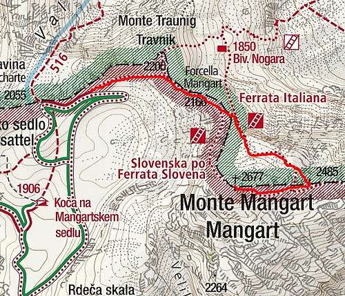
Orientation: It's easy, from the very beginning to the top we can follow the usual red-white marks. Maps to be recommended: Tabacco No. 19. 1:25.000. Planinska zveza Slovenije: Mangart - Jalovec. 1:25.000. See also the GPX track in the header!
Slopes Orientation: The first sections are west oriented, the big band is on the northern side of the summit dome and the summit ridge is east oriented.
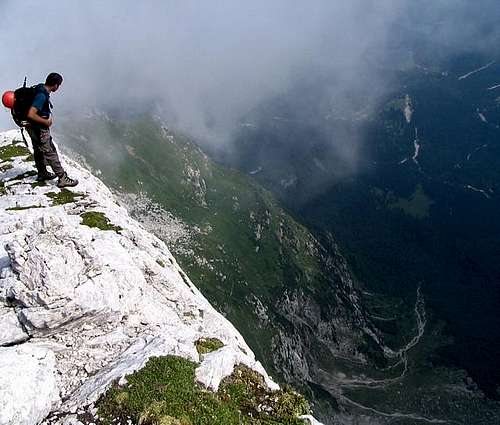
Exposition: There is no big immediate exposition on the path, only some short sections are more exposed. But generally, the exposition of the Big Ledge is huge. It is broad, but goes just above the huge North Wall, which is many hundreds meters tall.
Objective dangers: The biggest objective danger is in early summer, when the Big Ledge may still be under snow.
Best season: Summer months, normally from July till October (or first snow). Again, if the Big Ledge is covered with snow, you need at least ice pick.
Gear: Good shoes and poles are sufficient in summer.
Tour start: The end of the road on Mangart Saddle, or by the Mountain hut, 1908 m. See the parent page how to drive up there!
Highest point: 2679 m.
Altitude to overcome: cca 775 m.
Time for ascent: 2 h 15 min.
Route Description
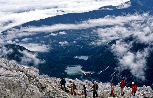
 andreaperino - the view from Normal Route into the valley
From the parking place we go northwards across nice grassy slopes, until reaching Mangart Saddle (the main ridge). From there we continue eastwards, using a comfortable marked path. It crosses the slopes of Travnik, then reaches the rocks of Mali Rateški Mangart, and then climbs over easy rocks on a saddle east of that summit. From this place you have a great view down on the lakes, into the abysses of North Wall and on ferrata, which climbs into the North Wall nearby. Soon after this place there is a path branching.
Slovenian Route goes right into the West Wall, while our (Italian) route continues left, crosses a short scree field and climbs over a rocky step. So we reach the start of the Big Ledge. Then the path continues across the northern slopes towards the east. It ascends only gently. Some 150 m right above us is the summit, many hundred meters left below us are the abysses of North Wall. A few sections on the path are secured, but generally passages are easy. So the path brings us on the East Ridge, where we turn sharp right.
The summit ridge is also not very steep and is quite easy to scramble up. We pass the fore-summit and soon reach the highest point.
On the descent, some care is needed on the place, where the path leaves the East Ridge and descends into the northern slopes. We should not go off the ridge too early, by the highest, false passage. Follow the marks carefully!
Skiing
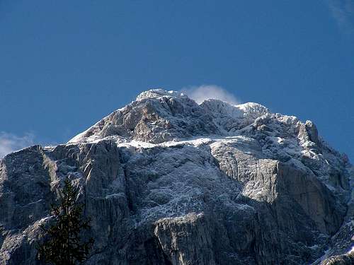
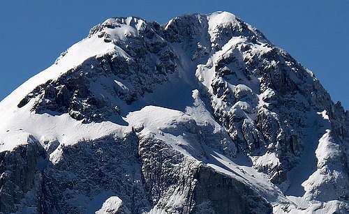 Mangart from the north in winter
Mangart is not a mountain for normal tour skiers. People however quite often ski from the very summit on Mangart saddle, but all the descents are difficult alpinistic tours, very steep, exposed and requiring good snow conditions. Usually not the whole Big Ledge is crossed. Climbers go from it directly up towards the summit, choosing different passages. And so there are also some more options to ski down by those passages. The picture left illustrates them.