

Scott - Mar 9, 2005 11:04 am - Hasn't voted
Very nice photoVery informative too.

PellucidWombat - Mar 9, 2005 11:30 am - Hasn't voted
Re: Very nice photoThanks! Later this winter/summer I'm hoping to find routes up to all of the northern summits. I think that could make for a fun route page.
BTW, since Mount Olympus is the thrown of the gods, and it has many summits, do the individual summits have names of different Greek gods? If not, I wonder if I might take the liberty of naming them once I've climbed them all?!
Scott - Mar 9, 2005 1:30 pm - Hasn't voted
Re: Very nice photoThe Couloirs on the north face have Greek god names. The first I heard of the names was when the Chuting Gallery came out, and don't know how much the names were used before then. We always called them something different.
The smaller couloirs on the east faces are known collectively as the Memorial Couloirs, but I don't know what the biggest one is called (the one that joins with the Tolcat Couloir on the west face).
I think all the summits might make a fun route page. Since I never thought of them as individual peaks, I wouldn't know how many there are or how many I've been up. Probably only four or five.
Anyway, have you ever done Triangle Peak? Do you think it could be the least visited peak (point) in the Wasatch?
PellucidWombat - Mar 9, 2005 4:50 pm - Hasn't voted
Re: Very nice photoI haven't been there yet, but when I do Wildcat Ridge this summer, I intend to make a detour to the summit. I bet that it is the least visited peak/point in the Wasatch considering that it doesn't really have a name and is certainly the most isolated point. N & South Thunder Mountain are pretty remote, but they're still pretty close to a maintained trail over farily easy terrain compared to Triangle.
Any idea if those Memorial Couloirs could make good climbing routes?
I'll check with some of the outdoor gurus at BD & IME to see if they're aware of any local nicknames - if not, then I guess I can take it upon myself to name them in the spirit of Olympus!
Scott - Mar 9, 2005 5:38 pm - Hasn't voted
Re: Very nice photoAny idea if those Memorial Couloirs could make good climbing routes?
They look great, and I've seen them upclose from Thomas Fork and Wildcat, though I've never done them. I've also been through the main Tolcat/East Gully. The catch: Bushwacking in North's Canyon to get to them. When I was there, the brush was extra nasty. This was over a decade ago, and with all the increased use the Wasatch is seeing, maybe a path has developed, but check out lower Norths before planning on anything.

MrWasatch - Mar 9, 2005 5:35 pm - Hasn't voted
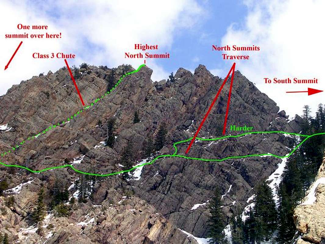
Great picture!Mark, First - this is a great picture of North Olympus from an angle I've never seen before. Second, you show the dotted line as class 3, but what class would you say is the solid green lines traversing towards that route?
I would tend to agree that Triangle or North Thunder would be the least visited peak. Some other possible contenders I came up with - Middle Nebo, Provo Peak's 11,044 foot east peak, any of the various un-named peaks between Monte Cristo and Dromedary (if you count them as seperate peaks). What about North Timp, how often is that one summitted?
PellucidWombat - Mar 9, 2005 6:25 pm - Hasn't voted
Re: Great picture!What about North Timp, how often is that one summitted?
Well, if all goes well this spring with my wish list, a lot ![]()
The solid line showing the traverse is class 3, but if you take the upper variation, it is a class3+ to class 4 downclimb to the main ledge, so its best to not cut over too early unless you want more climbing!

byates - Dec 22, 2008 2:31 pm - Voted 10/10
Easier routeDrop the Chute South of the North peak high summit, to the second tree in photo drop to second gully from there,(a crack, the friction to left) traverse to next rib maintaining elevation to catch drawn route.


Comments
Post a Comment