
-
 6817 Hits
-
 77.48% Score
-
 8 Votes
|
|
Route |
|---|---|
|
|
38.80130°N / 104.8962°W |
|
|
Hiking |
|
|
Spring, Summer, Fall, Winter |
|
|
Half a day |
|
|
Class 1 walk-up |
|
|
Overview
 Mays Peak comes into view to the north as you ascend High Drive
26 Dec 08
The Mays Peak Trail is a gentle option to bushwacking and route-finding from High Drive. No need to tear up the mountain off-trail, skin your shins on deadfall or fight an uphill slog through the dreaded Pikes Peak gravel; there is a smooth trail up this mountain that gradually gains elevation to the summit. This route is a great option for out-of-towners and the little ones.
Mileage: 3.2 miles roundtrip
Elevation Gain: 710 ft.
Getting There
From I-25 in downtown Colorado Springs, exit onto Tejon Street. Take Tejon Street south, passing under I-25. Turn west on Cheyenne Boulevard. Fork to the right onto North Cheyenne Canyon Road, entering North Cheyenne Canyon Park. Follow this narrow, scenic road as it climbs up tight switchbacks. Cresting a ridge and arriving at a flat area, the road turns to dirt, and several roads converge. These roads are High Drive, Cheyenne Canyon Road and Gold Camp Road. Park in the large dirt lot.Route Description
 Click map image to enlarge
- The first mile of your hike will follow High Drive. High Drive starts at a gate on the east side of the parking lot.
- Note that High Drive is open to one-way motor vehicle traffic in the summer months but is closed to motor vehicles in the winter. In the warmer months, do not be tempted to cut mileage off of your hike by driving further toward Mays Peak in your standard size vehicle. There is no guarantee of parking further along High Drive and, as it is a one-way thoroughfare, you will get stuck on the road with little chance to turnaround for quite some time.
- High drive climbs gradually, snaking to the north and eventually reaches a saddle or pass-like flat area. Look for the old stone “High Drive” sign to your left.
- At this pass, turn with your back to the “High Drive” sign and look for a faint, unmarked trail in the southeast corner of this pass, heading southeast. This is the Mays Peak Trail.
- The trail follows a gentle grade, heading first east then swinging north around the mountain, counterclockwise, in a corkscrew fashion.
- On the north side of the mountain the trail turns sharply south (on your left) and heads directly to the flat, mostly-open summit of Mays Peak.
- Trekking pole(s)
- Sturdy hiking boots with grippy soles and stiff ankle support
- Water and snacks
- First aid kit
- Other standard backcountry essentials
- Winter: Gaiters and snowshoes, especially for the north-facing reaches of the trail near the summit
This is a delightful place to enjoy a snack, wonderful views and surprising solitude.
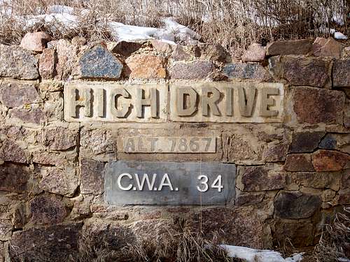 Historic High Drive Sign
Turn your back to this sign and look for the faint trail to the southeast.
26 Dec 08
Essential Gear
 Looking west-northwest from Mays Peak.
26 Dec 08
 Looking north from the Mays Peak summit.
26 Dec 08