
-
 12019 Hits
-
 81.18% Score
-
 13 Votes
|
|
Mountain/Rock |
|---|---|
|
|
38.09580°N / 119.8163°W |
|
|
Hiking |
|
|
Spring, Summer, Fall |
|
|
8096 ft / 2468 m |
|
|
Overview
Mercur Peak is a granite prominence found near Styx Pass along Kibbie Ridge, an otherwise low-elevation, mostly forested ridgeline that straddles the border between northwestern Yosemite and the Emigrant Wilderness. Although not the highest point along the ridge, the peak--the exfoliated remains of a dome from eons past--affords excellent views over the spectacular Cherry Creek Canyon to the north, as well as Lord Meadow, Bartlett Peak, and the higher peaks of Emigrant/Yosemite to the south and east.Given its relative obscurity, few parties will plan a trip around a visit to Mercur Peak. However, it is a justifiably popular ascent for hikers in the area, particularly those headed for Cherry Creek Canyon, with an effort-view ratio that is well worth the short detour from the trail. The generally lower elevation of the region also makes it a fine destination for those looking for an early season Sierra fix.
 |  |
Routes Overview
The peak has any number of possible walk-up routes on the gentle south and west slopes, and some more interesting scrambling possibilities on the steeper east and north faces.West Slope. This is the easiest route up the peak. From the small saddle just west of Mercur Peak, stroll up granite blocks--a perfect natural staircase!--that lead up to the summit.
South Slopes. The south slopes are easy class 2; one can either ascend low-angle friction slabs directly to the summit, or follow a gully up to the shallow saddle between the western and eastern summits. The western summit is the higher of the two.
East Face. One may be tempted to take a short-cut on the way down, particularly if heading for Lord Meadow or Cherry Creek Canyon. However, as is the case with many peaks in this area, the east face of Mercur Peak features many 10- to 20-foot cliffs amongst otherwise gentle terrain that greatly complicate route-finding, and it may take considerable effort to keep any descent route to class 3 or less. (In fact, I was unsuccessful in such an endeavour, and had to backtrack to the south slopes).
North Face. The north face of Mercur Peak is much steeper than the other sides, and seems to feature a number of plausible class 3 routes on excellent rock. One should use caution in using these as a means to access Cherry Creek Canyon; the canyon features some steep cliffs in this section, none of which can be seen from the summit, and a party could easily find itself cliffed out even when seemingly safely off the peak. Descending to the trail and continuing around via Lord Meadow is a more sure bet.
 |
Getting There
The peak is most easily reached from the Kibbie Ridge trail.The Kibbie Ridge trail begins at Shingle Springs, which itself is reached from Cherry Lake--in actuality, a dam of Cherry Creek, courtesy of Hetch Hetchy Water & Power. Cherry Lake is reached via a well-signed, scenic 24-mile drive from Highway 120 through Sierra low country, which can be especially pleasant in spring when wildflowers are blooming. The turn-off for the lake (Cherry Road, Forest Service road 17) is located 13.6 miles east of Groveland, just past a bridge over the South Fork Tuolumne River.
From Cherry Lake, pass over the dam on a gravel road, following signs for the Kibbie Ridge trailhead. Follow the road to its end at Shingle Springs; the road becomes progressively poorer the further you drive, with the last couple of miles being a rough dirt road. This is passable to most passenger cars, but if yours is the exception, parking is available in several spots along the road up to that point.
Red Tape
A wilderness permit is required for overnight stays. This can be picked up from the Groveland Ranger District office, located on the south side of Highway 120, roughly eight miles east of Groveland.Although the Kibbie Ridge trailhead is signposted as belonging to the Emigrant Wilderness, the trail skirts the Yosemite park boundary and is subject to usual Yosemite trailhead quota requirements; the quota here is 25 per night as of June, 2003. Most of this quota is intended to assuage overuse in Kibbie Lake, and I'm informed by a ranger that even if quotas are met--in my experience, highly unlikely, even on holiday weekends--the tendency is to be somewhat liberal in giving out permits if you say that your eventual destination is the Styx Pass area/cross-country.
When To Climb
The road to Shingle Springs is generally open May through September. At other times of year, you will have to park at Cherry Lake, adding another five miles or so on to your hike. Because of the low elevation, summer months can be hot, so early season (May/June) is probably the best time to visit. This makes a fine early season hike when the higher elevations of the Sierra are still snowbound.Camping
Possible campsites may be found in the vicinity of Styx Pass, where several small tarns grace the granite landscape. Otherwise, good camping is found along the East Fork of Cherry Creek in Lord Meadow, a fairly short descent from the pass.Camping outside the wilderness can be found at Cherry Lake, at the Cherry Valley campsite. More information about this can be found from Stanislaus National Forest.
Mountain Conditions
Current conditions may be found from Yosemite or the Stanislaus National Forest conditions page. In general, though, your best bet for up-to-date information is to call the Groveland Ranger District at (209) 962 7825.Snow information for Kibbie Ridge can be found at the CDEC website. Note that the Lower Kibbie Ridge station (6700 ft) tends to become snow-free roughly 1-2 weeks earlier than much of the rest of the ridge higher up. The Sasche Springs station (7600 ft) is a better predictor, but this data is collected manually once a month.
Because of its relatively low elevation, this region tends to be snow-free fairly early in the season. During early season trips (May/early June), you'll likely encounter some snow along the forested trail leading up to Styx Pass, but the peak itself and the surrounding granite expanses will often be largely snow-free even by this time.
Recent trail conditions for the Shingle Springs area may be found in the Stanislaus National Forest trailhead status report.
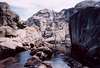
Cherry Creek Canyon
The highlight of this area is undoubtedly Cherry Creek Canyon, a pristine area of untrailed granite, domes, and water that may be unrivaled in the entire Sierra. It is a beautiful, wild, and truly spectacular setting. Schifrin's Emigrant Wilderness guidebook contains a detailed description of the canyon descent. For anyone who enjoys cross-country hiking or moderate scrambling, the route is a must-do at some point. I won't duplicate the details of the route here--they are documented thoroughly over several pages in Schifrin's book, and the route-finding is a large part of the fun in this canyon anyway--but will mention only that his description is worth following if you have a tight schedule to keep--ignoring it and sticking close to the creek as the gorge narrows leads to more fun in the short term, but also more time backtracking and getting back on route in the long term. Do not underestimate the time required to make your way down the canyon on a first descent!One may also be tempted to descend the canyon during spring run-off--it's certainly a project that ranks highly on my to-do list--but this should be attempted only in the knowledge that it is much harder than later in the season. In early season, Cherry Creek is more akin to a river; the usual creek crossings to keep to the easiest route are impossible, and one is left with no choice but to cross steep, slick slabs with a short run-out that leads straight into the raging creek. It may be possible to bypass these via the drainage west of Mercur Peak, but I haven't explored this variation yet; this would also bypass the most spectacular part of the canyon. The steep slabs along the creek can also be bypassed by more exposed class 3 slabs higher up, but these can also often be very slick with run-off in the spring.
In addition to the usual exit near the end of the canyon, several parties have reported various entries/exits in the vicinity of Lookout Point, bypassing the last couple of miles of (reportedly less scenic) low country in the canyon in favour of following drainages up to/down from Kibbie Ridge. Some truly heinous bushwhacking can be encountered around here; these variations on Schifrin's route may be a reasonable option only in early season when snow still lingers.
A final comment: As if all this didn't sound fun enough, if you descend the canyon, long pants and/or a snake bite kit are highly advisable. You're almost assured of encountering a rattling snake or two hidden in the thick brush along the creek.
 |
Etymology
"James Mercur (1842-1896), professor of engineering at West Point from 1884 until his death. (Heitman, 703.) The peak, on the park's northwest boundary, was named in 1912 by Col. Forsyth. (Farquhar: Benson.) The name appeared on the third edition of the Dardanelles 30' map, 1912."- Peter Browning, Yosemite Place Names