
|
|
Area/Range |
|---|---|
|
|
37.18378°N / 108.48869°W |
|
|
Hiking |
|
|
Spring, Summer, Fall, Winter |
|
|
8572 ft / 2613 m |
|
|
Overview
 Mesa Verde
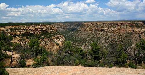
Mesa Verde (meaning “green table”) is one of Americas premier scenic and historic parks. Located in extreme southwest Colorado near the Four Corners, Mesa Verde rises over 1,000 feet from the Mancos Valley. Covered by Pinyon-pine forest (see Fires of 1996-2004), cut by deep canyons, and home to some of the most ancient archaeological sites in the United States Mesa Verde is truly a place without comparison in America. Within its 52,000+ acres are no less than 4,000 archaeological sites which include some 600 cliff dwellings! Therefore, due to its priceless historic and cultural value, much of the park remains off-limits to the thousands of visitors who invade it each year. Hiking is restricted to 20-or so miles of trail and rock climbing (to the dismay of some on SP I’m certain) is prohibited. Despite the lack of outdoor recreation in the park I still thought Mesa Verde was quite deserving of a place on Summitpost…
Geology
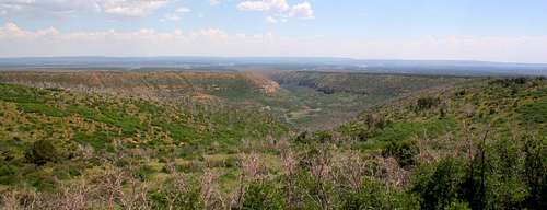
 North Rim
Mesa Verde was born out of the waters of a great inland sea that covered the area 85-100 million years ago. As the waters advanced and grew deeper successive layers of sediment were laid down forming the various layers of sandstone and shale seen on the mesa today. Typically the lower elevations are comprised of shale while the upper elevations, including where most of the cliff dwellings are located, are predominately sandstone. The sandstone was laid down during an extended period when the seas were quite shallow, barely covering the landscape. Evidence of this is shown through the condition of some fossils left in the sandstone. Many of them have been broken due to wave action that took place during this period. Eventually, during the late Cretaceous Period, the region experienced a long period of uplift which drained the seas and exposed the landscape to erosion giving us the landscape we see in the area today.
Early Human History
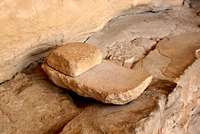 Grinding Stone
As best we can determine humans began to settle at Mesa Verde around 550 AD. Now referred to as “Ancestral Puebloans,” these peoples lived atop the mesa in clusters of pit houses and lived a life farming, hunting, pottery-making, & basketweaving. For 200 years they lived this way until, around 750 AD they began to construct their homes above ground in more traditional-styled walled homes made from mud & wood collected atop the mesa. The houses were typically built together, curving around a central pit-house which many believe were precursers to the kiva’s of the later cliff dwellings. Eventually, as their skills increased, the homes began to be built from cut stone. By the year 1000 they were building multiple-storied homes containing as many as 50 rooms! For another 200 years the Ancestral Puebloans continued to farm and thrive until, for some unknown reason, they decided to change they’re lifestyle radically in the years leading up to 1200 AD.
 Ancient Flooring
Archeologists have speculated for decades why the Ancestral Puebloans decided to leave their mesa-top homes and move out into the cliffs. The most obvious reason may have been for defense, though shelter or religion could have influenced them as well. Whatever the cause, starting around 1190 AD the native peoples began one of the most ambitious and unique construction projects in history. During the following century the Ancestral Puebloans constructed hundreds of cliff dwellings ranging in size from one room homes to the dazzling 200+ rooms at Cliff Palace. They spared no effort in the construction either as is evidenced by the finely plastered and painted walls still visible in many rooms to this day. Though this was their greatest achievement, the Ancestral Puebloans stayed in the cliff dwellings for barely one hundred years. For some baffling reason by 1270 they had begun to move out and by 1300 AD Mesa Verde sat deserted. Was it crop failures? Lack of game? Social upheaval? No one knows exactly. Moving south-west these peoples settled in present day New Mexico and Arizona where their descendants, the Pueblo’s and perhaps other tribes, live today.
Modern History
Mesa Verde was first visited by the white man in the year 1859. A geologist named Prof. J.S. Newberry climbed atop the mesa and gave the place its modern name. Unfortunately for him, he missed seeing any of Mesa Verde’s ancient dwellings. Some fifteen years later the area had been more extensively explored by trappers and miners. Word of strange dwellings amongst the cliffs started to make their way back east. In 1874 a number of dwellings were for the first time photographed and explored. Rumors of studies and excavations in the area spread but never came to fruition though the area started to become frequented by tourists and looters. Sun Point
In 1906, after a number of unsuccessful attempts, congress finally passed the necessary bill, which President Theodore Roosevelt quickly signed, and Mesa Verde National Park was born. Within a couple of years excavation and restoration was begun and visitors facilities were erected within the park. Today this work continues. Much work continues to be done in areas of the park that visitors never see. It is an ongoing struggle to balance tourism and preservation of these historic treasures.
Natural History & Climate
 Cliff Canyon Snow
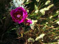 Hedgehog Cactus
Despite the barren feel to the land, the Pinyon-pine forests (see Fires of 1996-2004), cliffs, and alcoves of Mesa Verde are a haven to a large number of plants and animals. Instead of trying to write them all out here I decided to copy a list provided by the park service educational brochure…
Common Mammals:
 Coyote
| Badger, Taxidea taxus California Bat, Myotis californicus Fringed Bat, Myotis thysanodes Hoary Bat, Lasiurus cinereus Long-legged Bat, Myotis evotis Spotted Bat, Euderma maculatum Yuma Bat, Myotis yumanenis Black Bear, Ursus americanus Ringtail Cat, Bassariscus astutus Golden-mantled G. Squirrel, Spermophilus lateralis Colorado Chipmunk, Eutamias quadrivittatus Desert Cottontail, Sylvilagus audubonii Mountain Cottontail, Sylvilagus nuttallii Coyote, Canis latrans Mule Deer, Odocoileus hemionus Red Fox, Vulpes vulpes Gray Fox, Urocyon cinereoargenteus Blacktail Jackrabbit, Lepus californicus | Mountain Lion, Felis concolor Yellow-bellied Marmot, Marmota flaviventris Deer Mouse, Peromyscus maniculatus Plains Pocket Mouse, Perognathus flavescens Western Harvest Mouse, Reithrodontomys megalotis Muskrat, Ondatra zibethicus Western Pipistrel (bat), Pipistrellus hesperus Porcupine, Erethizon dorsatum Whitetailed Prairie Dog, Cynomys gunnisoni Raccoon, Procyon lotor Masked Shrew, Sorex cinereus Merriam Shrew, Sorex merriami Striped Skunk, Mephitis mephitis Rock Squirrel, Citellus variegatus Tassel-eared Squirrel (Abert Squirrel), Sciurus aberti Longtail Weasel, Mustela frenata Mexican Woodrat, Neotoma mexicanus Whitethroat Woodrat, Neotoma albigula |
Common Birds:
| Brewer’s Blackbird, Euphagus cyanocephalus Mountain Bluebird, Sialia cuttucoides Mountain Chickadee, Parus gambeli Mourning Dove, Zenaida macroura Golden Eagle, Aquila chrysaetos Rosy Finch, Leucosticts arctoa Northern Flicker, Colaptes auratus Ash-throated Flycatcher, Myiarchus cinerascens Blue-gray Gnatcatcher, Polioptila caerulea Black-headed Grosbeak, Pheucticus melanocephalus Red-tailed Hawk, Buteo jamaicensis Sharp-shinned Hawk, Accipiter striatus Broad-tailed Hummingbird, Selaphorus platycercus Pinyon Jay, Gymnorhinus cyanocephalus Scrub Jay, Aphelocoma coerulescens Steller’s Jay, Cyanocitta stelleri Gray-headed Junco, Junco hyemalis American Kestrel, Falco sparverius Black-billed Magpie, Pica pica | White-breasted Nuthatch, Sitta carolinensis Great Horned Owl, Bubo virdinianus Common Poor Will, Phalaenoptilus nuttallii Common Raven, Corvus corax American Robin, Turdus migratorius Pine Siskin, Carduelis pinus Townsend’s Solitaire, Myadested townsendi Chipping Sparrow, Spizella passerina Violet-green Swallow, Tachycineta thalassina White-throated Swift, Aeronautes saxatalis Western Tanager, Piranga ludourciana Juniper Titmouse, Parus inornatus Rufous-sided Towhee, Pipilo erythrophthalmus Wild Turkey, Meleagris gallopavo Turkey Vulture, Cathartes aura Black-throated Gray Warbler, Dendroica nigescens Yellow-rumped Warbler, Dendroica coronata Hairy Woodpecker, Picoides villosus Canyon Wren, Catherpes mexicanus |
Common Reptiles:
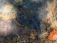 Plateau Striped Whiptail
| Bullsnake, Pituophis melanoleucus sayi Collared Lizard, Crotaphytus collaris N. Plateau Lizard, Sceloporus undalatus elongatus | Sagebrush Lizard, Sceloporus graciosus Yellow-bellied Racer, Coluber constrictor mormon Prairie Rattlesnake, Crotalus viridis viridis |
Common Flowers, Trees, & Shrubs:
 Snapdragon
| Aster, Aster bigelovii Prickly Pear Cactus, Opuntia polycantha Scarlet Gilia, Gilia aggregata Globemallow, Sphaeralcea coccinea Larkspur, Delphinium nelsonii Mariposa Lily, Calochortus nuttallii Lupine, Lupinus sericeus Indian Paintbrush, Castilleja linariaefolia Scarlet Penstemon, Penstamon bridgessi Evening Primrose, Oenothers caespitosa Cliff Fendlerbush, Fendlera rupicola Douglas Fir, Pseudostuga menziesii | Utah Juniper, Juniperus utahensis Mountain Mahogany, Cerocarpus montanus Pinyon Pine, Pinus edulis Ponderosa Pine, Pinus ponderosa Mormon Tea, Ephedra viridis Gambel Oak, Quercus gambelii Rabbitbrush, Chrysothamnus nauseosus Big Sagebrush, Artemesia tridentata Utah Serviceberry, Amelanchier utahensis Skunkbush Sumac, Rhus trilobata Snowberry, Symphoricarpos oreophilus Broadleaf Yucca, Yucca baccata |
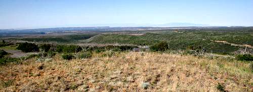
The North Rim
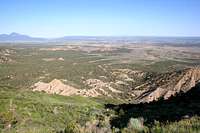 Montezuma Valley
The North Rim is the scenic 15-mile route of entry into the park. From the park entrance the road quickly winds its way up to the top of the mesa as it heads south towards Far View. Though there are few historic sites in this section, this is where the greatest natural wonders of the park are on display. Numerous cliff top overlooks, the parks highest point (Park Point-8427’), canyons, some nice hiking trails, and Morehead Campground are located here…
 Knife Edge
Hiking Trails
- Knife Edge Trail (2 miles) - Begins at Morefield Campground. The trail follows a section of the old park access road up the north rim. Offers awesome views of the Montezuma Valley.
- Park Point Overlook Trail (1 mile) - A short hike up to Park Point, the highest point in Mesa Verde at 8427'. The overlook neighbors a modern fire tower and commands 360-degree views of the park.
- Point Lookout Trail (2.2 miles) - Begins at Morefield Campground. Possibly the most beautiful trail in the park. The path tops out atop 8427' Point Lookout with sweeping views across the Maontezuma and Mancos Valley's almost 2000' below.
- Prater Ridge Trail (7.8 miles) - Begins at Morefield Campground. A pretty ridgetop hike providing views of the Montezuma Valley, Prater Canyon, and Morefield Canyon.
 Park Point - 8572'
Chapin Mesa
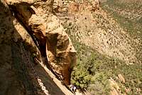
Chapin Mesa is the eastern and most heavily visited of the two historic mesas within the park. There is good reason for this. Literally dozens of sites, from pit houses to cliff dwellings to cliff dwelling overlooks cover this mesa. Three of the parks most treasured sites (Spruce Tree House, Cliff Palace, and Balcony House) are located here. The mesa is located 6-miles south of the Far View Visitors Center and is accessed by two loops. The road is open year-round weather permitting...Historic Sites
| Balcony House A.D. 1180-1270 | Guided - 38 rooms/2 kivas - Sitting 600' above the floor of Soda Canyon this is perhaps the most dramatically placed cliff dwelling in the park. Rangers will not allow anyone "out-of-shape," afraid of heights, or over 250 lbs. on this tour due to the climbs and narrow passages on this tour. | 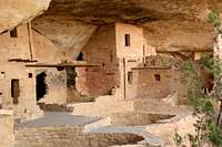 |
| Cedar Tree Tower A.D. 1100-1200 | Self-Guided - The towers of Mesa Verde are still smoething of a mystery. Always adjacent to a kiva, it is assumed they have some religious significance though they could have been used defensively or for communication. | 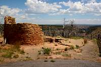 |
| Cliff Palace A.D. 1190-1280 | Guided - 150 rooms/23 kivas - The crown jewel of Mesa Verde was not actually a palace...just a really, really big cliff dwelling that at one time housed upwards of 120 people. The tour of Cliff Palace is deservingly the most popular in the park. |  |
| Far View Ruins A.D. 800-1300 | Self-Guided - This was once the most densely populated location at Mesa Verde. The location was almost continuously occupied for the duration of human habitation at Mesa Verde. As such a walk through this area introduces one to the various stages of development the Ancestral Puebloans achieved. |  |
| Hemenway House A.D. 1200 | Overlook - Viewable from Sun Point Overlook along with almost a dozen other dwellings. Cliff Canyon, in which the dwelling sits, was between A.D. 1200-1300 home to nearly half of Mesa Verde's population. | 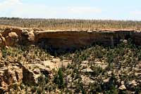 |
| House of Many Windows A.D. 1200 | Overlook - Viewable from an overlook along the Cliff Palace Loop Road. Cliff Canyon, in which the dwelling sits, was between A.D. 1200-1300 home to nearly half of Mesa Verde's population. |  |
| Mesa Top Sites A.D. 900-1100 | Self-Guided - At this location you can see the remains of three different villages built one atop the other during different building periods from wooden dwellings to stone. | 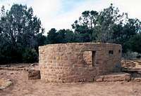 |
| New Fire House & Fire Temple A.D. 1250 | Overlook - New Fire House is located next to Fire Temple. It is believed that Fire Temple was not used as a dwelling but as a gathering place for the surrounding area. | 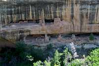 |
| Oak Tree House A.D. 1250 | Overlook - 50 rooms/2 kivas - Viewable from Sun Point Overlook along with almost a dozen other dwellings. Cliff Canyon, in which the dwelling sits, was between A.D. 1200-1300 home to nearly half of Mesa Verde's population. | 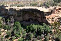 |
| Pithouses A.D. 600-950 | Self-Guided - Before moving into the cliffs the Ancestral Puebloans lived atop the mesa in these pithouses. The site offers an amazing look into the life of pepole who lived here 1300 years ago. |  |
| Spruce Tree House A.D. 1200-1280 | Guided/Self-Guided - 130 rooms/8 kivas - Third largest in the park, this dwelling is open to free-roaming exploration (within set boudaries) and allows the visitor to experince a reconstructed kiva. |  |
| Square Tower House A.D. 1200-1300 | Overlook - 80 rooms - One of the last dwellings built at Mesa Verde the outstanding feature of this structure is its four-story tower...thus the name. |  |
| Sun Point Pueblo A.D. 1200's | Self-Guided - This large pueblo was one of the last built atop the mesa at a time when most residents were moving to the cliffs. |
| Sun Temple A.D. 1250 | Self-Guided - 30 rooms - This structure was likely used for important ceremonies and is very interesting to walk around and peer inside. Commanding an impressive view down Cliff Canyon there is good evidence that the structure was never fully completed. | 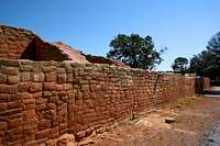 |
Hiking Trails
- Farming Terrace Trail (0.5 mile) - Begins near Cedar Tree Tower. As the name implies, the trail winds its way past numerous farming terraces used by the Ancestral Puebloans.
- Petroglyph Point Trail (2.4 miles) - Begins off Spruce Tree Canyon Trail. This path leads you out to the only trailside petroglyphs in the park. On the way back it gains the top of the mesa with views of Spruce and Navajo Canyons.
- Spruce Canyon Trail (2.4 miles) - Begins near Spruce Tree House. Follows Spruce Canyon up from Spruce Tree House. The trail offers a unique opportunity to explore the bottom of one of Mesa Verde's canyons.
- Soda Canyon Overlook Trail (1.2 miles) - Off Cliff Palace Loop Road. A fairly easy hike leads out to a high overlook above Soda Canyon. The overlook at the end of the trail offers the only cliff top views of Balcony House.
 Soda Canyon
Wetherill Mesa
Wetherill Mesa is the western of the two mesas that are home to most of the historic structures in the park. Of the two mesas Wetherill is the lesser-visited. Wetherill Mesa is reached by turning west onto Wetherill Mesa Road (isn’t that easy?) just past the Far View Visitors Center. The 12-mile road out to the mesa is only open from late May to early September. To visit any of the following sites except Step House one must board a small tram out for the guided tour of Long House and the rest...Historic Sites
| Badger House Community A.D. 650-1280 | Self-Guided - Several stages of Ancestral Puebloan development can be seen along the short trail through this area. |
| Kodak House A.D. 1200's | Overlook - 60 rooms - This two-story structure can be been from Kodak House Overlook along the Wetherill Mesa Road. |
| Long House A.D. 1200-1300 | Guided - 150 rooms/21 kivas - This is the second largest cliff dwelling at Mesa Verde and is situated in an unusually large alcove above Rock Canyon. |
| Nordenskiold Site #16 A.D. 1200's | Overlook - 50 rooms/6 kivas - This cliff dwelling was excavated by Swedish scientist Gustaf Nordenskiold, one of the first to "expertly" explore Mesa Verde. |
| Step House A.D. 1220 | Self-Guiding - Step House is unique in that it shares a site with a basketmakers pithouse fom A.D. 626. No where else in Mesa Verde do two dwelling era's share so close a space. |
Hiking Trails
- Nordenskiold Site #16 Trail (2 miles) - If you want solitude at Mesa Verde this trail might be your best bet! Seldom used, this hiking trail leads out to Nordenskiold Site #16, which is described above.
Visitor Facilities, Tours, & Camping
Visitors Centers
 Far View V.C.
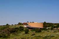
Far View Visitors Center is the primary visitors center at Mesa Verde and is located 15 miles from the park entrance. Anyone visiting for the first time should probably stop here first to get oriented. The center is open seasonally from mid-April to mid-October and houses a bookstore, restrooms, and various native exhibits.
Chapin Mesa Museum is located 5 miles south of Far View Visitors Center at Spruce Tree House. The museum has numerous displays portraying life at Mesa Verde over the centuries as well as a large collection of artifacts. The museum is a good stopping point for those heading out onto Chapin Mesa as it is the only place to get water on the mesa. There are also restrooms, a snack bar, and a bookstore on site.
Guided Tours
 Balcony House Tour
Of the five dwellings you can enter in the park three (Cliff Palace, Balcony House, and Long House) are only accessible by guided tour. The tours are a steal at $3/person and the only places to get ticket are Morehead Campground, Far View Visitors Center, or the Chapin Mesa Museum.
Spruce Tree House has guided tours offered but it is not required for entry and Step House is self-guided only.
Camping & Lodging
- Morehead Campground is a 435-site modern campground found four miles from the entrance station. It is open early May through early October. Though the NPS website states "the campground rarely fills" my guess is that reservations would likely be a good idea. You can contact the campground at 1-800-449-2288.
- Far View Lodge & Terrace are for those looking for more plush accomodations. Located next to Far View Visitors Center the hotel has only basic amenities (no TV's or telephones) and is situated next to Far View Terrace which offers (pricy!)meals for visitors.
Fires of 1996-2004
Between the years 1996 and 2004 some 28,443 acres (55%) of Mesa Verde National Park were burned as a result of lightning strikes. The intensity of the fires were caused by a combination of drought and a century of fire suppression by the park service. I for one was very surprised at the extent of the damage in the park even after a number of years have passed. Particulaly hard hit were the Wetherill, Far View and North Rim Areas. Miles of burned forest are still visible and give the impression that the fires happened much more recent than they did. The mesa is recovering, but slowly due to the arid climate. As far as I know all roads and trails have been re-opened but if you plan on hiking, in the Wetherill Mesa area in particular, I'd recommend calling ahead:1-970-529-4465
Getting There...
Mesa Verde National Park is located off of US-160 between Mancos and Cortez, Colorado. There is only one entrance to the park so its not hard to get to.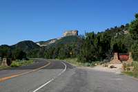 Park Entrance
 Some distances from major nearby cities are...
Albuquerque, NM.........235 miles
Denver, CO..............400 miles
Flagstaff, AZ...........265 miles
Salt Lake City, UT......390 miles
Helpful Links...
Mesa Verde National Park - Official WebsiteMesa Verde National Park - Unofficial Website that's a bit easier to search through.
Geology of Mesa Verde - Produced by the USGS
Fire History of Mesa Verde
Mesa Verde Trails Illustrated Map
DWhike's Adventures - Shameless self promotion...come visit my website for more pics of Mesa Verde NP and other places that I have wandered off to in recent years...

kavak - Oct 30, 2008 5:58 pm - Voted 10/10
Park High PointI really enjoyed your Mesa Verde page, especially the listing of animal species seen in the park. You mentioned the high point as being 8,427 ft, but my topo map reads that it is 8,571 ft.
dwhike - Oct 30, 2008 7:16 pm - Hasn't voted
Re: Park High PointMy bad, typo, Park Point's elevation is marked as 8572' at the trailhead...I'll have to go back through my photos and make sure I didn't screw them up also! Thanks!!