
-
 11309 Hits
-
 89.01% Score
-
 28 Votes
|
|
Mountain/Rock |
|---|---|
|
|
45.69980°N / 6.98870°E |
|
|
Mountaineering |
|
|
9921 ft / 3024 m |
|
|
What's new
 |
Oct 31, 2006 Inherited the page from Gangolf Haub Nov 01, 2006 Up to now, only minor corrections have been made to the original text written by Gangolf, submitter of the page and its previous maintainer.
First Ascents
Punta Meridionale:
- First on the summit: Unknown.
- In winter: Unknown.
- E Wall: Osvaldo Cardellina, Roy Cardellina, Luca Ferronato and Danilo Garzotto, (Aug 05th, 1993), in descent.
Punta Settentrionale:
- N-E Arête (from Colle della Croce): A. Adami, L. Savoye and C. Paradisi, (Jul 17th, 1938).
- N Wall: A. Adami, O. Figerod, A. Piatto and S. Marcoz, (Jun 24th, 1939).
- N-NE Eperon: Osvaldo Cardellina, (Aug 05th, 2002), in descent.
- E Wall (direct line): Osvaldo Cardellina, (Aug 05th, 2002), in ascent.
Overview
With barely more than 3.000m of altitude, Mont Colmet isn't surely one of the more prominent summits of the Valle D'Aosta Region. It belongs to the relatively low but (up to now) heavily glaciated Rutor Group, wedged between Valgrisenche to the East and Val de la Thuile to the West, with Valle d'Aosta bounding to the North. The whole area is relatively unknown and you can enjoy solitary outings among Steinbocks, Chamois' and Golden Eagles. Mont Colmet is the northernmost 3000er of the group and thus commands great views in all directions. Especially interesting is the close-up view into the Rutor Group with Mont Paramont, Testa del Rutor and Grand Assaly dominating the huge Ghiaccaio del Rutor Glacier. The routes to the summit are as lonesome as the summit itself and both are very long. Once you have left the picnic and fishing places near Lago d'Arpy you are virtually on your own. Noteworthy are the ruins of an old fort from the Napoleonic Wars near Colle della Croce. The fort overlooks Val de la Thuile and is the starting point of a war trail which leads directly up to Mont Colmet. As usual with these old war trails the route is designed ingeniously, surmounting each obstacle easily. However nowadays the path is decaying and the multiple iron cables shouldn't be relied upon too heavily. In some places the path has broken away altogether so that some UIAA II climbing is necessary. You'll find another ruined shelter just to the north of Mont Colmet's Summit.
 |
 |
 |
 |
 |
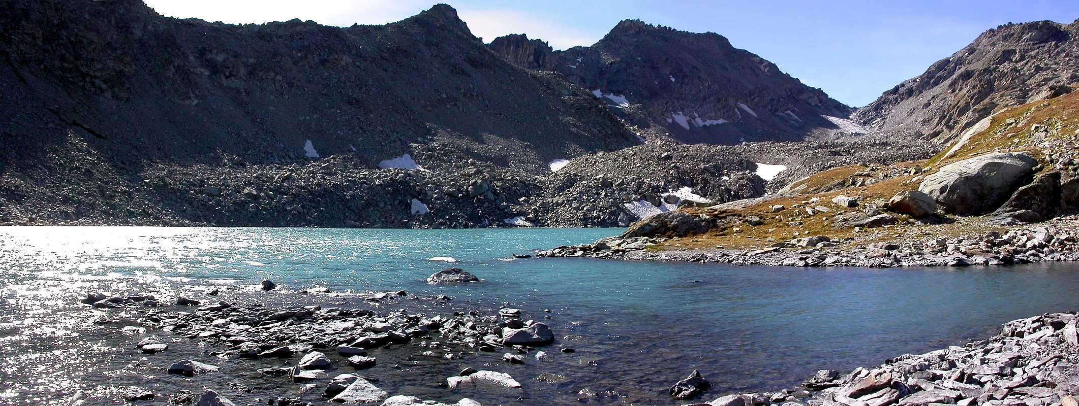
The Lakes
One of the attractions of the Mont Colmet ascent (or descent if you will) are the lakes on the Lago di Pietra Rossa route. It starts at Lago d'Arpy (which is a maze of lakes rather that an only lake and tops at Lago di Pietra Rossa. Look at Antonio's beautiful pictures to get my meaning.
 |
 |
 |
 |
 |
Getting There
From Italy
- Take Motorway A5 from Torino through the Aosta Valley. Leave the Motorway at the exit La Salle and take SS.26 west in direction Courmayeur. Before arriving at Morgex, you turn into a little side road (SR.39) that climbs upwards through larch forests to Colle San Carlo (and eventually leads to La Thuile (and thus in the end to the Colle di Piccolo St. Bernhard). There (at the hotel Genzianella on Colle San Carlo) you can leave your car and start the ascent.
From France
- From Chamonix take the Mont Blanc Tunnel (E25) towards the Italian side. Avoiding to enter the Motorway go along SS.26 east. After Morgex turn on to the side road (SR.39) towards Colle San Carlo.
 |
 |
 |
 |
 |
Red Tape
No red tape. There are warning signs on the old war trail that nobody takes the responsability for any accidents that might happen thereupon. Take care, the cables are rusty and loose. At one point the whole path is broken away.
 |
 |
 |
 |
When To Climb
The best time for climbing Mont Colmet is late June through early October. Winter ascents using tour skis are possible by taking the Lago di Pietra Rossa route. Don't even think of taking the war trail route.
 |
 |
 |
 |
 |
Mountain Conditions
- Meteo: you can find all the needed informations at the official site of the Valle d'Aosta Region:
- Valle d'Aosta Meteo
Webcam
- WEBCAM on Aosta Valley:
- Webcam
Books and Maps
BOOKS:
- "Guida dei Monti d'Italia – Alpi Graie Centrali" di Alessandro Giorgetta - Club Alpino Italiano/Touring Club Italiano, (1985), in Italian,(384 p. with maps and pics).Thanks to Claude Mauguier for pointing out this book.
- "Valdigne gli itinerari escursionistici" di Alessandro Giorgetta Ed. Zanichelli, (1981), in Italian.
- "Diari Alpinistici" di Osvaldo Cardellina e Indice Generale accompagnato da Schedario Relazioni Ascensioni 1964-2019 (inediti).
MAPS:
- Kompass, "Massiccio del Monte Bianco Valle d'Aosta" Sentieri e Rifugi" Carta turistica 1:50.000.
- Kompass, "Gran Paradiso Valle d'Aosta, Sentieri e Rifugi" Carta turistica 1:50.000.
- L'Escursionista "La Thuile-Piccolo San Bernardo" (n° 2) 1:25.000.
- Enrico Editore Ivrea-Aosta, "Gruppo del Gran Paradiso" 1:50.000.
- I.G.M. Istituto Geografico Militare Maps. 1:25.000.
- Hapax "Mont-Blanc Les sentiers", Comunità Montana Valdigne Ed. 2001 1:50.000.
Important Information
- REGIONE AUTONOMA VALLE D'AOSTA the official site.
- FONDAZIONE MONTAGNA SICURA Villa Cameron, località Villard de la Palud n° 1 Courmayeur (AO) Tel: 39 0165 897602 - Fax: 39 0165 897647.
- COMPAGNIE DES GUIDES RUTOR Fraz. Entrèves tel/fax 0039.0165.885574 e-mail Guidealpine@lathuile.it
- A.I.NE.VA. (Associazione Interregionale Neve e Valanghe).
Useful Numbers
- Protezione Civile Valdostana località Aeroporto n° 7/A Saint Christophe (Ao) Tel. 0165-238222.
- Bollettino Valanghe Tel. 0165-776300.
- Bollettino Meteo Tel. 0165-44113.
- Unità Operativa di Soccorso Sanitario Tel. 118.