At 2630m Mont Pancherot is one of the lower mountains of the Pennine Alps, when compared to its immediate surroundings of 3000ers and 4000ers. However, it stands 1200m above the valley floor of Valtournenche, which itself is higher than the main Valle d’Aosta by about 1000m. it lies on the eastern side of the valley, on the ridge which comes down from Dent d’Herens, but stands apart of the main ridge above the large gap, which is filled by the Lago di Cignana Reservoir. Its position on a short side ridge makes it an ideal lookout point for the many wonders of Valtournenche Valley.
In the valley, roughly at half height of its impressive slopes the tourist agency has established a two day hiking trail, the Grande Balconata del Cervinio. It starts at Antey St. André in the south of the valley, runs up the eastern slopes towards Breuil-Cervinia and returns along the western slopes to its origin. In the middle of this return route there is the pass Finestra di Cignana, a popular hiking and biking destination which serves as the start of the descent to Lago di Cignana and Rifugio Barmasse on its banks, one of the stage bases of the Balconata.
Close to Finestra di Cignana, abot a kilometer to its south-west you will find Mont Pancherot. It is less than 200m higher than the pass and thus a great peakbagging destination (one of the few possible ones on the Balconata). A narrow hiking trail passes its north summit to the west and then negotiates the brittle, but narrow and exposed ridge towards the slightly higher south summit. While the north summit might be the easier destination (trailless to the top) the south summit is the better lookout, standing out high above Valtournenche.
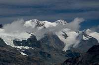
The main attraction naturally it the southern aspect of Matterhorn at the valley’s end. However the Monte Rosa Glaciers also attract attention as well as the backcountry summits on the Dent d’Herens Ridge. They are lesser known, lower in height but still very impressive with their many pinacles and towers. On Mont Pancherot’s summit you feel like you are hovering vertically above Lago di Cignana’s dam and Pacquier village 1300m underneath (both not true though).
The summits of Mont Pancherot appear to be popular with ibexes. We saw a huge herd of these mountain goats on the north summit (which we therefore didn’t visit) and smaller detachments closer to Finestra di Cignana. We joked that you always see ibexes where there are easily crowds of people and a perfect view. Just to make sure that they get photographed by us human tourists.
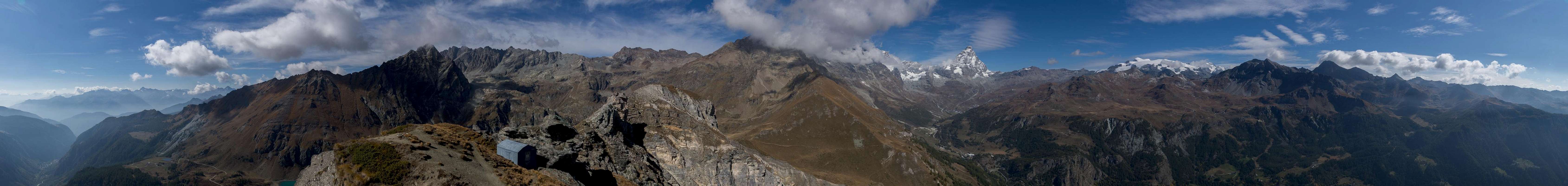
360° Summit Panorama
360° summit panorama from Mont Pancherot
Getting There
Ibex with Monte Rosa view
From Torino (Italy)
Take motorway A5 north
At Pavone Canavese motorway A4 joins
Stay on A5 until you reach the exit Saint Vincent / Chatillon
Switch to SR46 into Valtournenche
Just before you reach Paquier turn left onto a side road to Barmasse
From Lac Leman (Switzerland)
Take motorway A9 south to Martigny
Switch to B21 to Grand St. Bernard
>You can either drive through the tunnel (highway T5) or take B21 / SS27 across the pass to Aosta
Switch to SS26 or motorway A5 to Saint Vincent / Chatillon
Switch to SR46 into Valtournenche
Just before you reach Paquier turn left onto a side road to Barmasse
From Chamonix (France)
Take highway RN205 / T1 through Mont Blanc Tunnel
At Courmayeur it turns into motorway A5 taking you to Aosta and beyond
Stay on A5 until you reach the exit Saint Vincent / Chatillon
Switch to SR46 into Valtournenche
Just before you reach Paquier turn left onto a side road to Barmasse
From Val d’Isère (France)
Take highway RN90 to Petit St Bernard
Beyond the pass / frontier take SS26 to Pré St. Didier
Switch to motorway A5 to Aosta and beyond.
Stay on A5 until you reach the exit Saint Vincent / Chatillon
Switch to SR46 into Valtournenche
Just before you reach Paquier turn left onto a side road to Barmasse
Routes
In the Col between Mont Pancherot's summits
There are two hiking routes which both make use of the Balconata di Cervinio trekking trail.
Lago di Cignana Route
From Barmasse take a narrow hiking path which leads you in the direction of Lago di Cignana. You will pass an abandoned village and later cross a power station halfway up from the valley to the reservoir dam. The path then heads for the dam directly, only to climb the slopes to its northern side. If you want to stay at Rifugio Barmasse you have to cross the dam to the southern side of the lake.
The route then passes along the northern shore of the lake to its very end were a dirt road takes you in wide switchbacks towards two farmsteads. After the upper one the road turns into a path which quickly climbs to Finestra di Cignana. From here turn right onto the north-east ridge of Mont Pancherot. The path passes by the north summit, steadily gaining elevation. It then traverses a steep and narrow part of the ridge only to head up steeply to the south summit.
Lago di Perreres Route
From Barmasse or Paquier follow a maintenance road for the Perreres Reservoir, which heads along the western slopes of Valtournenche through some three or four tunnels. Reaching the reservoir turn left and back, climbing the west slopes of Valtournenche. It heads towards the south-west until it reaches the abandoned village Tza Grillon. Here a first switchback takes you north but after 500m another one turns you back towards the south-west and towards Finestra di Cignana. The remainder of the climb as described above.
Red Tape
Common European viper (also common adder, Vipera berus)
I’m not aware of any red tape in this area of Valtournenche. The slopes around Mont Pancherot are heavily used for grazing cattle. In the summer season close all gates and fences. In case you come across ibexes: you may watch but not disturb them as they are a protected species all over the Alps. The same holds true for other animals like the occasional viper you might encounter.
When to Climb
The best season is July through October. You can climb Mont Pancherot in winter but have to take care of avalanche conditions.
Accommodation
Valtournenche has a lot of hotels and apartments on offer. It is a very touristic area, especially in the valley end at Breuil-Cervinia (only recommendable for skiers in winter. A good starting point for accommodation search is this site:
Parents refers to a larger category under which an object falls. For example, theAconcagua mountain page has the 'Aconcagua Group' and the 'Seven Summits' asparents and is a parent itself to many routes, photos, and Trip Reports.

 3692 Hits
 81.18% Score
 13 Votes
 Mont Pancherot seen from Lago Cignana's dam


 Ibex with Monte Rosa view
 In the Col between Mont Pancherot's summits


 Common European viper (also common adder, Vipera berus)