
-
 12102 Hits
-
 81.18% Score
-
 13 Votes
|
|
Mountain/Rock |
|---|---|
|
|
28.96272°N / 13.70613°W |
|
|
Hiking |
|
|
Spring, Summer, Fall, Winter |
|
|
1978 ft / 603 m |
|
|
Overview
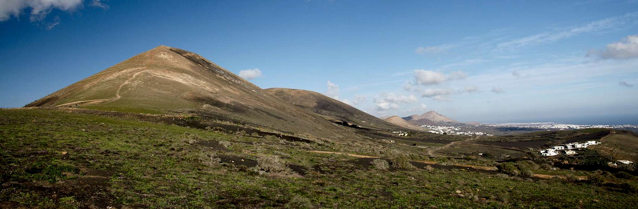
 Montaña de Guardilama as seen from Femes Montaña de Guardilama as seen from Femes |
Among the volcanoes of Lanzarote Montaña de Guardilama takes a special place in more than one way. It is one of the highest volcanoes on the island, though at 603m its height is far from impressive. Thanks to the height and thanks to ist location close to the island centre it has been dubbed "the best lookout peak of Lanzarote" and ona fine day it certainly rises to this level. The views are dominated by the Montañas del Fuego in the north-west, Lanzarote's fire mountains which erupted during a six year period between 1730 and 1736. The view of wild craters and extended lava flows stretches for almost 180° from the summit, while the rest is take by the tourist towns along the east coast, the Los Ajaches Range in the south and the neighbouring island of Fuerteventura beyond.
 |  |  |
Montaña de Guardilama is older than the Montañas del Fuego by several Millenia. During the island's second eruptive phase, which occured between 3000 and 5000 years ago, the centre of Lanzarote was formed. Volcanoes erupted along two major fault lines. Montaña de Guardilama is located at the southern end of the longer of the volcanic chains, the one named after the regional capital San Bartolomé. The mountain and its surroundings was saaved from the 1730 lava flows by a barrier of two older volcanoes to its north-west, Montaña Chupaderos (433m) and Montaña Diama (458m). However, like much of this part of the island, the whole area was covered by volcanic ashes out of which only the mountaintops stand out as pale remainders of the old country.
 Wine Growing Lanzarote Style
The volcanic ashes have established something in the valley between the three aforementioned mountains, which is unique to Lanzarote: dry-land farming. The island's climate is arid or desert like. The fat trade wind clouds sweep across it without leaving anything but dew for most of the year. Thus farmers need to save any drop of humidity n which task they are greatly helped by volcanic cinder, the so-called lapilli. The lapilli seep up any tiny bit of humidity and jealously keep it. Dig a half foot hole anywhere and any time - the ashes will be moist. Thus farmers dig deep holes in which they plant wine, figs or almonds. They cover the roots with one or two feet of lapilli, then protect the plants against the wind with a wall. This way the whole area around Montaña de Guardilama is a chequerboard of small pits, stretching towards the badlands of the 1730 lava flows. The area has been protected by the Paisaje Protegido de la Geria in which hiking and farming is allowed - but restricted along the trails and roads.
 Chequerboard vineyards
Like all volcanoes Montaña de Guardilama posesses a crater. It is typical for volcanoes on the Canary Islands. The trade winds have blown the ashes towards the south-west side of the volcano, where the crater rim is much higher than in the north-east. On Montaña de Guardilama the erosion which has taken place in long time interval which has passed since the eruption has eaten away much of the crater so that nowadays it can only be seen from above (see interactive map).
360° Summit Panorama
  |
Getting There
 |
Though there are ferries from the Spanish mainland to the Canary Islands, they take more than 24h for the trip. Therefore most visitors therefore go by plane. Every travel agency in Europe offers flights, hotel rooms, apartments, rental cars etc. so that reaching the Canaries is rather a matter of money than opportunity. During the summer season flight fares can be reasonable but during the Easter and Christmas holidays you have to be prepared for additional fees of 500€ per person.
Lanzarote has its own airport between the capital Arrecife and one of the main tourist centres, Puerto del Carmen. There are public bus lines but – like on all the islands – they don't run too regularly. If you plan to stay on your own, better take a rental car right at the airport.
The best trailhead for Montaña de Guardilama is the village of Uga in the south-west of the mountain. The best itinerary (not the shortest but most impressive one) is as follows (the shortest one is to follow LZ2 to Yaiza, which passes Uga):
- From Arrecife follow LZ20 through San Bartolomé.
- At the Monumento del Campesino turn onto LZ30 west.
- Drive through Masdache and ignore all intersections until you reach a roundabout.
- Take the first exit and drive into Uga.
Red Tape
 Montaña de Guardilama
Montaña de Guardilama is located inside the Paisaje Protegido de la Geria which has been established to protect the unique vineyards of the area. As stated in the overview section, the mountain is located in the heart of this area and at all times of the year you can depend on farming activities going on at its lower slopes. You may hike the roads and paths but are asked not to leave them.
Accommodation
For holiday homes, hotels or apartments either consult your nearest travel office, or – search for lodgings on Google. There are several sites on the web, dedicated to rent privately owned houses or apartments. Prices are generally a bit less expensive than for tour operators but you don't have as much security.Weather Conditions
As stated in the overview section, Lanzarote, is usually swept by fierce north-western trade winds. Though they deposit their humidity on almost all of the other Canary Islands, Lanzarote is simply too low to form a decent obstacle. Therefore the climate is very arid.For some time of the year, eastern winds prevail, which almost always carry clouds of Sahara dust with them. Usually this means reduced visibility but in some occasions "Calima" occurs. Fierce storms take up the dust from the Sahara and sweep it across the islands. In these times visibility is nil and sometimes even the planes are grounded.
Maps & Books
Maps
Regular Maps
- Lanzarote
Kompass Map WK241
Kompass Verlag
1:50000
ISBN 3-85491-175-0
Digital Maps
Kompass is the only company known to me which offers GPS digital Maps. In addition for those of you with Garmin GPS receivers there is a map source map set of all Canary islands out there.
- Lanzarote
Kompass GPS4241
Kompass Verlag
ISBN 3-85491-223-4
- Islas Canarias
Map Source custom map
By Manfred Pepper
downloadable zip-file
Books
My recommendation is a guidebook by Rother Verlag, available in German. The book is an excellent hiking guide covering all the interesting areas of the island. Since it comes with small maps for each excursion it might even be used without a map to support them.
- Lanzarote
Rolf Goetz
Rother Verlag
ISBN 3-7633-4302-4