
-
 1517 Hits
-
 79.78% Score
-
 11 Votes
|
|
Mountain/Rock |
|---|---|
|
|
27.94109°N / 15.68275°W |
|
|
Download GPX » View Route on Map |
|
|
4770 ft / 1454 m |
|
|
Overview
 Montaña de Solapos de Carniceria and Morro de la Negra Montaña de Solapos de Carniceria and Morro de la Negra |
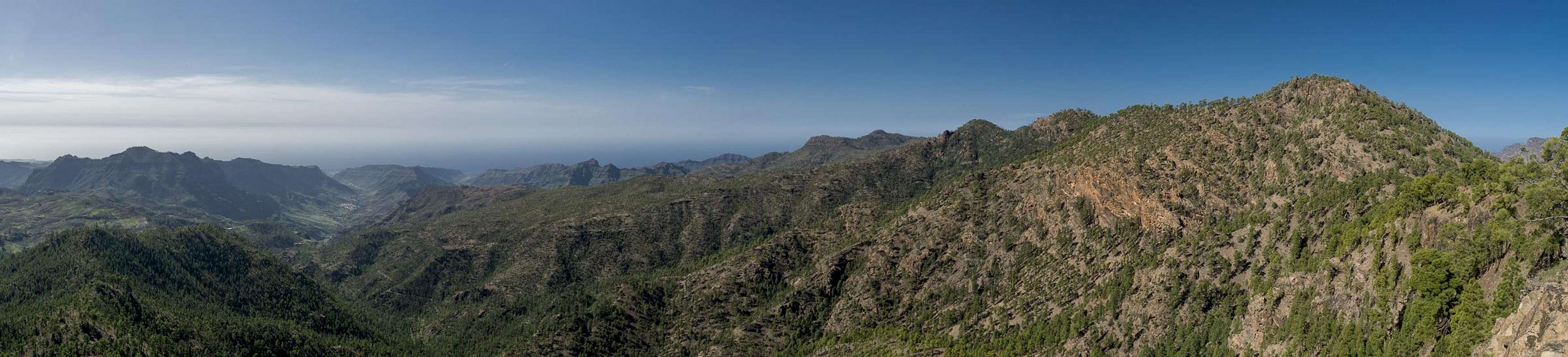
Caldera de Tejeda, the huge erosion crater in the east of Gran Canaria is bounded by two long curved ridges, which start from the Cumbre Central and lead to the west coast near San Nicholas de la Aldea. Both ridges offer wonderfully panoramic hikes, the northern one culminating in Los Moriscos near Artenara, while the southern one, the Pajonales Ridge, has its highpoint in Montaña de Sandara. The ridge starts at Degollada del Asserador, winding towards Montaña del Viso, high above Barranco de San Nicholas, the canyon which drains the caldera.
 |  |  |
Montaña de Solapos de Carniceria is located a little to the south of the ridge, close to Morro de la Negra and Montaña de Sandara. Its summit is covered in Canary Pines but two platforms, which head out from the mountain to the south-west and south-east offer nice views across the high plain in the centre of the island. It is part of the Reserva Natural de Pajonales, a natural park, set aside to protect the very dry and brittle area. Infrequently, but rather regularly forest fires rage in the west and south-west of the island, burning the undergrowth but leaving the pines with their thick bark intact. The last of these fires raged in the summer of 2007 and the Pajonales Park is still struggling hard to recover. There is not much undergroowth yet and the pines only sprout thick clusters of their soft and long needles directly from their blackened trunks.
 |  |  |
Like everything on Gran Canaria Montaña de Solapos de Carniceria is of volcanic origin. It has a basalt core which comes to light in the two aforementioned platforms. However, most of the mountain is covered in volcanic ashes which over the centuries since the last eruption have turned into a very soft mineral rich soil. But for the dry, desert like weather, plants would florish. As it is, only rock roses and the hardy Canary Pines survive.
Panoramic View
  |
Getting There
 Montaña de Solapos de Carniceria with the eastern Pajonales Crest
Gran Canaria can be reached from any major European airport. Usually charter carriers fly there but the spanish airline Iberia has also regular flights. The airport is on the eastern coast of the island, far away from the tourist centres in the south.
Trailheads for Montaña de Sandara are at Degollada del Asserador, El Juncal and at Presa de las Cuevas de las Niñas.
- From the south
- From Maspalomas take GC60 through Fataga and San Bartolome to the saddle Cruz Grande.
- From the saddle stay on GC60 until you get to Ayacata.
- For Embalse de las Cuevas de las Niñas turn left onto GC605 which passes the reservoir.
- For Degollada del Asserador and El Juncal stay on GC60. The road to El Juncal turns off left about 500m after the degollada.
- From the north
- From Telde take GC131 which turns into GC130, direction Pico de la Nieve. The road will hit GC150 right at Gran Canaria's highpoint.
- Stay on GC150 for a few metres, then turn onto GC600 to Ayacata.
- For Embalse de las Cuevas de las Niñas turn left onto GC605 which passes the reservoir.
- For Degollada del Asserador and El Juncal stay on GC60. The road to El Juncal turns off left about 500m after the degollada.
Routes Overview
 Roque Nublo and Pico de las Nieves above the Pajonales Crest
- Pajonales Ridge Traverse from Degollada del Asserador: a wonderful hike along the Pajonales Ridge with exceptional views to the Cumbre Central. Montaña de Solapos de Carniceria lies beyond the saddle Cruz de la Huesita so a round trip is a very long affair. Still this is the most panoramic of routes.
- Hike from El Juncal: A forest road leads from El Juncal to Embalse de las Cuevas de las Niñas. Park either in the village or some 2km along the road at a forest cabin. Hike the road to the saddle Cruz de la Huesita, where you turn west onto the Pajonales Ridge. The route is a combination of hikes along a dirt road and along paths. Once you reach the saddle between Morro de la Negra and Montaña de Solapos de Carniceria turn left sharply and follow the broad backed risge to the summit.
- Road Hike or Dirt Scrabmle to Cruz de la Huesita: From Embalse de las Cuevas de las Niñas either follow the dirt road to Cruz de la Huesita or - starting at the camping zone - hike along a steep path through the pine forest. Both routes lead to the saddle from where you turn west onto the Pajonales Ridge
Red Tape
The Pajonales ridge is part of Reserva Natural de Pajonales. Hiking and climbing are allowed, camping isn't. Take care with fire! In 2007 a huge forest fire raged the park and the whole south-west of the island, killing everything but the hardy Canary Pines.Accommodation
Gran Canaria has a lot of options for accommodation. Most visitors book hotel rooms from their travel offices or over the internet. However, you will most certainly end up in the ugly tourist centres along the south coast. Therefore a much better solution is to rent a holiday home, most often a rural finca. This can also be done by travel office or internet.Camping is a bit of an issue on all the Canary Island. There are designated camping zones but getting a place often involves some bureaucracy. The closest campground is at Embalse de las Cuevas de las Niñas some 2km to the south of the mountain. Wild camping is not permitted anywhere on the island.
Weather Conditions
 Caldera de Tejeda with Morro de la Negra to the right
The following table gives a rough general overview over the weather on Gran Canaria, at sea level.
| Month | Jan | Feb | Mar | Apr | May | Jun | Jul | Aug | Sep | Oct | Nov | Dec |
| Avg. day temp.[°C / °F] | 21 / 70 | 21 / 70 | 22 / 72 | 22 / 72 | 22 / 72 | 23 / 73 | 24 / 75 | 25 / 77 | 25 / 77 | 25 / 77 | 24 / 75 | 22 / 72 |
| Avg. night temp.[°C / °F] | 16 / 61 | 16 / 61 | 16 / 61 | 17 / 63 | 16 / 61 | 17 / 63 | 18 / 64 | 20 / 68 | 20 / 68 | 18 / 64 | 18 / 64 | 17 / 63 |
| Water temp.[°C / °F] | 19 / 66 | 18 / 64 | 19 / 66 | 19 / 66 | 19 / 66 | 20 / 68 | 22 / 72 | 23 / 73 | 23 / 73 | 23 / 73 | 21 / 70 | 20 / 68 |
| Rainy days | 4 | 3 | 2 | 2 | 1 | 1 | 1 | 1 | 1 | 3 | 3 | 3 |
The Canary Islands (as well as Madeira) are located in the trade wind zone. You almost always encounter northeastern winds which carry a lot of humid air. Being forced to climb to higher altitudes this moisture condenses into clouds. This in return means that most of the time the northeastern part of the islands is covered in clouds from altitudes of 1000m through 1500m.
The mountainous region in the centre of the island is of the same alltitude and higher and thus stops the clouds. While the northern parts of the islands can be foggy and rainy the southern parts most often are sunny and hot. On Gran Canaria the north-eastern part of the island collects almost all moisture. However, unlike on the other Canary Islands no cloud forest remains. The laurisilva fell victim to the agricultural development of the island.
Maps & Books
Regular Maps
- Gran Canaria
Kompass Map WK237
Kompass Verlag
1:50000
ISBN 3-85491-114-9
- Gran Canaria North
Public Press Map 442
1:50000
ISBN: 978-3-89920-442-1
- Gran Canaria South
Public Press Map 443
1:50000
ISBN: 978-3-89920-443-8
Digital Maps
Kompass is the only company known to me which offers GPS digital Maps. In addition for those of you with Garmin GPS receivers there is a map source map set of all Canary islands out there.
- Gran Canaria
Kompass GPS4237
Kompass Verlag
ISBN 978-3-85491-219-4
- Islas Canarias
Garmin Map (many islands including Gran Canaria)
downloadable files
Books
My recommendation is a guidebook by Rother Verlag, available in English and German. The book is an excellent hiking guide covering all the interesting areas of the island. Since it comes with small maps for each excursion it might even be used without a map to support them.
- Gran Canaria
Izabella Gawin
Rother Verlag
ISBN 978-3-7633-4816-9 (English)
ISBN 978-3-7633-4000-2 (German)