
-
 4795 Hits
-
 75.81% Score
-
 6 Votes
|
|
Mountain/Rock |
|---|---|
|
|
27.88739°N / 15.60092°W |
|
|
Hiking, Scrambling |
|
|
Spring, Summer, Fall, Winter |
|
|
3520 ft / 1073 m |
|
|
Overview
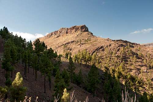 Montaña Negra seen from the north-east Montaña Negra seen from the north-east |
Pilancones Natural Park is one of the driest places of the dry south of Gran Canaria. The usual trade wind clouds, which hit the island from the north-east, usually get blocked by the Cumbre Central, the almost 200m high plateau in the centre of Gran Canaria and even if they dont't they spill over only slightly into the park. What little water there is is collected in reservoirs, which serve as source of drinking water for the tourist villages on the coast.
At more or less regular intervals the park gets devastated by big fires, which feed on the fallen needles of Canary Pines but which rarely hurt the trees themselves, thanks to their thick bark. However, over time most of the pines have fallen victim to the fires and nwoadays the park looks reddish brown wherever you look. In its centre, there is a standalone signature mountain, visible from anywhere inside the park: Montaña Negra.
 |  |  |
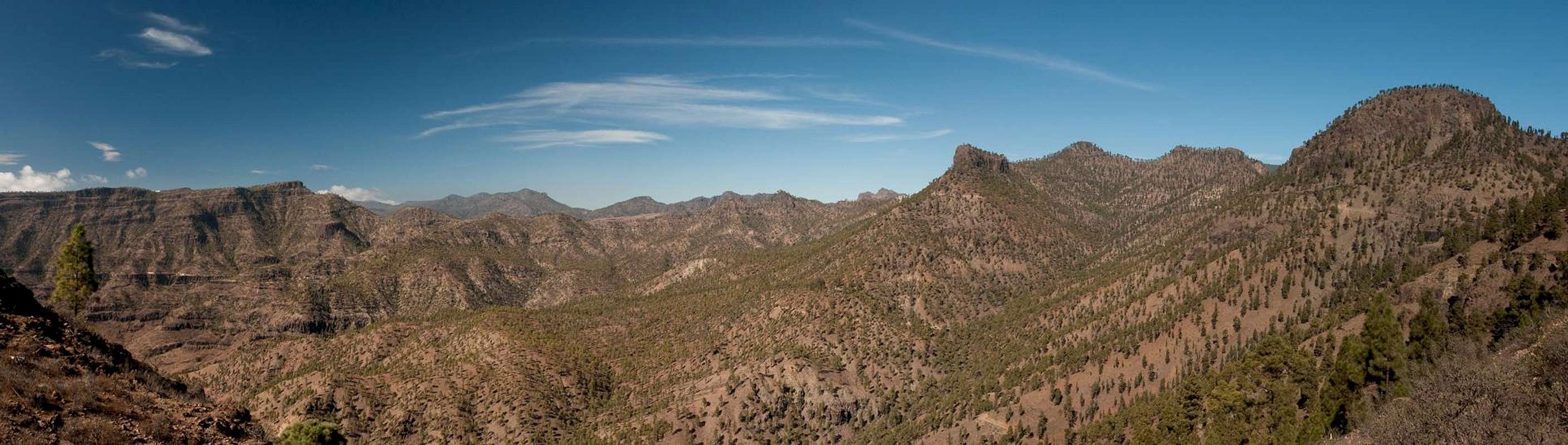
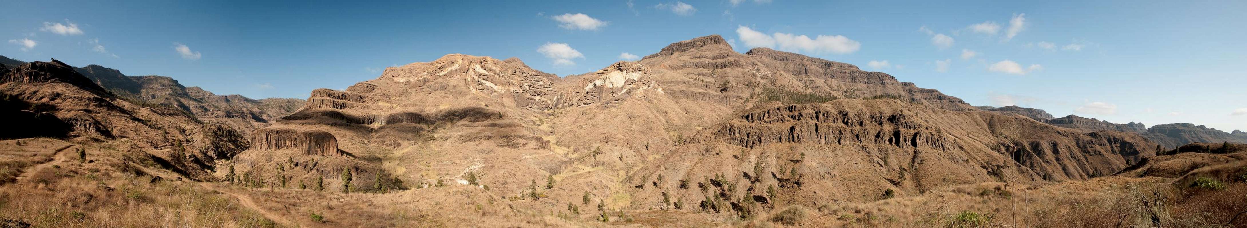
Montaña Negra, the black mountain, is darker than its neighbours. It is made up from black basalt with a cricle of pillars surrounding its top. The summit itself is a wide plateau, which braks off across these pillars which reach a length of up to 50m. Only the east side is open, where you can reach the summit from an unnamed saddle, scrambling steep, rocky slopes.
 |  |  |
Montaña Negra is a big bulk of a mountain. Though it only reaches 1076m and though its summit plateau is rather small, its foundation is very wide. There are several summits, all of which much lower than the central one and reaching only between 700 uan 800m.To the west the south face of Montaña Negra houses a multitude of caves. Here the rock is far less solid and over the ages the little rain which falls in this area has washed out these caves.
Getting There
  |
Gran Canaria can be reached from any major European airport. Usually charter carriers fly there but the spanish airline Iberia has also regular flights. The airport is on the eastern coast of the island, far away from the tourist centres in the south.
Most reasonable trailhead for Montaña Blanca is Ayagaures, a village in the south. Much longer and complicated is the hike from Cruz Grande
- Ayagaures
- Take motorway GC1 to Maspalomas.
- From the exit Maspalomas / Fataga take GC500 / Avenida Alejandro del Castilo through residential areas to the west.
- From the roundabout at the end take GC504 Ayagaures.
- Cruz Grande
- Take motorway GC1 to Maspalomas.
- From the exit Maspalomas / Fataga take GC60 through Fataga and San Bartolome de Tirajana to the road crossing Cruz Grande
Routes
 The reservoirs at Ayagaures, trailhead for Montaña Blanca
The Ayagaures route follows the dirt road on the left (west) side of the first reservoir, then switches to the left (east) side of the second one. It runs through the hamlet Casas de Ayagaures, then straight ahead all the way to the unnamed saddle to the east of Montaña Negra. From here a pathless scramble takes you to the top of the mountain.
 |  |  |
From Cruz Grande follow the signs for Degollada de la Manzanilla. It runs around Morro Guanil, an impressive basalt tower. From the saddle take the western trail which descends steeply into Pilancones Park. At the next intersection take the right hand (southern) road which leads to the unnamed saddle east of Montaña Negra. From here a pathless scramble takes you to the top of the mountain.
Red Tape
 |
Pilancones is a natural park. The usual restictions apply. Be extremely careful with fire. The black bark of the Canary Pines will tell you why.
Accommodation
Gran Canaria has a lot of options for accommodation. Most visitors book hotel rooms from their travel offices or over the internet. However, you will most certainly end up in the ugly tourist centres along the south coast. Therefore a much better solution is to rent a holiday home, most often a rural finca. This can also be done by travel office or internet.Camping is a bit of an issue on all the Canary Island. There are designated camping zones but getting a place often involves some bureaucracy. The closest campground is at Embalse de las Cuevas de las Niñas some 4km to the east of Cruz Grande. Quite a long way from Montaña Blanca, actually.
Weather Conditions
The following table gives a rough general overview over the weather on Gran Canaria, at sea level.| Month | Jan | Feb | Mar | Apr | May | Jun | Jul | Aug | Sep | Oct | Nov | Dec |
| Avg. day temp.[°C / °F] | 21 / 70 | 21 / 70 | 22 / 72 | 22 / 72 | 22 / 72 | 23 / 73 | 24 / 75 | 25 / 77 | 25 / 77 | 25 / 77 | 24 / 75 | 22 / 72 |
| Avg. night temp.[°C / °F] | 16 / 61 | 16 / 61 | 16 / 61 | 17 / 63 | 16 / 61 | 17 / 63 | 18 / 64 | 20 / 68 | 20 / 68 | 18 / 64 | 18 / 64 | 17 / 63 |
| Water temp.[°C / °F] | 19 / 66 | 18 / 64 | 19 / 66 | 19 / 66 | 19 / 66 | 20 / 68 | 22 / 72 | 23 / 73 | 23 / 73 | 23 / 73 | 21 / 70 | 20 / 68 |
| Rainy days | 4 | 3 | 2 | 2 | 1 | 1 | 1 | 1 | 1 | 3 | 3 | 3 |
The Canary Islands (as well as Madeira) are located in the trade wind zone. You almost always encounter northeastern winds which carry a lot of humid air. Being forced to climb to higher altitudes this moisture condenses into clouds. This in return means that most of the time the northeastern part of the islands is covered in clouds from altitudes of 1000m through 1500m.
The mountainous region in the centre of the island is of the same alltitude and higher and thus stops the clouds. While the northern parts of the islands can be foggy and rainy the southern parts most often are sunny and hot. On Gran Canaria the north-eastern part of the island collects almost all moisture. However, unlike on the other Canary Islands no cloud forest remains. The laurisilva fell victim to the agricultural development of the island.
Maps & Books
Regular Maps
- Gran Canaria
Kompass Map WK237
Kompass Verlag
1:50000
ISBN 3-85491-114-9
- Gran Canaria North
Public Press Map 442
1:50000
ISBN: 978-3-89920-442-1
- Gran Canaria South
Public Press Map 443
1:50000
ISBN: 978-3-89920-443-8
Digital Maps
Kompass is the only company known to me which offers GPS digital Maps. In addition for those of you with Garmin GPS receivers there is a map source map set of all Canary islands out there.
- Gran Canaria
Kompass GPS4237
Kompass Verlag
ISBN 978-3-85491-219-4
- Inselkartes
OSM Topo Map of European Islands
Garmin Maps
Books
My recommendation is a guidebook by Rother Verlag, available in English and German. The book is an excellent hiking guide covering all the interesting areas of the island. Since it comes with small maps for each excursion it might even be used without a map to support them.
- Gran Canaria
Izabella Gawin
Rother Verlag
ISBN 978-3-7633-4816-9 (English)
ISBN 978-3-7633-4000-2 (German)