-
 2878 Hits
-
 79.78% Score
-
 11 Votes
|
|
Mountain/Rock |
|---|---|
|
|
45.84969°N / 10.05642°E |
|
|
Download GPX » View Route on Map |
|
|
Hiking, Skiing |
|
|
Spring, Summer, Fall, Winter |
|
|
4787 ft / 1459 m |
|
|
Overview
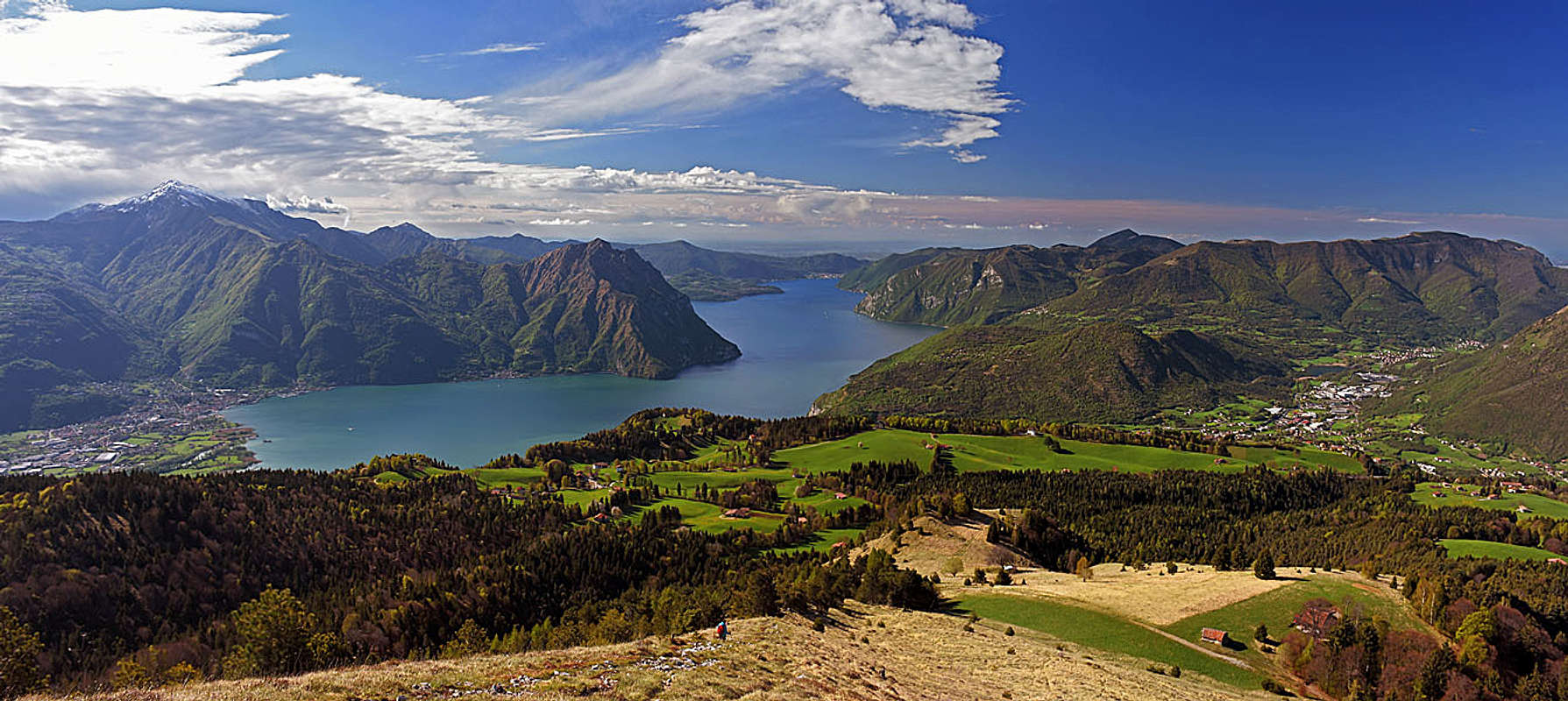
This is another mountain above the Lake Iseo with wonderful panorama. The view southwards is absolutely harmonic, not only due to the lake and mountains around, but also due to the wonderful grassy plateau of Bossico in front. The grassy slopes of Monte Colombina are falling gently down some 300 m, where the big balcony is stretching, covered with nice woods and meadows. On its edge, just above the town of Lovere, I guess there are some of the most valuable places where villas and beautiful houses of locals are standing. The lake is still some 700 m below.
So, again, this is not a summit for mountaineering, not even for more serious hiking challenges. But if you ascend it on a beautiful morning or evening, you will always remember that half day outing.
Regarding the name - on some maps it's written as Monte Colombina, on others Monte Valtero.
A bit of geography


Down on the shores of Iseo Lake, there's on 200 m of elevation Lovere, a vibrant town, living of tourism and some industry. Just above it, in the northwestern direction, steep, partly rocky slopes are rising. The first elevation, built of triassic dolomite, is Monte Cala, 615 m. There up was a sanctuary already in antiquity, today's church is dedicated to San Giovanni and is a popular pilgrimage place. From Lovere it can be reached in some 1 h 15 min by various trails.
One stage higher, on some 840 m, the plateau of Bossico starts. The touristically well developed village is in the SW part of its big triangle, the rest are wonderful meadows and gently inclined slopes, looking down on the lake. On the eastern side, the plateau is bordered by a long valley, named Val di Supine, above which also our mountain is rising. It ends with the place named Fontana Fredda. The summit of Monte Colombina is actually a grassy ridge, running in the S-N direction. On the panoramic southernmost point there's a big cross. But I guess a bit higher is the northernmost elevation, which is however overgrown and without big views around. West of the mountain is the highest hamlet and a small chapel of St. Fermo, 1250 m.
Panorama
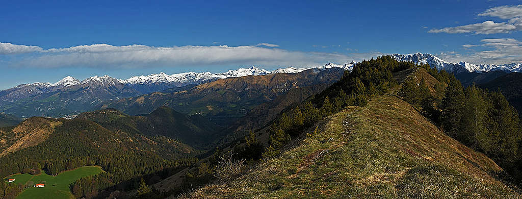
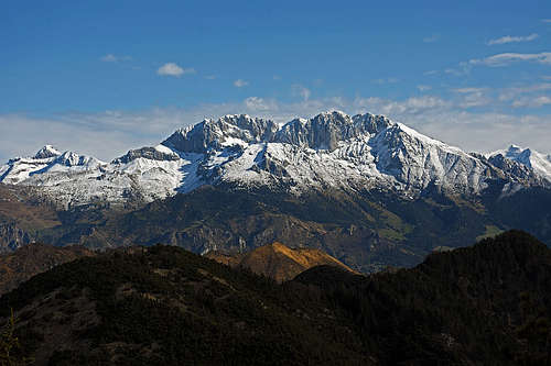
The great view southwards, on Lake Iseo, was already mentioned. But nice is also the W and NW panorama, where many of high summits of Alpi Orobie can be seen. The parade mountain is Presolana, which is not so far northwards. But to see it in whole splendor, we must go on the northern summit and find there a place with open view northwards. Towards the east, across the low Val Camonica, many summits of Brescia Prealps can be seen.
Getting There


Monte Colombina can be reached from all sides, but short and popular approaches are coming from the side of Bossico. The village is reached by a good asphalted road from the SW, from Sovere. The other, also nice, but less used possibility, is to drive from the shores of Iseo Lake up through the five villages above Costa Volpino. I guess in the highest one, in Ceratello, 800 m, we must park, even if a narrow road goes from there also up on the plateau of Bossico.
In Bossico we can park already by the church, 870 m, or we can drive by the Via San Fermo road a few hundred meters more northwards, to the Pila parking. This is the itinerary via Chiesetta dei Cadutti. The other option is to drive from the church by the main road eastwards and then northwards up all the way to the highest agritourism, called Five Firs (Cinque Abeti), 1010 m.
The Hikes
Show a bigger map
All the hikes are easy, even the summit slopes are not too steep and on the Swiss Hiking Scale the ascent difficulty hardly reaches the T2 level.

1. From Five Firs, via Forcellino di Bossico. From the agritourism we go by the cart-road just some 100 m left (W-NW), then we deter right and follow the marked path northward. It goes through the woods and reaches the Bossico saddle, 1175 m, in some 20 min. There we keep left (straigt is the path to Fontana Fredda), slightly ascending over the slopes of Colombina. Over two clearings (on one is the plague refuguiom from the 17th century) we soon reach the nice saddle south of Monte Colombina. There turn right and ascend by the southern ridge (unmarked path) directly on top. That's the shortest way, some 1 h 20 min.
2. From Bossico, via Chiesetta dei Cadutti. From the church we go northwards, following the inscriptions for the memorial chapel. From the Pila parking we continue by the road through the woods to the memorial chapel and further on to San Fermo saddle. Till here, many come also by bikes. From San Fermo in the eastern direction by the good path on the 200 m higher summit. Some 2 h.
The terrain is more or less easy everywhere, so you must take care only of orientation. From the saddle just below the South ridge, we for example descended by nice meadows and a pathless terrain directly southwards, and then in the woods soon found the way eastwards to the Five Furs agritourism.
When To Ascend?
Monte Colombina can be ascended in any season. In any case, choose a clear day to enjoy the beautiful panorama. I don't know if in winter cross-country ski tracks are arranged, but also a usual winter ascent or a ski tour over the grassy slopes must be very nice.