Overview
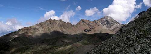
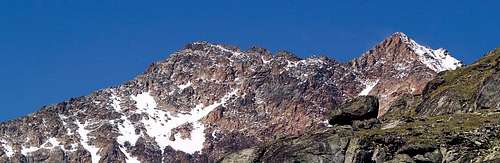
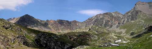
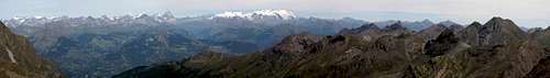
![From Emilius edge. NE ridge...]()
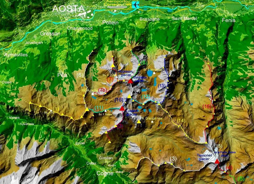
The Monte Emilius Group, located at the center of Valle d'Aosta, covers a vaguely trapezoidal area thus delimited:
- From the north by the main valley, between the Villages of Saint Marcel and Aymavilles. The Dora Baltea River runs through the valley.
- From the south and the west by Vallone dell'Urtier (vallone means hanging valley) and Valle di Cogne. The Grand Eyvia creek runs through the latter and, in Aymavilles, flows into Dora Baltea.
- From the east by Vallone di Clavalitè, which also forms the western boundary of the group known as "Mont Glacier, Mont Avic e Rosa dei Banchi".
- From the southeast, very briefly, by Vallone di Champorcher, in the stretch of the ridge between Col Pontonnet and Finestra di Champorcher.
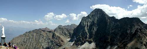
![]()
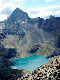
The group includes important summits like Punta Tersiva (3.515m) and Punta Garin (3.451m), but its center is Monte Emilius (3.559m), from which several ranges depart to form the watersheds of hanging valleys, studded with incomparably beautiful lakes and inhabited by chamois, ibex, fox, eagles, and marmots. (This fauna often comes from the nearby Parks of Gran Paradiso and Mont Avic) The hanging valleys that go approximately from north to south along the sides of the Central Valley, and originate directly from Monte Emilius, are (from east to west):
- Vallone di Laures (or Brissogne) under the East face of Monte Emilius.
- Vallone di Arpisson, at whose head is the North face of Emilius.
- Vallone di Comboè, which, after a cliff, suddenly changes direction (from north-south to east-west) and-going around the western spur that descends from the Emilius Summit to Petit Emilius and Mont Ross de Comboè-forms Comba di Arbolle (or Arbole).
- This hanging valley provides the access to the standard route to Monte Emilius, which attains the summit running along the Tre Cappuccini ridge from the namesake col, which takes its name from three characteristic gendarmes.
To the west of the aforementioned hanging valleys, the Monte Emilius Group includes the vast Conca di Pila (Pila Basin), a popular ski resort in winter, but less crowded in summer, while to the east, the last valley entirely belonging to the Emilius Group is Vallone di Saint Marcel, which also goes from north to south, and is connected by the namesake pass (also known as Colle Coronas) to Vallone di Grauson.
Valle di Cogne, which makes up the long western and southern boundary of the group, terminates with Vallone dell'Urtier, where the namesake creek forms the magnificent Lillaz Falls-a great attraction for tourists in summer and ice climbers in winter. On the sides of Valle di Cogne, two hanging valleys reach deep into the group, merging at Punta Garin; they are:
- Vallone di Arpisson (di Cogne) or Pian Bessey
- The long and vast Vallone di Grauson, mostly above 2.400m of elevation. Its branch, named Vallone di Lussert, extends northwards, that is towards the center of the group. At the eastern head of its main branch, more exactly named Vallone di Doreire, rises the unmistakeable outline of Tersiva.
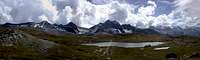
Moving the cursor one can see the overall scene
|
Monte Emilius Group from West |
Cities and Villages
Numerous cities and villages contour the group:
Valle di Cogne
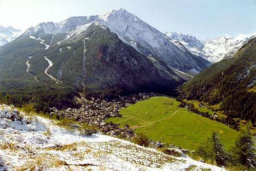
- Cogne (population 1.466), 1.534m and its surrounding villages: Epinel, Cretaz, Gimillan e Lillaz
Valle centrale
- Aymavilles (population 2.069), 646m and the hamlet of Ozein 1.363m
- Jovencan (population 759), 632m
- Gressan (population 3.374), 626m with the important winter sports resort of Pila 1.790m
- Charvensod (population 2.533), 746m
- AOSTA (population 35.010) the region's capital, 583m
- Pollein (population 1.578), 551m
- Brissogne (population 1.008), 827m
- Saint Marcel (population 1.297), 630m and the hamlet of Druges, 1.588m
(Population data are from 2013)
![View after a summer snowfall from Gimillian <br>of Prato di Sant Orso, Cogne and Valnontey]() Cogne and Prato di Sant'Orso Cogne and Prato di Sant'Orso
|
![Grand Combin]() Aosta Aosta
|
Getting There
BY CAR:
- From Torino, Milano, etc: Motorway A5. Exit at Aosta Ovest. Drive to the nearby Aymavilles. Follow the directions for Valle di Cogne.
- From Switzerland: through the Grand Saint Bernard Tunnel or the namesake pass. Drive to Aosta, then follow the direction for Courmayeur on SS.26. Just after Sarre, turn left, in the direction of Valle di Cogne.
- From France: through Mont Blanc Tunnel or Petit Saint Bernard Pass. It is not necessary to take Motorway A5: you can drive on SS.26, in the direction of Aosta. Before arriving at the Village of Sarre, turn right following the sign for Valle di Cogne. Starting from Cogne there are two possibilities: Follow the road signs for Gimillan and Lillaz; arrived at a roundabout, recently built in proximity of the St. Anthony Chapel, go left along the scenic route leading to the Village of Gimillan (1.787m), 3 Km. after Cogne. Usually no parking problem. From here you can get many spots of the Monte Emilius Group:the ridge between Valle di Cogne and Pila Basin, the Vallone di Pian Bessey, the ridge between Vallone di Pian Bessey and Vallone di Grauson, Vallone di Grauson-Lussert. Going right at the roundabout, after 3 Km. the road arrives at the Village of Lillaz (1.615m), famous for his wonderful waterfalls. From Lillaz starts an unpaved and rough road, appropriately closed to the cars (except 2-3 days in August, on the occasion of San Besso and Madonna delle Nevi festivities). It follows all the long Urtier Valley as far as the recently built Sogno di Berdzè Hut (2.526m), at the foot of Finestra di Champorcher (2.828m), a pass connecting the Urtier and Champorcher Valleys. From the head of Urtier Valley, through Passo d'Invergneux you get directly the head of Grauson Valley, just at the foot of Punta Tersiva.
If you want instead to get to Pila: starting from the City of Aosta, follow the sign for Pila: a long and winding road will lead you from Aosta
(583m) to Pila (about
1.800m). Pila is the starting point nearest to the Emilius Summit.
Cogne and Pila are reachable also by public transportation. In addition, there is a cableway connecting directly Aosta to Pila.
BY PLANE:
- Aeroporto "Corrado Gex" Saint Christophe (Aosta).
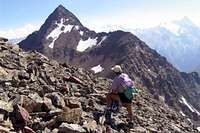
![Punta de la Pierre]()
Summits and Passes of the GROUP : Northern Sector
In the northern sector of the Emilius Group, consisting of the southern secondary valleys of the Central Valley:
![Vallone di Arbolle]() Vallone di Arbolle Vallone di Arbolle |
![The pleasant Vallone di Comboè, at the foot of Becca di Nona <i>3142m</i>]() Vallone di Comboé Vallone di Comboé |
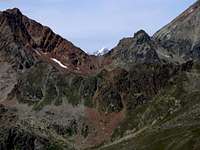
![Vallone di Arpisson dominated from the northern wall of Monte Emilius <i>(3559m)</i>]() Vallone di Arpisson Vallone di Arpisson |
![N. side of monte Emilius <i>(3559m)</i> and vallone di Arpisson, seen descending from alpe Viou]() Vallone di Arpisson Vallone di Arpisson |
![The hanging valley (vallone) of Laures]() Vallone di Laures or Brissogne Vallone di Laures or Brissogne |
![Vallone di Laures]() Vallone di Laures or Brissogne Vallone di Laures or Brissogne |
- Vallone di Laures or Brissogne
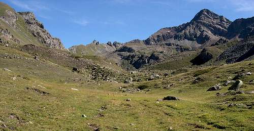
![Vallone di Saint Marcel and its eastern ridge separating it from Vallone di Clavalitè]() Vallone di Saint Marcel Vallone di Saint Marcel |
6) Ridge between Conca di Pila
and Comba di Arbolle-Vallone di Comboè
- Punta della Valletta (3.090m)
- Mont Belleface or Bellafaca (2.970m)
- Testa Nera or Aouille Nera (2.819m)
- Colle di Chamolè (2.641m)
- Punta Replan (2.459m)
- Colle Replan (S. 2.440m and N. 2.400m)
- Signal Sismonda (2.347m)
- Colle Plan Fenêtre (2.221m)
- Punta di Ponteilles (2.262m)
- Punta Valletta (2.164m)
- Punta del Dard or Becca de Rien or Becca de Ren (2.033m)
7) Ridge between Vallone di Comboè-Comba di Arbolle and Vallone di Arpisson
- Dente della Becca di Nona (2.736m)
- Becca di Nona (3.142m)
- Colle Carrel (2.900m)
- Dente del Mont Ross (3.150m)
- Mont Ross de Comboè (3.285m)
- Piccolo Emilius (3.342m)
- Monte Emilius (3.559m)
7b) Ridge between Vallone di Comboè and Comba di Arbolle
![Monte Emilius and the ridge between Vallone di Comboè and Comba di Arbolle]() Monte Emilius and the ridge between Vallone di Comboè and Comba di Arbolle Monte Emilius and the ridge between Vallone di Comboè and Comba di Arbolle |
- Mont Ross de Comboè (3.285m)
- Col Ross (3.078m N, 3.091m S)
- Punte del Lago Gelato (3.113m)
- Colle di Comboè (2.990m)
- Trident de Comboè (N. 3.083m, Centrale 3.070m, and SW 3.057m)
8) Ridge between Vallone di Arpisson and Vallone di Laures
![View from the summit of Becca di Nona <i>3142m</i>]() In the foreground the ridge between Vallone di Arpisson and Vallone di Laures In the foreground the ridge between Vallone di Arpisson and Vallone di Laures |
- Monte Emilius (3.559m)
- Triangolo Nero dell'Emilius (3.378m)
- Colle Blantsette (3.137m)
- Tête Blantsette (3.140m)
- Colle Peccoz or Peckoz (3.042m)
- Becca di Senèva (3.086m)
- Torrioni di Senèva (N. 2.985m, S. 3.000m)
- Le Cordagnë (2.927m)
- Punte di Senèva (N. 2.645m, Centrale 2.640m, and S. 2.652m)
- Mont Père Laurent (2.625m)
9) Ridge between Comba di Arbolle and Vallone di Laures
- Monte Emilius (3.559m)
- I Tre Cappuccini (3.243/3.227/3.239m)
- Passo dei Tre Cappuccini (3.222m)
- Punta dei Tre Cappuccini (3.283m)
- Colle di Arbolle (3.154m)
- Punta Rossa dell'Emilius: Punta E. (3.400m)
10) Ridge between Comba di Arbolle and Vallone di Grauson
- Punta Rossa dell'Emilius (Punta E 3.400m): Punta Centrale (3.395m) and Punta W. (3.401m)
- Col Valaisan or Pas du Valaisan (3.196m)
- Mont Valaisan (3.296m)
11) Ridge between Comba di Arbolle and Vallone di Arpisson (Cogne)
![The ridge between Vallone di Arpisson <br>(di Cogne) and Vallone di Arbolle]() The ridge between Vallone di Arpisson (Cogne) and Vallone di Arbolle The ridge between Vallone di Arpisson (Cogne) and Vallone di Arbolle |
- Mont Valaisan (3.296m)
- Campanile d'Arbolle (3.096m)
- Guglie d'Arbolle (2.972m)
- Colle Garin (2.815m)
- Punta di Pian Bessey (3.081m)
- Colle della Valletta (3.000m)
- Punta della Valletta (3.090m)
12) Ridge between Vallone di Laures and Vallone di Grauson-Lussert
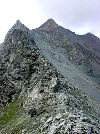
![The ridge between Colle di Laures <i>3036m</i> (left) and Punta di Leppe <i>3305m</i> (right)]() The ridge between Vallone di Laures and Vallone di Grauson-Lussert The ridge between Vallone di Laures and Vallone di Grauson-Lussert |
- Punta Rossa dell'Emilius, East (3.400m)
- Punta di Laures (3.367m)
- Colle di Laures (3.036m)
- Mont des Laures (3.120m)
- Colle di Lussert (3.115m)
- Punta di Lussert (3.221m)
- Punta di Leppe (three summits) (3.305m)
13) Ridge between Vallone di Laures and Vallone di Saint Marcel
- Punta di Leppe (three summits) (3.305m)
- Colle di Leppe (3.108m)
- Punta Ilario Antonio Garzotto (3.274m)
- Grande Roèse (3.357m)
-
- Punte Gianni Junod or Roèse Centrale (3.300m S, 3.296m N)
-
- Petite Roèse (3.279m)
- Punta di Praborna (3.128m)
- Punta di Vauvire (2.852m)
- Colle di Salè (3.025m)
- Becca di Salè (3.137m)
- Tour de Salè (3.072m)
- Punta di Bonplan (2.664m)
- Testa di Selva Plana (2.349m)
14) Ridge between Vallone di Grauson-Doreire and Vallone di Saint Marcel
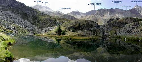
![From the shore of Layet lake]() The ridge between Vallone di Grauson-Doreire and Vallone di Saint Marcel The ridge between Vallone di Grauson-Doreire and Vallone di Saint Marcel |
- Punta di Leppe (3.305m)
- Colle del Vallonet (3.062m)
- Monte Vallonet (3.098m)
- Colle di Saint Marcel (2.916m)
- Punta di Laval (N-W 3.091m, S-E 3.102m)
- Punta Gianni Vert (3.148m)
- Colletto del Tessonet (3.066m)
- Punta del Tessonet (3.264m)
15) Ridge between Vallone di Grauson-Doreire and Vallone di Clavalitè
- Punta del Tessonet (3.264m)
- Costa del Tessonet (3.313m)
- Colletto della Tersiva (3.312m)
- Punta Tersiva (3.515m)
16) Ridge between Vallone di Saint Marcel and Vallone di Clavalitè
![The ridge between Vallone di Saint Marcel and Vallone di Clavalitè from Punta di Laval]() The ridge between Vallone di Saint Marcel and Vallone di Clavalitè from Punta di Laval The ridge between Vallone di Saint Marcel and Vallone di Clavalitè from Punta di Laval |
- Punta del Tessonet (3.264m)
- Colle Lavodilec (2.870m)
- Petit Avert (2.946m)
- Colle di Terre Bleue (2.830m)
- Grand Avert (2.991m)
- Colle del Grand Avert (2.832m)
- Grande Cresta (2.908m)
- Punta di Plan Rué (2.877m)
- Col Belfrond (2.598m)
- Col de Crotey (2.486m)
- Mont Corquet (2.529m)
- Mont Roux (2.280m)
- La Torasse (1.903m)
- Saint Julien (1.377m)
Synonyms related to the Emilius Group
- Punta del Drinc or Pic de la Tombe (2.663m)
- Punta del Couis or del Couiss (2.661m)
- Punta di Montpers or Mompers (2.793m)
- Pointe Tsasetze or Tsa Tseche (2.826m)
- Punta Chavanis or di Tzavanis (2.815m)
- Punta Tsaplana or Chaplana (2.678m)
- Punta Coppi or Coupeès d'Arpisson (SW 3.231m, Centrale 3.220 m, NE 3.215m)
- Punta Fleurie or Fiorito (3.258m)
- Mont Valaisan or Bec de l' Eco (3.296m)
- Passo d'Invergneux or des Hevergnes or d'Invergnaoü (2.905m)
- Passo Vardetta or Puy Vardettaz (2.579m)
- Punta del Dard or Becca de Rien or Becca de Ren (2.033m)
- Testa Nera or Aouille Nera (2.819m)
- Mont Belleface or Bellafaca (2.970m)
- Becca di Nona or Pic Carrel or Picco delle Undici Ore or Mont Glariety (3.142m)
- Monte Emilius or Monte Chamosier or Berrio Chamosser or Pointe de Vallè or Picco delle dieci Ore or Mont Pie (3.559m)
- Tête Blantsette or Becca de Boucs or Mont Blantsette (3.140m)
- Colle Peccoz or Col Peckoz or lo Croè Pas (3.042m)
- Mont Valaisan or Bec de l'Eco (3.296m)
- Col Valaisan or Pas du Valaisan (3.196m)
- Grande Roèse or Tîta Plana or Testa Plana (3.357m)
- Punte Gianni Junod or Roèse Centrale (3.300m)
- Colle di Salè or della Grande Roise or di Brissogne (3.025m)
- Colle di Saint Marcel or Coronas (2.916m)
- Punta di Plan Rué or Tîta de la Rossa (2.877m)
- Lago Coronas or Corona (2.702m)
- Lago Ghiacciato or Jacquin or Dzàcquin (2.943m)
- Lago delle Capre or de l'Echò (2.702m)
- Vallone d'Arpisson (Cogne) or Pian Bessey
- Vallone di Laures or Brissogne
- Vallone di Grauson-Lussert-Doreire: Generally known as Vallone di Grauson, more properly Grauson is the name of the initial part of the valley, Doreire is the name of the wide upper part, whereas Lussert indicates the side small valley with the namesake lakes.
Glaciers
Also in the Monte Emilius GROUP the few existing glaciers have suffered the recent hot summers
<width="100%" id="AutoNumber1" bordercolorlight="#C0C0C0" bordercolordark="#666666" >
| GLACIERS of Monte Emilius GROUP |
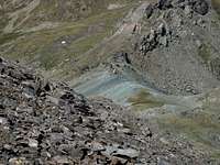
- The Tessonet Glacier (at the foot of the Northwest face of Tersiva) is the only significant glacier of the entire group; not without crevasses, it must be approached with caution and proper equipment
|
|
- Under the Tersiva Northwest face, on the Vallone di Clavalitè side, one can see the Glacier de la Pointe Tersiva; though small, it becomes spectacular with the first snowfalls, appearing as a tormented glacier crossed by many crevasses
|
- Arpisson Glacier, at the foot of the Northern wall of Monte Emilius
- Blantsette Glacier at the foot of the East side of Monte Emilius, above the Lago Inferiore di Laures
- The Laures Glacier, at the head of Vallone di Laures and to the east of the namesake pass, is disappearing
- The Lussert Glacier in Vallone di Grauson, at the foot of the N-E faces of Punta Garin and Monte Grauson and to the west of the namesake lakes, has practically vanished
EXTINCT GLACIERS
- THE LEPPE GLACIER at the foot of the Northern face of Punta di Leppe and Punta di Lussert.
- THE GRANDE ROISE "S" GLACIER at the foot of the Southern face of Grande Roise.
- THE GRANDE ROISE "W" GLACIER at the foot of the Western face of Grande Roise.
- THE PETITE ROISE "N" GLACIER at the foot of the Northern wall of Petite Roise and Punta di Praborna.
- THE PUNTA GARIN "N" GLACIER at the foot of the Northern slope of Punta Garin.
- THE PUNTA GARIN "W" GLACIER at the foot of the Western wall of Punta Garin and Lake.
- THE PUNTA GARIN "S" GLACIER at the foot of the Southern wall of Punta Garin.
Huts and Fixed Bivouacs
| HUTS and FIXED-BIVOUACS |
- Vallone di Arpisson (Cogne) or Pian Bessey: Franco Nebbia fixed Bivouac (2.740m) near Colle Garin (2.815m) at the head of the hanging valley; open year-round, sleeps 6, difficulty of approach: E.
|
|
- Baraka Arno (fixed Bivouac): placed near Punta del Couis (2.661m), open year-round, not equipped for cooking and sleeping; difficulty: E.
|
|
- Comba di Arbolle: Alpe di Arbolle Hut (2.510m) 80 beds, sleeps 18 in winter, 1h'30 from Chamolè (2.311m); difficulty: E.
|
|
- Colle Carrel (along the ridge between Becca di Nona and Monte Ross de Comboè): Federigo Zullo fixed Bivouac (2.907m), sleeps 9, (open year-round); not equipped for cooking; difficulty: E.
|
|
- Vallone di Laures: Ernesto Menabrèaz private Hut (2.542 m) owned by Brissogne Council. It is closed to the public, but has a room, provided with matresses and blankets, that sleeps 8 and is open year-round; difficulty: E.
|
|
- Vallone di Laures: Le Tramail fixed bivouac 1.951m: about at the half of the trail from l'Arp to Menabreaz Hut, open year-round, in good conditions, sleeps 6-8, water in the vicinity difficulty of approach: E.
|
|
- Vallone di Laures: LA VIEILLE fixed bivouac 1.623m: about at the half of the trail from l'Arp and Le Tramail fixed bivouac, open year-round, in good conditions, sleeps 6, water in the vicinity, difficulty of approach: E.
|
|
- Vallone del Grauson: there are no fixed bivouacs or huts in the valley. Tentori Bivouac (2.540m), located in a bulding of Alpeggio di Grauson Nuove, was destroyed by a fire in 2001.
|
|
- Vallone di Comboè: there are no huts or fixed bivouacs, but accomodation is possible in the many hotels of the important ski resort of Pila (1.790m).
|
|
- Vallone di Arpisson: no huts or fixed bivouacs
|
|
- Vallone di Saint Marcel: no huts or fixed bivouacs
|
|
- Vallone dell'Urtier: Sogno di Berdzé Hut (2.526m), località Peradza, at the foot of the Finestra di Champorcher; built recently, in the summer 2005, it was closed; difficulty: E.
|
|
- In the Champorcher Valley, at the border of the Emilius Group on the opposite side of Finestra di Champorcher, there is, near the shore of the Miserin Lake (2.578m), the namesake Miserin Hut, 40 beds, open year-round, unmanned except in August; difficulty: E.
Lakes
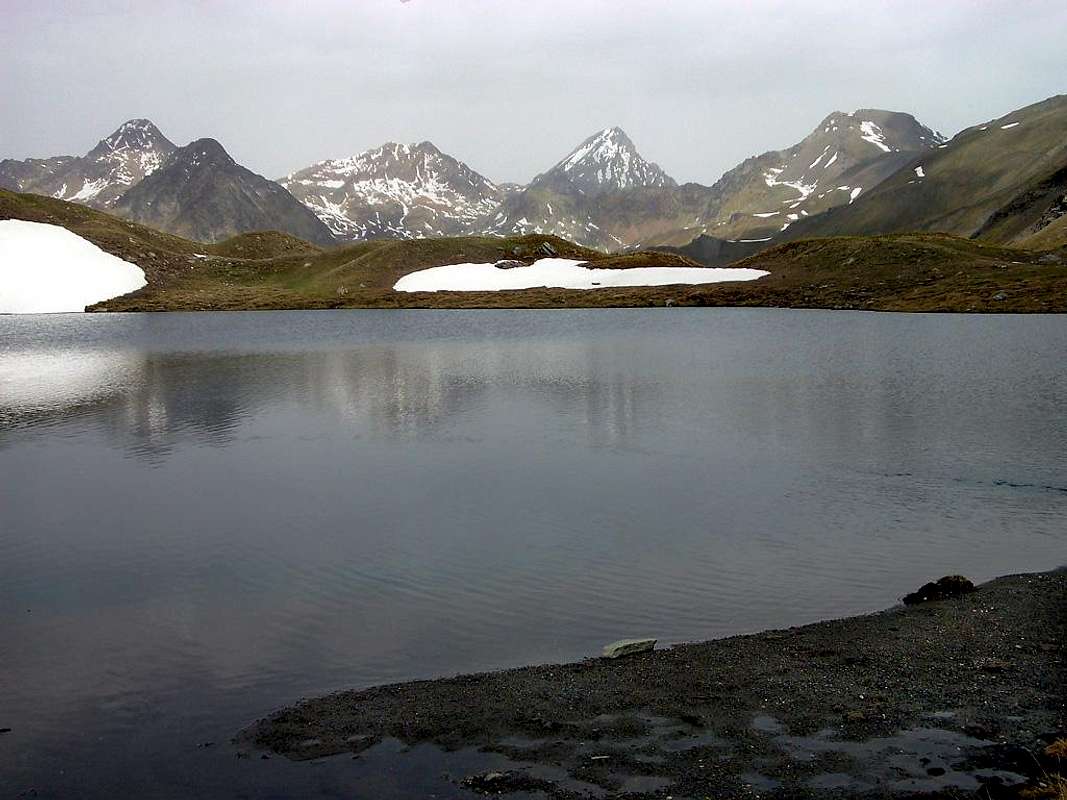
| LAKES of Monte Emilius GROUP
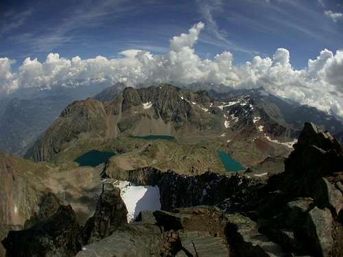
The heart of the Emilius Group seen from the shore of Lago Doreire Superiore
|
| Vallone di Arpisson (Cogne) or Pian Bessey |
|
|
|
| |
| Vallone di Grauson |
|
|
|
|
|
|
|
|
|
- Lago Doreire Inferiore (2.750m)
|
|
- Lago Doreire Superiore (2.844m)
|
|
|
|
|
|
|
|
| |
| Vallone di Lussert |
- Lago Inferiore di Lussert (2.721m)
|
|
- Lago Medio di Lussert (2.800m)
|
|
- Lago Superiore di Lussert (2.907m)
|
|
- Lago Alto di Lussert (2.925m)
|
|
| |
| Vallone di Laures |
- Lago di Laures Inferiore (2.542m)
|
|
|
|
|
- Lago Superiore di Laures (2.787m)
|
|
|
|
|
|
|
|
| |
| Comba di Arbolle |
|
|
|
- Lago delle Capre or de l'Echo (2.702m)
|
|
|
|
|
- Laghetto dei Macigni (2.944m)
|
|
|
|
|
| |
| Conca di Pila |
|
|
|
|
|
|
- Lago di Pian dell'Eyve (2.501m)
|
|
- Laghetti della Testa Nera (2.345-2.365m)
|
|
| |
| Vallone di Arpisson |
- Lago di Arpisson (2.830m)
|
|
| |
| Ridge Vallone di Arpisson - Vallone di Comboè |
- Lago del Colle Carrel or Peckoz (2.818m)
|
|
| |
| Vallone di Comboè |
- Laghetti di Comboè (2.055-2.110 m)
|
|
| |
| Vallone di Saint Marcel |
|
|
|
| |
|
In the vicinity of the Monte Emilius Group, one can mention:
|
| Vallone dell'Urtier |
|
|
|
- Laghi di Pontonnet (2.809-2.819-2.850m)
|
|
- Lago della Torre Ponton (2.745m)
|
|
| |
| Champorcher Valley |
|
|
|
|
|
|
|
|
|
- Lago Pontonnet di Champorcher (2.702m)
|
|
| |
| Clavalitè Valley |
- Lac de Lavodilec (2.356m)
|
|
Climbing Shots
|
|
![]() |
![]() |
![]() |
| Sep 08, 1974 |
Aug 04, 1974 |
Aug 04, 1974 |
Aug 01, 1976 |
|
|
|
|
![]() |
| Aug 08, 1976 |
Aug 08, 1976 |
Aug 08, 1976 |
Aug 08, 1976 |
|
|
|
|
![]() |
| Aug 31, 1980 |
Aug 31, 1980 |
Jul 28, 1984 |
Jul 28, 1984 |
|
|
|
|
![]() |
| Jul 28, 1984 |
Jul 28, 1984 |
Jul 28, 1984 |
Jul 28, 1984 |
|
|
|
|
|
| Jul 28, 1984 |
Jul 28, 1984 |
Jul 28, 1984 |
|
Mountain Conditions
- You can get meteo information at the official site of the Regione Valle d'AostaValle d'Aosta Meteo
Webcam
- WEBCAM on Aosta Valley:
- Webcam
Campings
Remember that free camping is forbidden (except for emergency reasons, over 2.500m, from darkness until dawn).
Books and Maps
BOOKS:
- "Guida delle Alpi Occidentali" di Giovanni Bobba e Luigi Vaccarone C.A.I. Sezione di Torino Volume II (parte II), 25 Maggio 1896.
- "Guida della Valle di Champorcher" e "Guida della Valle di Cogne" di Mario Aldrovandi Ed. Lattes, Torino 1930-1932.
- "Guida della Regione Autonoma Valle d’Aosta" di Mario Aldrovandi; Ed. S.P.E. di Carlo Fanton, Torino 1964.
- "Ascensioni 1964-1969 Diario Alpinistico di Ilario Antonio Garzotto (unpublished).
- "Guida del Monte Emilius" di Osvaldo Cardellina Editore in collaborazione con il Club Alpino Italiano Sezione di Aosta, Dicembre 1978 (in Italian).
- "Guida dei Monti d'Italia–Emilius Rosa dei Banchi Parco del Mont Avic" di Giulio Berutto e Lino Fornelli-Club Alpino Italiano/Touring Club Italiano, Marzo 2005 (in Italian).
- "Diari Alpinistici" di Osvaldo Cardellina e Indice Generale accompagnato da Schedario Relazioni Ascensioni 1964-2019 (inediti).
- "80 itinerari di Escursionismo Alpinismo e Sci Alpinismo in Valle d’Aosta", di Osvaldo Cardellina, Ed. Musumeci, Giugno 1977 (in Italian); seconda Ed. Luglio 1981; terza Ed. Luglio 1984; (in French), prima Ed. Febbraio 1978; seconda Ed. Marzo 1980.
- "Il Parco Nazionale del Gran Paradiso (Valli di Champorcher-Clavalitè-Saint Marcel-Laures-Cogne-Valsavarenche-Conca di Pila" di Giulio Berruto 3/volume 2°, IGC, Torino 1981, 2a Ed. 2000. (in Italian).
- "Ascensioni in Valle d'Aosta 1921-1933" Diario Alpinistico di Amilcare Crétier; Edizione Sezione di Verres del C.A.I. e Biblioteca di Vèrres, stampa Arti Grafiche Tamari Bologna, Luglio 1993 (in Italian).
MAPS:
- Kompass "Gran Paradiso Valle d'Aosta Sentieri e Rifugi" Carta Turistica 1:50.000.
- Hapax Luglio 2000 "Les Sentiers Comunità Montana Monte Emilius" 1:25.000.
- Enrico Editore Ivrea-Aosta "Gruppo del Gran Paradiso" 1:50.000.
- I.G.C. Torino "Carta delle Passeggiate ed Escursioni in V.D.A. Conca di Pila-Gressan" 1:20.000.
Important Information
Useful Numbers
- Soccorso Alpino Cogne (SAR) Tel. 3482685406.
- Protezione Civile Valdostana località aeroporto n° 7/A Saint Christophe (Ao) Tel. 0165-238222.
- Bollettino Meteo (weather info) Tel. 0165-44113.
- Unità Operativa di Soccorso Sanitario Tel. 118.
Acknowledgements
The fundamental support given by my friend Osvaldo Cardellina, probably the best connoisseur of every feature of the Monte Emilius Group (of which he climbed nearly every summit,wall and ridge) has to be emphasized. I want to thank also Fabio (Brenta) for the translation of the text from Italian and livioz for his contribution to the preparation and editing of the page.


 28636 Hits
 97.03% Score
 65 Votes

 Cogne and Prato di Sant'Orso
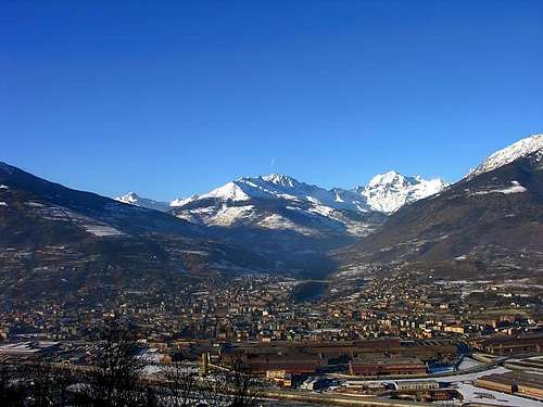 Aosta
Aosta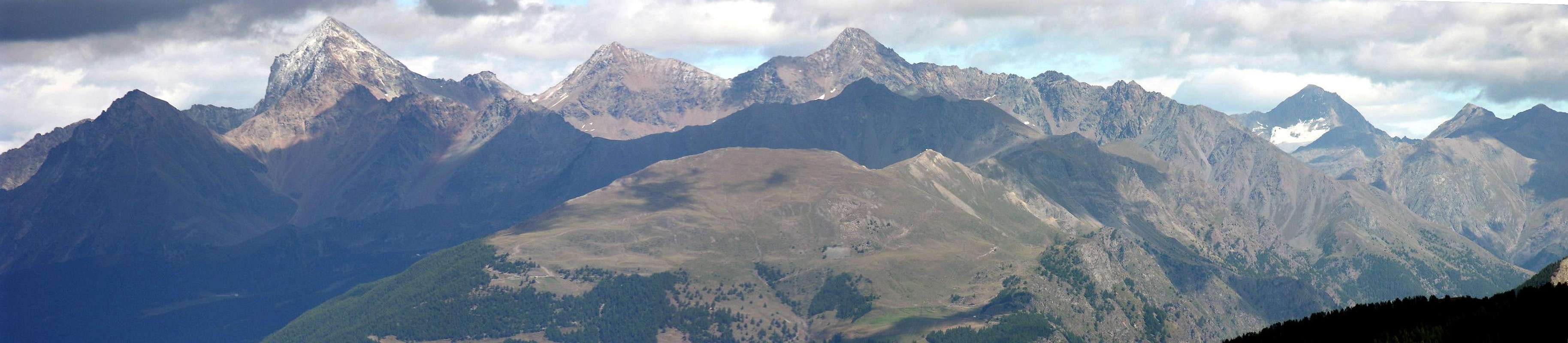
 Vallone di Arbolle
 Vallone di Comboé
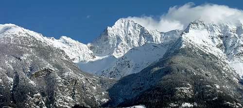 Vallone di Arpisson
 Vallone di Arpisson
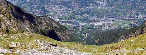 Vallone di Laures or Brissogne
 Vallone di Laures or Brissogne
 Vallone di Saint Marcel