-
 6133 Hits
-
 79.04% Score
-
 10 Votes
|
|
Mountain/Rock |
|---|---|
|
|
40.88100°N / 9.21570°E |
|
|
3067 ft / 935 m |
|
|
Overview
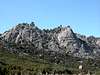
Today’s excursion will lead you back to Domeland Sardinia – the Monte Limbara mountain range which is composed of a large number of beautiful granite domes. For an overview over the range lookup the Monte Limbara page. The most eye catching of the domes are Monte Biancu and Monte Lisgiu which both are located to the north of the range. They are connected by one of the most beautiful hiking trails that I have come to know, a trail which opens up better and better views of the beautiful granite structures, a sheer escalation of beauty. If you are interested visit the Escalation of Beauty Route on the Monte Limbara page.
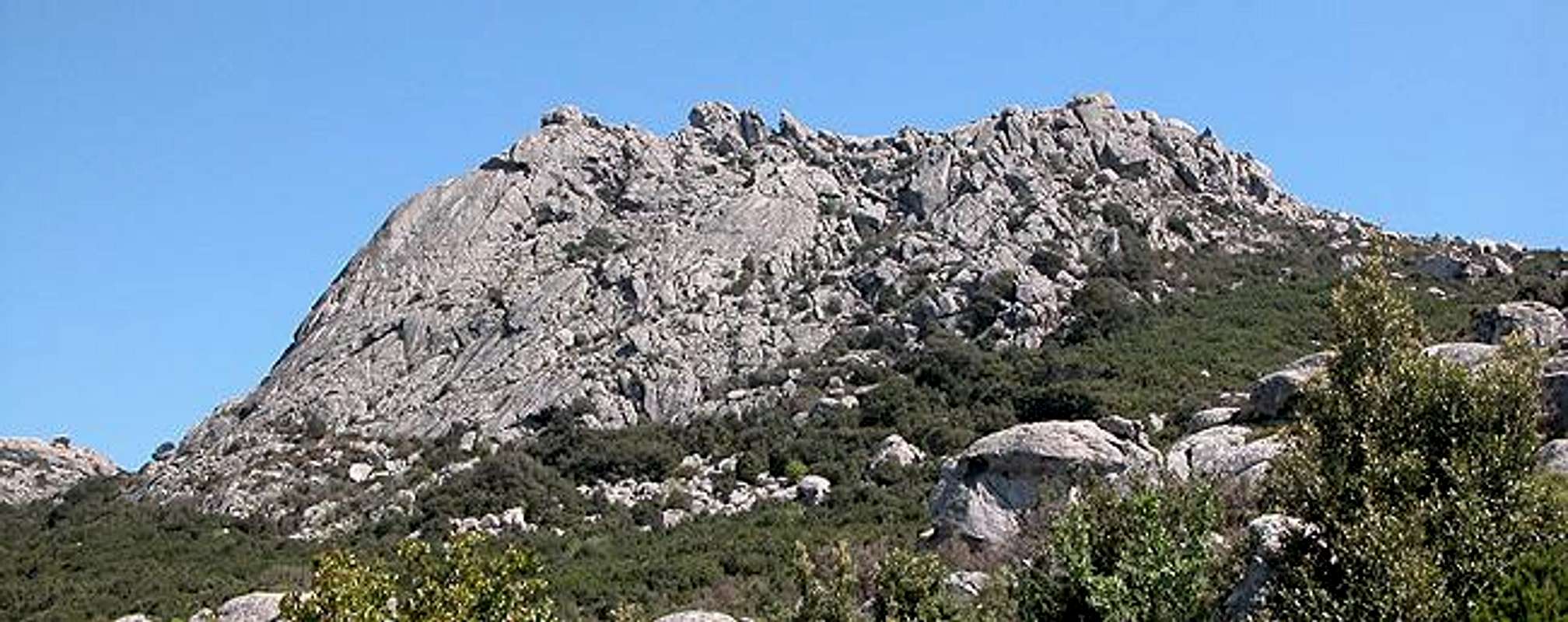
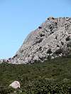
From the trailhead near the ruined train station of Calangianus you can already get a glimpse of Monte Lisgiu, a smooth granite structure which towers above the valley of the river Riu Virtosi. But for its lack of size, from afar Monte Lisgiu somehow tries (hard) to resemble Moro Rock. As for the rock, the normal ascent is very easy. You only need to get up to the plateau side (south) of the mountain from where a short scramble will lead you to the summit. The northern and (especially) western approaches, however, are a quite different matter. Here you will find beautiful solid granite rock faces, some 60° on the northern side while almost vertical on the western one. Climbing routes have a length of up to 200m. Summitpost member sardo established a route here, Lichene Selvaggio which is rated VII/VII- and hasn't been followed up so far.
 |  |
Approaching the mountain might be more of a challenge than climbing it. It is surrounded by dense macchia undergrowth, a thorny mixture of bushes which tries to make up for the injuries it imposes on the hiker by blooming and smelling marvellously. Cutting through the macchia is possible – it actually is quite easy but be sure to wear long pants for the crossing. Otherwise you’ll end up with seriously scratched legs, like I did. And if you encounter some of the nasty Sardinian nettles in that condition you’ll surely think of my advice ;-)
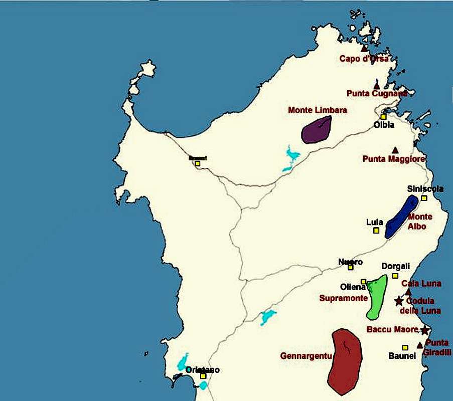
Monte Lisgiu forms a twin summit with neighbouring Punta di li Cupuneddi which is about 100m lower (848m). In contrast to Monte Lisgiu it is not formed like a dome but rather like a heap of large granite boulders which is a reason why it (like so many other places in the Monte Limbara range) is quite popular for bouldering. Both summits are not climbed for the views they offer but on a clear day you will be able to see the Strait of Bonifacio, the narrow gulf between Sardinia and Corsica in the north. To the southwest the view is marred by the TV, radio, satellite and radar installations on Punta Balestreri, Monte Limbara’s highest summit. To the south the views reach towards Punta Maggiore, Isola Tavolara, Monte Albo and (if you are lucky) towards Supramonte.
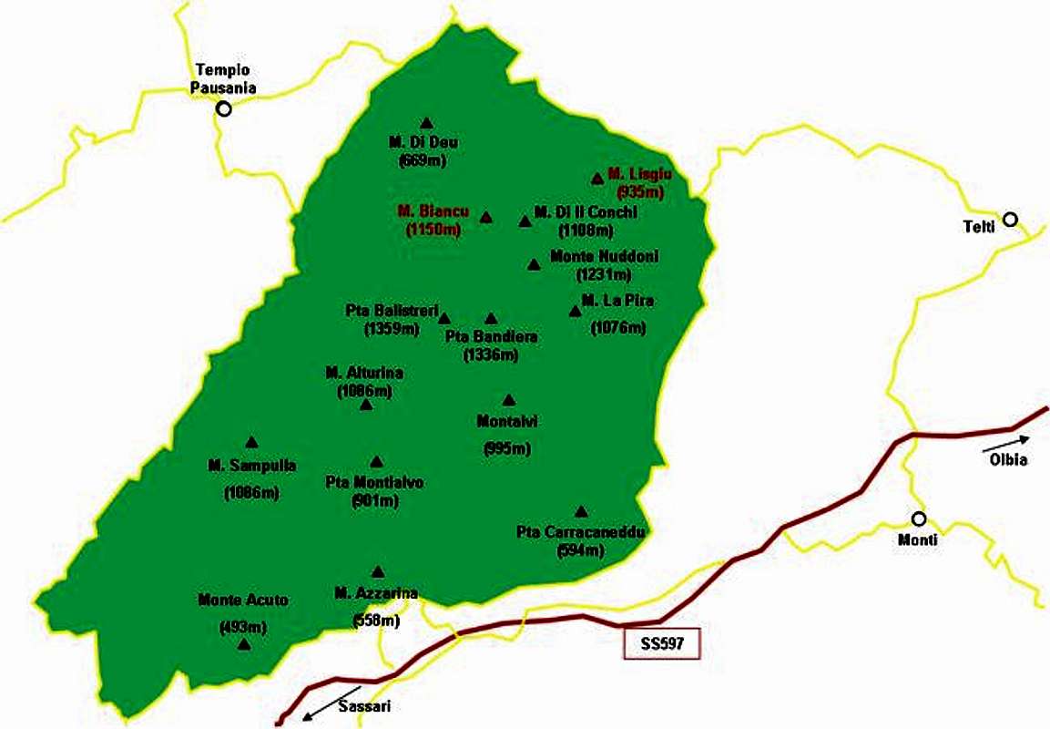
Interactive Map of the whole Monte Limbara range. The summits, which already have been posted to SP are marked in red. The Domeland Region is the range between Monte Lisgiu and Punta Balestreri.
 |  |  |  |
Getting There
Sardinia can be reached either by plane or by ferry. The main ports are Porto Torres and Olbia in the north and Arbatax and Cagliari in the south. Airports are at Alghero and Olbia in the north as well as (again) Arbatax and Cagliari in the south. For exploring the northeastern part of the island where most of the mountains are the best entry point is Olbia, which is where most flights go anyway.
Approaching the mountain from Olbia airport
Get on motorway SS131 north around the city of Olbia on the western side. At the intersection with SS127 turn west into direction Telti. Shortly before you reach Telti, SS127 turns right sharply and heads through the town. At km 30 - shortly before you reach an abandoned train station of Calangianus in a road pass - there is a parking place on the left hand side and it is here that the trails to Monte Limbara start.
Monte Lisgiu lies some 2km southwest of the trailhead. You need to follow the main trail up to a saddle just beneath Monte Lisgiu and then cut through the macchia to get to the base if the granite wall. Alternatively take the second dirt road that leaves to the left and heads up the saddle between Punta di li Cupuneddi and Monte La Trona. The road circles Cupuneddi on the south and can be used for the easier southern approach to the summit.