
|
|
Mountain/Rock |
|---|---|
|
|
41.44961°N / 14.37186°E |
|
|
Roccamandolfi, Isernia |
|
|
Hiking, Mountaineering, Mixed, Scrambling, Skiing |
|
|
Spring, Summer, Fall, Winter |
|
|
6726 ft / 2050 m |
|
|
Monte Miletto
Monte Miletto (2,050 m / 6,725 ft) is the highest peak of the Matese massif and the entire Appennino Sannita, the northern most spur of the Southern Apennines (Appennino Meridionale). The Matese massif is enclosed by the valley of the Volturno river and the Molisan Pre- or Sub-Apennines. From the summit the view goes over the Tribulani mountains, the Taburno Camposauro massif, Le Mainarde (and Monti della Meta) and, to the north-west, the peaks of the Majella massif.
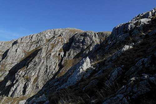
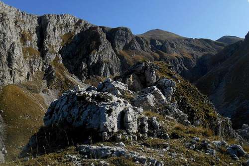
To the north, at Campitello Matese, the mountain has been under assault since the 1970s by the construction of nasty blocks of hotels and an extensive ski resort. On its foresummit a small radio station was built, too. Nevertheless, the mountain's south, north and northwest routes are passing through beautiful, uncontaminated and secluded valleys that preserved their natural aspects. They are rarely frequented and offer splendid views. The most impressive characteristics, perhaps, are the geological features of the three glacial cirques of Colle Tamburo (north west), the gorge-like Fondacone valley (north) and the karstic plateau 'Campo del Arco' (south) which shows, as its name indicates, also a small natural arch.
Interesting to learn is the fact that this mountain, being exposed to very different wind currents, can receive quite different types of snow during the winter months. Unlike with many other mountains of the Apennines, here the snow will not so easily slide down from the steeper walls and expose the underlying rock. It can sticks to the rugged surface for quite a long time, forming even icy cascades and thus offering diverting routes for mixed and ice climbing.
 Escarpment of the Fondacone valley | 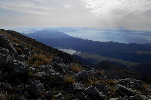 The valley of Lago del Matese | 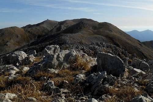 Monte Miletto from its north-west ridge |
Other interesting areas of this mountain range include the extensive moraine landscapes and glacial cirques of Colle Tamburo (1,982 m), the peaks of La Gallinola (1,923 m), Monte Mutria (1,823 m) e Monte Erbano (1,385 m).
Routes
1. From the north-west (from Roccamandolfi)
1.1 The north-west ridge - via Colle Tamburo (red)
Trailhead for the north-west route is the mountain hut Rifugio Guado da Melfa (1,303 m). You may leave the car at the end of the narrow asphalt road. Follow the forest track which passes a large clearing with a picnic area before starting to ascend in a south-eastern direction. Before long you will reach a second clearing. Here, look for red/white signposting on the trees. The actual hiking path starts immediately to your left and traverses the forest before descending again (left) towards a vast glade.
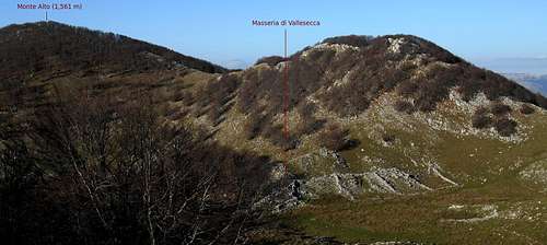
Masseria di Vallesecca
Where you encounter a number of small enclosures for livestock you have reached the plateau of "Masserie di Vallesecca", the ruins of a former farmhouse. From here there is no real path recognizable any more. The signposting seems somewhat discontinued and is not following any logical line. Some passages of an easy scramble will occasionally alternate with ample dolinas and narrow rifts.
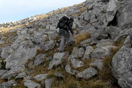 On the trail | 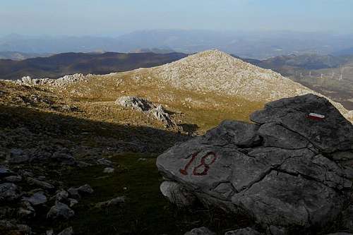 Signposting (north-west route) |
Sticking to the ridge you will certainly come upon the red/white marks, or a red "18", painted on large rocks. Even if you should lose the trail altogether, keep with the ridge (to your right) that inevitably will lead you up to the peak of Colle Tamburo from where you can pick up the trail, or continue in a direct line towards Monte Miletto, already in sight. Though the information board reckons 4 1/2 hours (one way), you might make it also in about 3 hours from the trailhead to Monte Miletto.
1.2 and 1.3 Alternative routes - Cirques of Colle Tamburo (green) and Monte Miletto via the north shoulder (blue)
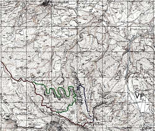
Northwest route and alternatives
Indeed, it is always skirting the northern flank of the mountain (Colle Tamburo) whose steep escarpments delimit the three glacial cirques of the valley Folubrico.
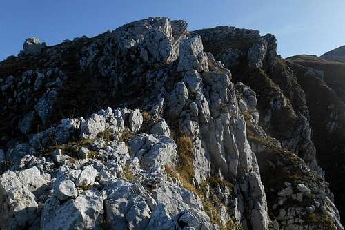
Turning for the 3rd glacial cirque you will instantly spot the "Campanarielli", a twin rock formation with a very distinctive shape. The lower and more tapered Campanariello di Valle (1,602 m) is connected with the slightly higher and somewhat broader Campanariell di Monte (1,634 m) only by a narrow ridge. Both can be climbed and make a perfect spot from which to take pictures of the deep ravines and cirques surrounding them.
However, their rock quality is actually bad, i.e. very friable, and the exposure, especially towards the side of the Fondacone valley, is everything but indifferent.
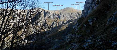
From the uphill side of Campanariello di Monte you might either ascend towards the the moraine plateaus of Colle Tamburo (south, south-west) or traverse the Fondacone gorge and follow a barely visible trail that traverses a scree ramp and a narrow ledge before ascending towards a breach in the wall of the north shoulder of Monte Miletto. Once on the shoulder, simply follow the crest to the foresummit and summit.
3rd cirque of the Folubrico valley
Though arguably one of the wildest spots and, not least from a geological point of view, the most interesting area of the entire Matese massif, the glacial cirques of Colle Tamburo, the Folubrico and the Fondacone valley as well as the moraine landscapes further uphill are not often frequented.
2. From the north (from Campitello Matese)

Campitello Matese
2.1 Campitello Matese - Monte Miletto
This is considered to be the "normal route" to Monte Miletto, and it is by far the most beaten ascent route. From the parking area at Campitello Matese (1,417 m) it should not take you much longer than 1 1/2 hour to cover the mere 2,5 km to the top of Monte Miletto. There is some signposting (red/yellow), but this is actually not needed with fair visibility conditions.
However, due to the presence of the not so beautiful ski resort (an huge aggregation of blocks of hotels) and the inevitable platter and chair lifts etc. this route is by no means the most recommendable one, neither in winter nor in the off season.
2.2 and 2.3 Alternative routes from the north
On the other hand, you might very well start from Campitello Matese but avoid the direct north route and follow instead a trail that circumnavigate the northern extensions of Monte Miletto in direction of the location "Pianta del Melo". From there it is possible either to continue towards Serra Soda (1,552 m) and ascend the long crest that leads to the foresummit and the summit of Monte Miletto, or to explore the valley Valle Fondacone and follow the narrowing ravine to the moraine landscape that stretches between Monte Miletto and Colle Tamburo.
Of course, both of these alternatives are much longer. They will take you several hours more and do require a certain sense of direction. From Monte Miletto you may descend via the "normal route" in order to get back to your trailhead at Campitello Matese.
3. From the south (from San Michele, Lago del Matese)
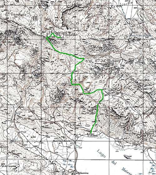
South route (from Lago Matese)
The south route starts in the vicinity of the lake Lago del Matese. The trailhead is close to the small chapel of San Michele (1,014 m). There is also a nearby fountain where you may fill your water supplies.
The trail is about 5 km long (one way) and is well signposted with the usual red/white marks and the number "13" (or "13D"). Therefore it should not present major orientation issues and the ascent should be manageable in roughly 3 hours time.

Lago Matese
Alternatively (light green on the map) it is also possible to follow a trail that skirts Colle del Monaco on its south side and leads to the moraines of a karstic plateau where it is possible to visit the sinkholes and the natural arch of 'Campo del Arco' (1,536 m).
From the plateau the trail gets steeper as it keeps ascending in a northwesterly direction, towards the peak of Colle Tamburo. At an altitude of approximately 1,900 m it takes a sudden turn to the right and follows the south ridge to the top of Monte Miletto. This passage, almost beneath the summit, is fairly steep but never exposed.
A sketched route map and other quite detailed maps of interesting hiking trails around the Matese massif can be found on the official page of the the CAI (Italian Alpine Club) Piedimonte Matese.
A few landmarks & impressions
 Valle Fondacone - from Campanariello di Monte | 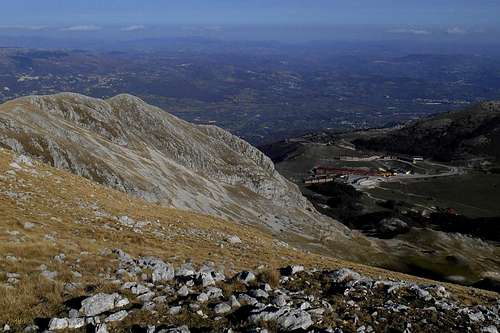 Campitello Matese (seen from foresummit) | 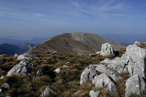 Colle Tamburo (seen from the ridge) |
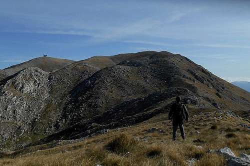 Monte Miletto - seen from the northwest ridge | 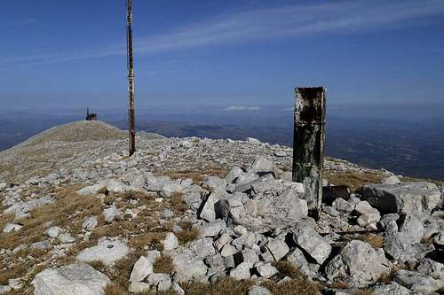 Monte Miletto (the summit) | 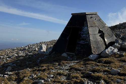 Emergency shelter on the col |
 Ridge between Fondacone and Folubrico valley | 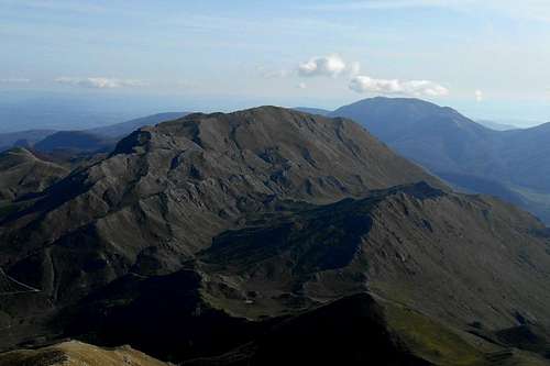 La Gallinola - seen from Mt. Miletto | 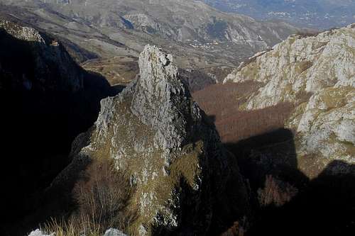 Campanariello di Valle and Fondacone valley |
Getting There
The nearest international aiports are Naples (ca. 2 hours, 150 km) and Rome (ca. 3 hours, 250 km). From either starting point take the superhighway A1 (Milano Napoli). If coming from Rome take the exit "San Vittore", if from Naples take the exit "Caianello", and follow indications for Isernia (state road SS85).From Isernia take the state road SS17 in direction Campobasso. Turn right at the location Cantalupo (for Roccamandolfi) or at San Massimo (for Campitello Matese). From the latter is also possible to continue on the provincial road SP106 in direction Lago Matese, f.e. if you would like to approach the mountain from the south.

Matese massif on the map
From Roccamandolfi (i.e. for any of the north-west routes) stick to the asphalt road and follow indications for Longano and, at the junction turn left for "Campitello di Rocca" and the mountain hut Rifugio Forestale Guado la Melfa which is not signposted. The road itself is in rather poor conditions, betimes very narrow and without any railing. Best to leave the car at the mountain hut, right beside the road.
Red Tape
The Matese massif is part of a so-called regional park (Parco Regionale del Matese), which basically means that it is no national park. However, be reasonable - don't litter and keep in mind that no open fire is allowed. Different additional rules may have been established by the local municipalities. No parking fees at any of the mentioned trailheads.
From the cracks ...
For your own safety: During the hunting season (usually in late autumn) make sure to wear bright colors, or a bring a safety vest and wear it when moving anywhere below the timber line. The local hunters are rather infamous for their recklessness. Severe and even fatal hunting accidents have been reported occasionally over the last years.
When to Climb
Monte Miletto and the other peaks of the Matese massif can be climbed all year round. During the winter month ice and firm snow are very common, so basic mountaineering gear (ice axe and/or crampons) might be required. Signposting is deficient (red and white signs on larger rocks) and with fog, low clouds or deep snow orientation can become quite problematic, especially when approaching on the hiking trail from the northwest.As pointed out already, the north and northwest face of Monte Miletto and its foresummit also offer some short but still interesting mixed and ice climbing routes.
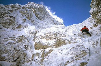
Mixed route on Monte Miletto*
*Source: www.planetmountain.com
For a list of short mixed and ice climbs on Monte Miletto see f.e. the respective link at the bottom of this page.
Accommodation, mountain huts, etc.
Accommodation can be found at Isernia (about 15 km form Roccamandolfi), but also at Castelpetroso (about 7 km), San Massimo (about 5 km) or at on of the hotels of Campitello Matese, or the Rifugio Jezza (tel. 0874 784188 - www.rifugiojezza.it), also to be found at Campitello Matese. The nice little town of Roccamandolfi itself unfortunately seems not to have any accommodation to offer.
Roccamandolfi (IS)
The only camping ground of the area is located at Castello del Matese, a few kilometers south of the lake Lago del Matese, in vicinity of the small town Piedimonte Matese.
In case of suddenly deteriorating weather conditions, there is some kind of wooden emergency shelter on the col between Monte Miletto and its northern foresummit. The shelter is in bad conditions, has no door and should be considered only in extreme situations (f.e. sudden thunderstorm).
Maps, guide books etc.
Strange enough, but apparently there is no reliable/detailed map or guidebook available for purchase.* Also earlier editions of both maps and guidebooks are hard to find. Best (and possibly the only) choice might still be the maps from the IGMI, keywords: Piedimonti Matese (new edition), Roccamandolfi (old edition). These maps (scale 1:25,000) can also be ordered online, f.e. at www.maps-store.it.*If you should know of any relevant publication, please contribute by posting a comment with additional information.
External links
- Matese Regional Park - official page of the regional park
- Fallode village - camping ground, guided tours etc.
- Campitello Matese - offical page of the ski resort (with additional information, weather conditions, web cam images etc.)
- CAI Piedimonte Matese - itineraries etc. available from the CAI Piedimonte Matese
- planetmountain.com - a list of short mixed and ice climbs on Monte Miletto
- francescoraffaele.com - great variety of galleries with images and impressions from the Matese massif