
-
 1831 Hits
-
 73.06% Score
-
 3 Votes
|
|
Route |
|---|---|
|
|
46.29666°N / 13.24475°E |
|
|
Hiking, Scrambling |
|
|
Spring, Summer, Fall |
|
|
Half a day |
|
|
medium hard hike up |
|
|
Rating the Route (By Hiking Standards)

The southern slopes of Monte Postoucicco / Postovčič
The grading system for hiking and scrambling routes is here.
0. General: From 800 m to 1611 m, exposition N and E. At first a comfortable hike by a well beaten mountain/shepherd path on Tazaoro / Tam za goro meadow, then a tiny, well marked mountain path on Dolina notch, finally a more or less pathless terrain (a few marks) to the summit.
1. Effort: cca 820 m, 2 h 30 min.
2. Power: 2 - Easy.
3. Psyche: 2 - Easy (no bigger exposition).
4. Orientation: 3 - Medium hard (a few riddles below the summit).
Getting There
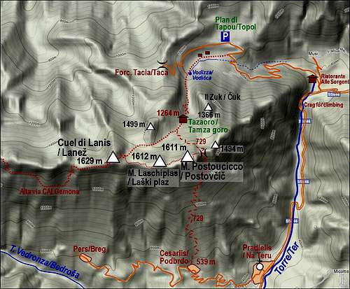
See the parent page of Monte Postoucicco / Postovčič how to get on the mountain road below Plan di Tapou / Topol. We park on 800 m.
Route Description

Tazaoro / Tam za goro alpine meadow
We best start on the road, where the marked path No. 729 deters from it. At first it goes in the W direction by an abandoned cart-road. We pass 3 or 4 ruines, the last ones are in a better condition, but still abandoned. They are all in a young forrest, indicating that once there had to be perhaps a mountain meadow. The marked path leads us through dense plantations of nettles, finally the unpleasant green nuisance is over and we reach a good water source, named Vidizza/Vodičca. Here also the lower path comes from the left - so over the ex Tacia/Taca alpine pasture. From the source on, a good path goes in the southern direction. Mostly it uses a karstic shallow valley, ascending gently through the woods, later the ascent becomes steeper and in a few turns the path overcomes the valley step and reaches Tazaoro / Tam za goro alpine meadow, 1264 m. Two houses are renewed, the place is very idyllic. Towards the north we can already enjoy a nice view on Musi/Muzci range.

Dolina notch
The path continues ascending by the alpine meadow west of the houses. The meadows are steep, so on the upper part we are already some 50 m above the houses. There the marked path are branching. Towards the right, in the SW direction, the Alta via CAI Gemona goes on Cuel di Lanis/Lanež. It is marked with red circles. If we attempt also the ridge tour, we shall return there. The path No. 729 continues southwards, the inscription is to Dolina notch. That is the shortest route on Monte Postoucicco / Postovčič. The path is first winding through a karstic forrest, then starts to go more in the SE direction. Above, very nice view opens towards the north and the path does again some crossing towards the left. Finally it ascends Forcella Dolina (notch), some 1500 m. Deep below, on the southern side of the main ridge we see the villages and forehills around Torre/Ter river.

Towards the summit
On the notch we leave the path No. 729. Tiny marks and very weak traces lead us towards the west, up the ridge. At first we go by the ridge, which becomes narrow. Grassy slopes require some care, especially if they are wet. Soon a steep grassy and rocky barrier rises in front of us in the ridge. Don't attempt to climb it! The route goes down a bit (ciarns), if you look carefully, you will find also a few old, washed out, red marks, which bring you on the northern slopes of the fore-summit. There you go very steeply up, pulling with hands (pine bushes are helpful). Finally you reach by a grassy slope the fore-summit with a small cross. The main summit is close to you in the western direction. You ascend it by a similar steep, unpleasant terrain, but the route is safe enough. The quickest descent goes by the same route. Still, many visitors decide to continue by the main ridge towards the west, over Laški plaz, 1612 m, on the summit of Cuel di Lanis / Lanež. From there we can return by Alta via CAI Gemona.