
-
 4284 Hits
-
 79.04% Score
-
 10 Votes
|
|
Mountain/Rock |
|---|---|
|
|
42.16539°N / 13.89941°E |
|
|
Download GPX » View Route on Map |
|
|
Hiking |
|
|
Spring, Summer, Fall |
|
|
5679 ft / 1731 m |
|
|
Overview
 Monte Rotondo summit with heavy weather developing behind Monte Rotondo summit with heavy weather developing behind |
La Montagna del Morrone is a north-west to south-east running chain, which rises abruptly above Val Peligna in the Abruzzo region of central Italy. With summit altitudes of more than 2000m the elevation difference to the valley floor (less than 300m) is huge, limiting the number of visitors to those areas where easily reachable high trailheads can be found. The chain stretches for more than 15 km between the Gole di Polpoli in the north and Passo San Leonardo in the south-east. This latter pass separates Montagna del Morrone from the higher Majella Range, to which nevertheless it is associated. Both ranges have been included into Majella National Park (Parco Nazionale della Majella).
Montagna del Morrone consists of a chain of several summits, starting with Monte Mileto (1920m) in the south-east, culminating in Monte Morrone (2061m) in its centre and ending with Monte Rotondo (1731) in the north. The chain is made up from compact limestone, which can be seen on Monte Rotondo`s summit block, which barely rises above the meadows of the Morrone Chain. Also it is home to rare plants like orchids, gentian or wild peonies.
 |  |  |
As stated above, the elevation difference to reach Monte Rotondo is huge, in spite of its moderate elevation. You will have to scale around 1400m at distances of close to 20km. However, there is a mountain hut, Rifugio del Monte Corvo beneath its western base, which serves as a relais for 90% of summit hopefuls, those who start from Val Peligna in the west. To reach the summit you have to traverse a surprisingly rocky ridge, which culminates in a handful of summit blocks which have small vertical faces on their western side.
 |  |  |
Monte Rotondo offers good views across the plains in the west wich Velino-Sirente, Gran Sasso and Majella on display. On good days you can see both Italian coasts from the summit.
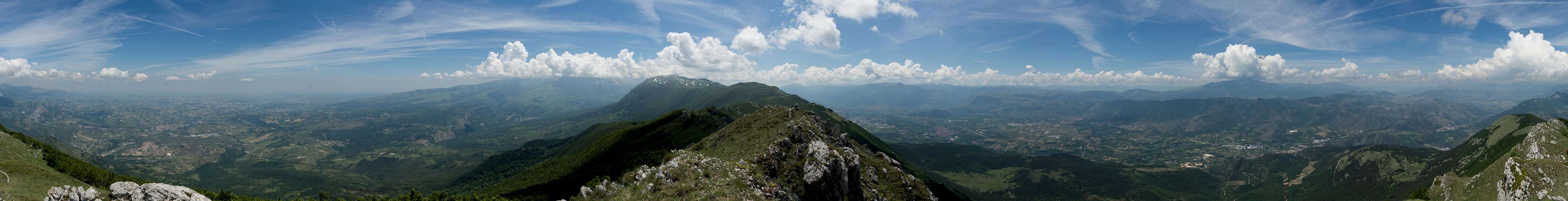
360° Summit Panorama
  |
Getting There
 Val Peligna seen while ascending Monte Rotondo
- From Rome:
- Take motorway E80 / A24 from Rome to Torano.
- Switch to motorway A25, direction Pescara.
- At the exit Pratola Peligna / Sulmona switch to SS17 to the trailhead at Roccacasale.
- Alternatively wait until the exit Casauria / Torre de Passeri, where you switch to SP71 to Tocco da Casauria The Parking lot is above the village.
- Take motorway E80 / A24 from Rome to Torano.
- From Pescara
- Take motorway E80 / A25 westward in direction Rome.
- At the exits Casauria / Torre de Passeri or Pratola Peligna / Sulmona turn of for your trailheads at Tocco da Casauria or Roccacasale
- Take motorway E80 / A25 westward in direction Rome.
Routes
 Scrambling on the Monte Rotondo north ridge
There are two trailheads, one at Roccacasale in the west, one at Tocco da Casauria in the east. All routes scale more than 1400m of elevation.
From Roccacasale to Colle dei Sambucchi
From the village follow a dirt road in direction of Rifugio del Monte Corvo, which you leave at Laghetto della Rocca A number of steep switchbacks take you to the source Fonte della Rocca, then even steeper through a forest of ancient beeches to the Montagna del Morrone Main Ridge. Turn northwest and follow the ridge across Colle dei Sambucchi (1638m) and Montagnola (1649m) to Monte Rotondo (1731m).
From Roccacasale to Rifugio del Monte Corvo
Probably the most popular route follows the same dirt road (see above) to Laghetto della Rocca. Stay on the road, which slightly descends into Valle Grande. Here turn right onto another dirt road which directly heads for the rifugio. A slope traverse northwards leads to the Morrone Main Ridge on which you turn to climb to Monte Rotondo. At first the trail stays on the western side of the ridge but once it gets rocky the path turns to the east.
From Tocco da Casauria across Monte della Grotta
Starting from the parking lot above the village (used by hanggliders in the afterrnoons) follow an overgrown path (some muddy bushwhacking here) which leads in long switchbacks through the forests on the eastern side of Monte Rotondo. After long hours of hiking you get to the plateau of Monte della Grotta which offers the first decent views across Gole di Popoli. Now the path traverses a steep slope towards the northern part of the Morrone Main Ridge. Turn south onto the path which crosses the meadows west of the ridge until you get to the rocky summit block. Switch to the eastern side ans scramble up the limestone summit block.
Red Tape
 |  |  |
Monte Rotondo is part of Parco Nazionale della Majella. Additionally it is protected by Riserva Statale Monto Rotondo. The usual restrictions apply. For more information see the park's websites
Accommodation
 Tranquility and solitude at Rifugio del Monte Corvo
There's ample accommodation'options in the area, however rather hard to find. Google searches often end up at the tripadvisor, casamundo or booking.com portals. There is a thriving community of British expatriates, many of whom offer apartments for rent. Maybe a good starting point is this site
welcometosulmona.com
Weather Conditions
Maps & Books
Maps
- Digital Maps
- Regular Maps
I haven't been able to find a map for Montagna del Morrone. The southern part can be found on a map for Majella by Il Lupo but the northern part around Monte Rotondo is missing. However, the guidebook below comes with tour maps which helps a lot.
Books
- Abruzzen
Heinrich Bauregger
Rother Verlag
ISBN 978-3-7633-0413-2
- Abruzzen