
-
 6639 Hits
-
 77.48% Score
-
 8 Votes
|
|
Mountain/Rock |
|---|---|
|
|
45.94792°N / 10.77254°E |
|
|
Hiking |
|
|
Spring, Summer, Fall |
|
|
7057 ft / 2151 m |
|
|
Overview
 Monte Tofino seen from Corno di Pichea Monte Tofino seen from Corno di Pichea |
Monte Tofino, together with its neighbour Corno di Pichea, can be called the central mountain of a ridgeline which lies in the triangle between the lakes Lago di Garda, Lago di Ledro and Lago di Tenno. The ridge starts at Rocchetta Giochello (1540m), runs west to Cima Pari (1991m), where it turns north Across Monte Tofino (2151m) and reaches its highpoint in Dosso della Torta (2156m). It later runs out across Gaverdina (2047m) and Monte Altissimo (2128m) towards Tione di Trento. The mountains on the ridge are a queer mix between steep grass mountains and vertical limestone rocks with a lot of bizarre karst formations in between.
 |  |  |
Monte Tofino is a specimen of the steep grass mountains. It has a long stretched ridge running north to south. As second highest mountain on the ridge after Dosso della Torta it commands great views, mainly towards the Adamello- and Brenta Groups. The mountain can be reached from three trailheads, Malga Trat and Malga Pranzo always higher up the mountains and the village of Ballino, north of Lago di Tenno. None of the trailheads is particularly close but a wonderful ridge traverse certainly makes up for it.
 |  |  |
The whole ridge to which Monte Tofino belongs, saw severe fighting in WW I. It was fortified and held by Austrian troops, who faced off against Italian Alpini on the other side of Valle di Ledro. Many of these fortifications, caves, bunkers, trails can still be seen and used today and while the more prominent routes have been turned into Vie Ferrate (at Rocchetta Giochello), most of them were turned into Sentiero della Pace, a peace trail commemorating the war. The summit of Monte Tofino is devoid of any fortifications but the traverse towards Dosso della Torta clearly follows the old support trails of the Austrian troops. They are all located on the eastern side of the mountain, hiding from view from the former Italian fortifications to the south and west. There are several caves along the crest and a wonderful ledge traverse high above the mountain's very brittle east face.
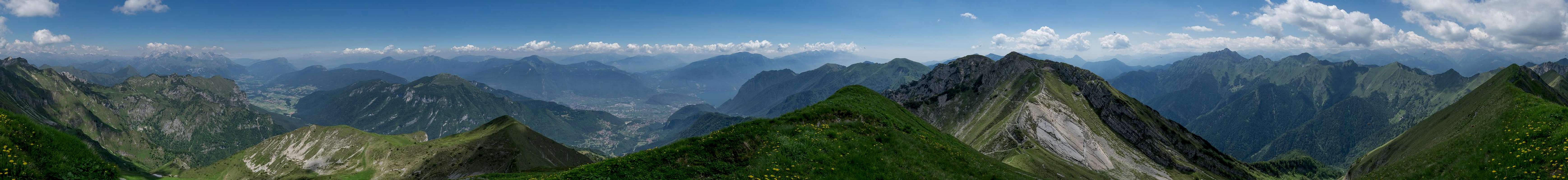
360° Summit Panorama
  |
Getting There
 WW I trail above the east face of Monte Tofino
There are three trailheads for Monte Tofino, Malga Trat, Malga Pranzo and the village Ballino.
- Malga Trat
- On Brenner Motorway A22 take the exit Roveretto Sud
- Switch to SS240 to Riva del Garda
- After the town follow the signs to Valle di Ledro still remaining on SS240.
- Drive through two tunnels and after Pieve di Ledro switch to SP119 into Valle Concei
- At the end of the village Lenzumo turn right onto a mountain road to Malga Trat. It ends some 800m before the farm.
- Malga Pranzo
- On Brenner Motorway A22 take the exit Roveretto Sud
- Switch to SS240 to Riva del Garda
- After the town switch to SP37 to Pranzo
- Turn left onto SP37dir to Campi
- Take the dirt road to Malga Pranzo
- Ballino
- On Brenner Motorway A22 take the exit Roveretto Sud
- Switch to SS240 to Riva del Garda
- After the town switch to SP37 to Pranzo and SS421 to Ballino
Red Tape
 Anemone narcissiflora
There's no Red Tape, perhaps a bit of private property around the farms but otherwise unspoilt. The WW I trails have been renovated recently(?), try to keep them in shape.
When to Climb
The best time is early summer through late autumn.Accommodation
Weather Conditions
 Monte Carè Alto
Maps & Books
Maps
- Digital Maps
- Regular Maps
- Alto Garda - Ledro - Monte Baldo
Tabacco Map 061
Editione Tabacco
1:25000
ISBN: 978-8883151057
- Alto Garda - Ledro - Valle del Sarca
Kompass Map WK096
Kompass Verlag
1:250000
ISBN: 978-3850264921
- Alto Garda e Ledro
Kompass Map WK690
Kompass Verlag
1:250000
ISBN: 978-3854917724
- Alto Garda - Ledro - Monte Baldo
Books
- Gardaseeberge
Heinrich Bauregger
Rother Verlag
ISBN: 978-3-7633-4256-3