Well...
I didn't make it all the way to the Crags TH. No, for some reason my car got stuck in a few inches of snow. At least it wasn't in the middle of the road. I left it there at 7, hoping the snow would melt by the time I returned. Anyway, no problem--what's another mile?
The road was pretty icy, and I foolishly thought I wouldn't need my snowshoes, so I left them with the car. After the first bit of trail I was patting myself on the back for not bringing the extra weight. And then I started to sink; and then I pulled my lower calf muscle. But it didn't hurt really, so I kept going.
![Approaching Treeline]() This is where the snow started getting deep
This is where the snow started getting deepMake your own trail
Because of the winds, the trail disappears around treeline. I started following some ski tracks up a pretty steep hill. I have a feeling it was a detour. In fact, nothing I saw looked like the photos in the 14ers.com route description. But I knew I could follow the long ridge to Devil's Playground and eventually Pikes Peak, so I just started making lines to the next hill.
Along my path there were lots of nifty rock formations, which conveniently served as shelter from the brutal winds. Apart from these rocks there is nothing to break the wind as it blasts across the ridge longways, resulting in flying ice crystals and ridiculous snow artifacts. I tried to photograph some of these but my camera got too cold and started crashing intermittently.
![Rock Formations]() These make great waypoints
These make great waypoints![Cold & Windy]() 20 minutes of pure agony to the next rock cluster
20 minutes of pure agony to the next rock clusterThe last 500' is always a b****
I reached Devil's Playground about 10 am and shortly thereafter got my first good view of the summit. I had not seen another soul since I began the ascent and I knew there were people up there; truth be told I was feeling pretty remote after crossing all those vast bitter cold, windy, snow-covered hills.
Despite increased irritation in my leg I pushed on to reach the base of the final rocky slope around 11:15. Here I felt absolutely spent. After I sat down faintly dizzy I realized I hadn't had any sugar at all and demolished a cherry pop-tart. That did the trick, although it still took an hour to climb the hill.
Yay summit! There was no train, but the store was open so I went in to say hi. They gave me a hot chocolate. That was like a breath of new life, and soon I was ready for the descent, or so I thought.
![More Rocks]() Looking back as I approach Devil's Playground
Looking back as I approach Devil's Playground![Devil s Playground]() The old road to Devil's Playground is scarcely visible
The old road to Devil's Playground is scarcely visible![You may have to step over a cable...]() The 14ers route description notes you may have to step over a cable to reach Devil's Playground. You may choose to do so. =)
The 14ers route description notes you may have to step over a cable to reach Devil's Playground. You may choose to do so. =)![Pikes Peak]() Summit in view!
Summit in view!![Devil s Playground Area]() Looking back towards Devil's Playground area
Looking back towards Devil's Playground area![Another View NW from Pikes Peak]() Finally on the summit
Finally on the summitMaking a mess and fixing it
The wind had completely erased my tracks as expected. I was certain I had hugged the part of the ridge nearest the drop into the valley to the North. I also remembered which rock formation I had encountered upon emerging from treeline. Thus, when I came over the last slope I was surprised it wasn't there. This was a major blow as my leg was getting stiff and I was all-too-ready to pick up my trail below treeline and get out of the wind.
I looked to the south and saw two rock clusters at some distance, with a deep gully between them which separated me from the farther one. I tried to believe the one closest to me was my landmark and I made for it. It wasn't the right one, as I already knew, and I had to cross that gully because I didn't want to reclimb with my leg. The traverse down into the gully was probably 70 degrees, all powder--couldn't have
climbed that on a good day. Very stupid.
Once on the other side I picked up a snowshoe trail from a group I encountered who had also started from Crags. But I lost the trail just above treeline. Again not wanting to aggravate my leg, I pressed on anyway and was soon bushwhacking, expecting to cross the ski tracks at any moment. When I didn't find them, I felt they were further west and turned to go that way. After a few steps I caught myself. Sat down, ate my other pop-tart, drank some water, and just sat a few minutes. Got up, turned around, reclimbed out of the forest, and located the tracks again, which led east. Had I continued on that other course, I would not have found any trail.
Better late than never! 9 hours, 30 minutes, and 14.4 miles later, I returned to my starting point.
Note: Although I had my GPS on me, I was unable to view my route. I considered making a beeline for the trailhead but realized I knew nothing of the terrain involved.
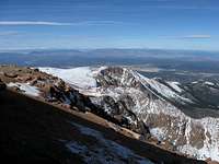
![Cliffs on Pikes Peak Trail]() Cliffs above the valley to the north
Cliffs above the valley to the north![My Route to Pikes Peak]() Looking back on my route to the summit
Looking back on my route to the summit


Comments
Post a Comment