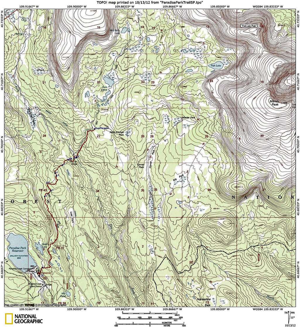
Most complicated trail directions ever
This is a map of the trail leading from Paradise Park in the direction of Fish Lake. I turned off of it several miles before Fish Lake. The part I was on was well maintained but had four unsigned junctions and nine junctions in all.
The trail starts just before the campground loop.
At J1 (unsigned but obvious) the trail makes a sharp right. An abandoned road littered with many downed trees continues straight.
At J2 there were 2 signs. Take the Dry Fork Trail.
At J3 the trail came to a T intersection with a dirt road with no indication of whether to go left, right, or across into the woods. The correct way is left along the road for .16 miles where you will come to J4.
At J4 there is a nicely signed intersection. Turn right along another dirt road heading towards Red Belly Lake and Trail 051.
At J5 (signed) a road joins to the right. Continue straight in the direction of Dry Fork Twin Lake, Corral Park, and Fish Lake.
In .06 miles you will come to J6 where there is a cairn marking a trail on the right side of the road. Turn right off of the road onto the trail. This junction is unsigned and is not obvious unless you spot the cairn.
At J7 (unsigned) you cross a dirt road and continue on the other side.
At BP there is a small sign for the Burro Park meadow. Continue on the trail.
Shortly after Burro Park (.16 miles) you will reach J8 (signed). Continue in the direction of Corral Park and Dry Fork Twin Lake. Shortly you will reach a sturdy bridge with another sign on it. Cross the bridge.
After crossing the bridge, head downstream .05 miles along the trail and you will reach J9 (signed). You can either take the Marsh Peak Trail and head to Corral Park, Marsh Peak, Horseshoe Park, or Massey Ranch or take the Red Belly Lake Trail and head to Twin Lakes, Red Belly Lake, or Fish Lake.
I did not take the Marsh Peak Trail branch so can't speak for it but it looked well maintained.
If you are heading for "Fish Lake Peak", one option is to take the Red Belly lake trail, making the turn for Fish Lake, and then head up to the saddle between Fish Lake Peak (12060) and 12142. I went .7 miles in this direction where I turned off to ascend Point 11529. When I returned to the trail, I heard a chainsaw in the distance (towards Fish Lake) and as I headed back to Paradise Park noted that all of the downed trees (about 10-20) had been cleared in my absence. There had been no downed trees at all between the trailhead and junction 6.
TH N40.66503 W109.91313
J1 N40.66736 W109.91203
J2 N40.68621 W109.91122
J3 N40.68771 W109.90901
J4 N40.68978 W109.91047
J5 N40.69170 W109.90713
J6 N40.69243 W109.90753
J7 N40.69450 W109.90504
BP N40.69596 W109.90307
J8 N40.69638 W109.90103
J9 N40.69655 W109.90014
LastWaypoint N40.70418 W109.89374


