
-
 17951 Hits
-
 82.48% Score
-
 15 Votes
|
|
Route |
|---|---|
|
|
48.14857°N / 113.91927°W |
|
|
Mountaineering, Skiing |
|
|
Spring, Summer, Fall, Winter |
|
|
Half a day |
|
|
Class 3 |
|
|
Route Overview:
Layout designed for best viewing on a "1024 x 768" screen.

The View of Glacier National Park from the Summit of Mount Aeneas.
This enjoyable winter ascent of Mount Aeneas is suited for climbing with either snowshoes or backcountry ski gear. Off-piste skiing opportunities abound after reaching the Camp Misery Trailhead.Caution MUST be exercised as this area is known for avalanches. Be smart and be prepared. Have the right gear or do not go. Take a look at the Avalanche Conditions and also leave a travel plan with someone who is not with your party.
I am not a backcountry skier and do not recommend backcountry skiing unless you have the proper training, equipment and never ski alone.
It would be possible to spend days up here just exploring and never see anyone else. This area truly offers a unique opportunity for those who are willing to earn their turns.
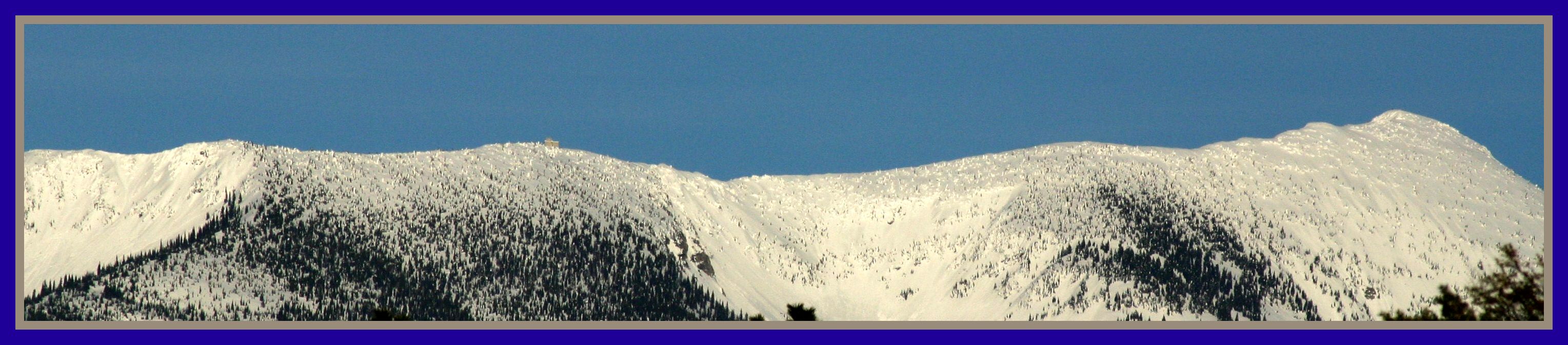
View of The Winter Route from the Flathead Valley Floor.
The Mount Aeneas - Winter Route meets the ridge in the lower left hand corner of the above photo and follows the spur ridge to the upper ridge and then traverses across the ridge to the summit of Mount Aeneas on the far right.The panorama in the route section provides an enlargement of this image.
Getting There:
 Starting up the ridge towards the summit
 Camp Misery Outhouse
 Camp Misery Ranger Shed
The Jewel Basin is part of Montana's rugged Swan Range.
This route is located along the western boundary of Montana’s Jewel Basin Hiking Area, an incredible portion of Montana’s backcountry that has been preserved for future generations by farsighted friends of the wilderness. Please see the Jewel Basin Area page for more details.
The Jewel Basin is open all year but due to massive amounts of snow the roads close sometime in late October to mid November and open again some time between the middle of June and the first week or so of July. During the winter season some backcountry enthusiasts snowmobile or ride 4-wheelers to the trailheads and either snowshoe or backcountry ski into the Jewel Basin.
The Jewel Basin boundary generally follows the ridge line so snowmobile riders can enjoy the basin above Camp Misery. In recent years snowmobilers have illegally been entering the Jewel Basin and a few of them have been caught in avalanches. Backcountry travelers need to be familiar with snow travel and be prepared to deal with possible avalanche conditions. For current Avalanche Advisory.
Red Tape:
 Preping for the Trip
There is little red tape with the exception of a 12-person maximum group size on all trips.
There is a strict "Leave No Trace" policy here as should be expected. During the times when there is no snow hikers are asked to stay on designated trails.
Although most bears are in hibernation this time of year it is possible that one could be out stretching its legs. Follow all guidelines for camping in bear country if you plan to camp as black bear and grizzly bear call this area their home. There are also mountain lions, Canadian Lynx, bobcats and wolverines in this area.
As with all hiking and climbing in Northwestern Montana use caution and practice good manners with the wildlife. Carry your bear deterrent, don’t hike alone and make some noise. For more information please go to the Glacier National Park's website for Bear Information. The U.S. Forest Service also has helpful information on Grizzly Bear Management.
Directions to the Trailhead:
![Meeting the Ridge above Noisy Basin]() Meeting the Ridge above Noisy Creek Basin
Meeting the Ridge above Noisy Creek Basin![View of Noisy Creek Basin]() Noisy Creek Basin
Noisy Creek Basin
Please visit the Camp Misery Trailhead information for directions to the start of the route.
Please remember that the Jewel Basin is CLOSED, therefore OFF LIMITS to motorized vehicles.
Route Directions:
![Heading up the Ridge]() Heading up the ridge
Heading up the ridge![Mount Aeneas Winter Route]() Route Topo
Route Topo![Cornices and the Flathead Valley]() Cornices and the Flathead Valley
Cornices and the Flathead Valley
Total distance to the summit ≅ 2.5 miles.
Total elevation gained ≅ 1,778 feet.
The panoramic image at the bottom of this section shows the described route in better detail. The image shows the route after gaining the spur ridge.
From the Camp Misery Trailhead follow the Jeep Trail to the southeast from the parking area.
There should be a good snowmobile trail to follow as most of the users access the bowl below the boundary this way. Continue on the Jeep Trail until the road takes a very sharp turn and begins it earnest ascent to the ridge on the west of the Noisy Creek Basin. This ridge is on your right as you are traveling up the jeep trail.
At this place there should be an obvious track making a sharp left hand turn (east) which when followed will lead past a set of structures (if they are not all snow-covered). This is the location of the Noisy Basin Snotel station which is run by the National Water and Climate Center, a branch of the NRCS. [See next section for more information on the SNOTEL program.] Continue up hill on a traversing route until an easy way to the ridge on the right is located. There should be some type of trail left by users who have skied or snowshoed there in their efforts to either summit Aeneas or gain more height for some back country skiing.
Although it does to readily appear on the topo map there is a definite spur ridge that makes its way up through the subalpine trees to the summit ridge which is labeled designated as Point 7100 on the route map.
Once the spur ridge is obtained follow the treeline up to the summit ridge near Point 7100. Upon arrival there a sunny day will yield views of the snowcapped mountains of the Flathead Range as well as Glacier National Park.
Once on the ridge traverse below the ridge to avoid cornices to the strange building on the ridge, it is a Microwave Tower. From there Aeneas is about ½ mile away and most of the difficult elevation gain is over. Once again stay well away from the edge and complete an ascending traverse along the wind blown western side of the ridge to the summit of Mount Aeneas.
On a clear day the views into the Hungry Horse drainage as well as Glacier National Park are stunning. The view to the west is not to bad as well since it looks out over the Flathead Valley and Flathead Lake.
To return either retrace your route or descend to the Picnic Basin and follow the Picnic Basin Route to Camp Misery. This route would obviously be exposed to greater danger of avalanches.

![Enlarge]() Mount Aeneas - Winter Route.
Mount Aeneas - Winter Route.
Information on the Snotel Program:
![Snow Ghosts]() Snow Ghosts
Snow Ghosts
The Natural Resources Conservation Service (NRCS) installs, operates, and maintains an extensive, automated system (SNOwpack TELemetry or SNOTEL) designed to collect snow pack and related climatic data in the Western United States and Alaska. In 1935, NRCS, then the Soil Conservation Service, established a formal cooperative Snow Survey and Water Supply Forecasting (SS-WSF) Program to conduct snow surveys and develop accurate and reliable water supply forecasts. The Program operates under technical guidance from the NRCS National Water and Climate Center (NWCC).
With 50-80 percent of the water supply in the West arriving in the form of snow, data on snow pack provide critical information to decision makers and water managers throughout the West. SNOTEL provides a reliable and cost effective means of collecting snow pack and other meteorological data needed to produce
water supply forecasts and support the resource management activities of NRCS and others.
The SS-WSF Program has grown into a network of more than 1,200 manually-measured snow courses and over 750 automated SNOTEL stations in 13 Western States, including Alaska. The Program provides stream flow forecasts for over 740 points in the West. The data, as well as related reports and forecasts, are made available—in near real time for the automated SNOTEL sites—to private industry; to Federal, State, and local government entities; and to private citizens through an extensive Internet delivery system and other distribution channels.
The modern SNOTEL network also provides data for climate studies, air and water quality investigations, climate change, and endangered species habitat analysis. The high-elevation watershed locations, broad coverage, and real time operation of the network provide important data to researchers, river and reservoir managers, emergency managers for natural disasters such as floods and droughts, recreational area managers, and power generation companies.
Source: SNOTEL And Snow Survey & Water Supply Forecasting.
When to Climb and Weather:
As mentioned above the main limitations of this route are the snow and avalanche conditions.

Gear and Camping Information:
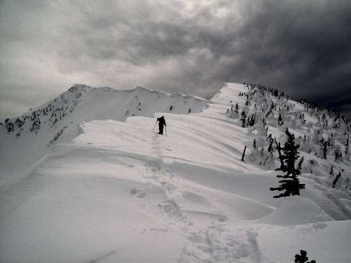
![View of the summit ridge]() View of the summit ridge
View of the summit ridge
Back Country Ski Equipment
Snowshoes
Avalanche Beacon
Avalanche Probe
Shovel
Poles
Water
Camera
GPS (for those who are navigation impaired)
Hiking boots
Sun screen
Winter Camping gear
There are a lot of opportunities to dig snow caves or tent camp if desired.
External Links:
![The Microwave Tower]() Looking down the ridge
Looking down the ridge
Visit Montana
Jewel Basin Official USFS Site
Glacier Avalanche Advisory
 Meeting the Ridge above Noisy Creek Basin
 Noisy Creek Basin
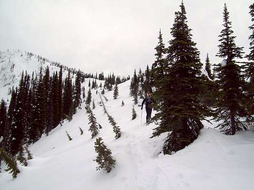 Heading up the ridge
 Route Topo
 Cornices and the Flathead Valley
 |
 Snow Ghosts
Gear and Camping Information:
 View of the summit ridge
Back Country Ski Equipment
Snowshoes
Avalanche Beacon
Avalanche Probe
Shovel
Poles
Water
Camera
GPS (for those who are navigation impaired)
Hiking boots
Sun screen
Winter Camping gear
There are a lot of opportunities to dig snow caves or tent camp if desired.
External Links:
![The Microwave Tower]() Looking down the ridge
Looking down the ridge
Visit Montana
Jewel Basin Official USFS Site
Glacier Avalanche Advisory
 Looking down the ridge