|
|
Mountain/Rock |
|---|---|
|
|
38.85770°N / 120.1692°W |
|
|
9967 ft / 3038 m |
|
|
Overview
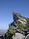
Mount Agassiz is a highpoint of the Crystal Range, a "crest to the west" in Lake Tahoe's Desolation Wilderness. Agassiz is not the highest peak in the Desolation Wilderness, but it is arguably the most spectacular. Perched high above the blue waters of Lake Aloha, the overhanging summit of Mount Agassiz resembles a perfect diving board. The summit views are spectacular as well -- one can survey the entire Desolation Wilderness, see a glimpse of Lake Tahoe, and view the peaks of the Sierra from Donner Pass in the north to Ebbetts Pass in the south. Despite these attractions, Agassiz sees fewer ascents than its more popular neighbors in Desolation. This is likely because (i) it is 16 feet lower than its neighbor to the south, Pyramid Peak; (ii) it is not named on some maps (it is simply Peak 9,967); and (iii) it is quite remote.
Mount Agassiz can be done as an easy overnighter or a more demanding day hike from the Wright's Lake area. Agassiz can also be combined with Pyramid Peak and Mount Price for a high traverse of the southern half of the Crystal Range.
Getting There
From the West. The easiest approach is from the west. Take US 50 to Wrights Lake road (about 6 miles west of Twin Bridges). Follow this road for about 4 miles until you come upon the "Lyons Creek Trailhead". This is the same trailhead used to access the west ridge of Pyramid Peak. Follow the Lyons Creek Trail for about 4.5 miles to a fork. The right hand fork goes to Lake Sylvia and the west ridge of Pyramid. The left hand fork goes to Lyons Lake. The broad ridge separating Lyons Lake and Lake Sylvia is the SW ridge of Agassiz, so you can really pick your poison here. Take the Sylvia fork if you want to climb both Pyramid and Agassiz. Take the Lyons fork if you want to climb Agassiz and neighboring Mt. Price. If Agassiz is your only goal, it is probably easiest gained by climbing NE above Lake Sylvia, following a small creek to an unnamed tarn at 8,740'+, then north to the summit. This route is no harder than class 2 (but with some unstable talus and highly combative flora en route).
From the East. Approaching from the Desolation Valley area is difficult, as the east side of the Crystal Range drops precariously down to Lake Aloha. There are a couple of options, however. The first is what I call the "Overhanging Couloir", a narrow cleft leading from the granite slabs above Lake Aloha to the ridge between Agassiz and Price. This cleft is difficult to see from afar, as it has a huge rock overhanging the entire upper half of the couloir. Gain the granite slabs above Aloha by climbing up from Mosquito Pass towards Mt. Price, and then contouring over to a point below the Agassiz/Price saddle, which is roughly below the base of the coulior. Climb this class 3 couloir to the ridge, then turn left and walk up to the summit block.
The second option is to continue contouring south on the granite slabs towards the bottom of the east face of Agassiz. Aim for the small saddle just east of the summit (seen in this photo). Getting to the saddle likely requires crampons and an ice axe to negotiate the large, steep, semi-permanent snowfield below it, then tough class 3 climbing to get to the saddle. From there, it is a fairly easy walk up to the summit block.
From the South or North. You can also approach the peak from the south or north on a high traverse of the Crystal Range, which would require climbing over Pyramid Peak to the south or Mt. Price to the north, and then continuing along the ridgeline of the Crystal Range. If coming from the south, see the Pyramid Peak page for routes to that summit, then simply head north along the class 2/3 ridge to Mount Agassiz.
Summit Block. The summit block is spectacular and perfectly flat on top, making for a nice vantage point, lunch spot, whatever. It is most easily climbed from the NW side (easy class 3). Lean over the edge and enjoy the exposure.
Red Tape
Permits are required year round in the Desolation Wilderness, one of the most popular "wilderness" areas in the US. There is currently no quota for day use, and permits can be self-issued at most trailheads into the wilderness. There is, however, a rigid quota system for overnight use, a $5/night fee (max $10), strict "zone" restrictions on where you can camp on your first night in the area, limits on group size, etc. etc. Requirements change frequently, so check the USFS Desolation Wilderness page for the latest info.
When To Climb
Agassiz can be climbed anytime of the year, although access to the west side trailheads is snowed in during the winter. Winter access is easiest over Pyramid Peak, or (for experienced skiers/climbers) from Desolation Valley. An overnight trip would be required for all but the strongest skiers.


