
|
|
Mountain/Rock |
|---|---|
|
|
19.3333°S / 32.78330°E |
|
|
9281 ft / 2829 m |
|
|
Overview
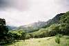
This peak, the highest in Mozambique (and second higest in Zimbabwe), is most easily accessed via Chimanimani National Park, in Zimbabwe. On clear days, it's said you can see all the way out to the Indian Ocean. Chimanimani National Park is usually fairly empty - on many of my trips I was the only person in the park - but the solitude also means you have to be self sufficient. There are a couple different trails up the mountain - it most reminded me of Guadalupe Peak, the highest point in Texas. This is a serious weekend hike more than a technical climb -- a long day for the mountain with some class II sections of trail.
 |  |
Getting There
From the town of Chimanimani (about 3 hours on the bus from Mutare), you can hire a ride. As of January, 2004, there "is a man in Chimanimani village known as Havlock who provides rides into the mountains from town or from Heaven lodge and out again for a cost of about 5 USD and can provide fairly decent maps. He also runs a guiding service. The town is small enough that asking around for Havlock is as good as telephoning (especially considering how seldom the phones work in Chims village)." - (thanks Smalltimeclimber!)
Alternately, you can hitchike and walk the 19 kilometers (it took me about 1.5 hours because of rides) to the park gate. You can pick up wildly inaccurate park maps at the Tourist Information Center in Chimanimani, or get one at the National Geological Survey office in Harare before you go to Chimanimani.
You can also pick up some fruit or other food in Chimanimani town. Once in the park, go straight up and over the pass (Bailey's Folly). When you're at the mountain hut, you can see Mt. Binga - the high point across the valley, South of Skeleton Pass. Ask the ranger at the mountain hut what the best route up is - I went from the North side. When I did the climb, I camped in the valley, and took about 4 hours to the summit.
Smalltimeclimber gives the following beta: "From the hut above the bundi plains is a path that runs towards the neck between Dombe and Binga and then ascends Binga from the left hand side as you face the peak. The path is clear and easily followed. From the hut to the summit of Binga and back should not take more than five hours"
Be sure to get water before going up the mountain - there's none available after the valley.
 |  |
Red Tape
It's in a national park, so there's an entry fee to the park if you go through the main gate. There's also a per night camping fee.
There is a tiered rate structure so that Zimbabweans get a special rate in Zim dollars. Tourists from SADC countries pay 5USD per day (camping/caves) plus 5USD entrance fee and non-SADC tourists pay 10 USD per day (camping/caves) and 10 USD entry fee. Use of the hut incurs an additional cost. Entry fee must be paid in US currency and no change is available.
When To Climb
I did the climb in late September, and it was fantastic. Warm enough that I didn't miss my sleeping bag, but not as hot as November or December would be. I don't think this climb would be fun in the rain.
Other people have done the route almost every time of year. Smalltimeclimber (thanks again!) wrote, "I've climbed it in July and December. December had some rain and thunderstorms but didn't detract from the hiking at all. It is green and water is abundant all year round."
Camping
Camp anywhere. The water is safe to drink out of the streams, and I know of no dangerous animals in the area. Be careful to stay on rocks or the trail if you cross over to Mozambique - there are rumors of land mines, but park rangers that I spoke with have never heard of anyone getting hurt by them, so I don't know how true the rumors are.
There are lots of caves all over, and offer great camping. Smalltimeclimber also discounts the landmine rumor - "I have spent more time on the Mozambican side than on the Zimbabwean side and have never encountered any difficulties with landmines."
Mountain Conditions
With all the political issues that have been happening in Chimaninmani, Heaven lodge has fallen into disrepair. In January 2004, Smalltimeclimber offered this update:
Calling Heaven Lodge is next to useless. They have no telephone and even if they did are not particularly up to date on mountain conditions. There is a park office in Chimanimani village which is in radio contact with base camp and an outward bound school at the base of the mountain which are both better bets. In any event apart from occasional floodings of the bundi there is really nothing in terms of mountain conditions that should detract from your visit.
Supplies are almost non-existent in Chimanimani village. We were unable to by either bread or meat so come well-equipped to the mountains with pasta and breakfast cereals etc. Wood is available for fires but may be damp after rains.
Politics/Health
This is Southern Africa, so although it's not a problem up in the mountains, malaria is a problem sometimes in the lowlands. There's the usual advice about travelling internationally. Also, politics in Zimbabwe have been particularly rough in the past year (2001), and Chimanimani has been a hotbed of activity. Make sure and call ahead before going there.
Chris n Col - Nov 20, 2005 4:31 am - Hasn't voted
Untitled CommentWhilst there are no 'dangerous animals', baboons will relieve you of any food left in unattended packs. I was once robbed of most of my food on one trip when I left a pack to do some flyfishing. Thankfully they decided to let me keep my whisky, a few tins and a packet of spicy atcha rice that they didn't fancy.
Chris n Col - Nov 20, 2005 4:36 am - Hasn't voted
Untitled CommentThere was once an incident prior to 1990 when someone stepped on a landmine near skeleton pass. I have not heard of any other incident since then.