Stegosaurus - Jul 16, 2018 12:05 pm Date Climbed: Jun 23, 2018
Mount Constance South Chute Solo in a Day
Car-camped at the Dosewallips washout Friday 6/22, it rained all night. Left the car at 5 am on the bike, stashed the bike at the first bridge and continued on foot from there. Arrived at the Constance Lake around 8 am. Missed the turn for the climber's trail out of the lake area and ended up bushwacking for about 600 ft of elevation out of one of the campsites until I made my way back to the snow/climber's trail. Visibility was intermittent due to fast-moving clouds lapping over the primary ridge, making route-finding past the top of the South Chute quite difficult at times. South-facing snow was soft when in the sun, but frequent cloud cover kept many of the higher snow slopes frozen - ice axe and crampons on the steeps were essential the day I was up there. Also, as several others have noted, "Olympic 3rd class" is indeed a little stiffer than Colorado 3rd class. Summited around 2pm with spectacular views of Warrior Peak, Inner Constance, and The Brothers summits poking out of a fast-moving sea of clouds. I descended by reversing the South Chute route. Despite having just climbed through the maze of the South Chute with poor visibility, descending via the same route in even poorer intermittent visibility made route-finding difficult again. A partner or more route pictures/notes would help immensely in such conditions. Descended back to the bike by around 7:30pm, and back to the car by 8:00pm for a 15 hour car-to-car. Caught the midnight ferry back to Seattle and home by 1:30am.
This peak is very complex and there are cliff faces everywhere on the upper mountain. We climbed the north chute and finger traverse on the way up and then took the terrible traverse and south chute on the way down. A bad snow patch south of the terrible traverse blocked our path. Rather that climb steep icy snow we free climbed a short pitch of unprotectable mid-5th class rock to get around it. We carried rope, crampons, and axes but didn't use them. This is my new favorite climb in the Olympic Range.
Jake Robinson - Aug 21, 2012 4:26 pm Date Climbed: Aug 20, 2012
FT Bypass
Route is scree until the second notch (when the actual summit block becomes visible), then one must either descend steep snow with rocks at the bottom or descend the moat on the left about 20 feet and scramble up and over the rock rib with some 4th-low 5th class moves. After being belayed down this snow I determined that it would not be safe without a rope as the snow was very icy and difficult even with crampons and an axe. With the amount of snow still up there (probably 10 to 15 feet at this section) it is unlikely this section will melt out at all this year. My partner did the scramble and the rest of the route to the summit block was pretty straightforward (we took the FT Bypass as described on the south chute description on this page). The block itself required a few 4th class rock climbing moves to reach the true summit which we did unroped. On the way back we both scrambled over the rib to get to the notch instead of going up the snow I went down. From here it was awesome scree skiing down to the lake. Biking to the trailhead was a great decision as we made it from the TH to the washout in about 10 minutes.
olymountainman - Aug 12, 2012 6:05 pm Date Climbed: Aug 5, 2012
nice alternative to the dose washout approach
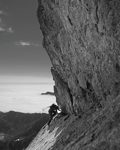
Used the Tunnel Creek trail,ascended the south fork of the creek to an upper basin, took Cunningham pass down to canyon littered with plane wreckage debris from the 1975 crash below the SE face of Constance, took a gnarly scree shute up to meet up with the south chute route just NE of the Cat Ears. Took the Finger Traverse on the ascent, it was no big deal, people exaggerate its difficulty, very exposed, yes, but very short and very easy moves, not worth bringing gear for the few moves. Took the Terrible Traverse on the descent, this on the other hand is a bit sketchy, probably a 45 degree traverse on very hard snow with a nasty drainage below, a short distance to self arrest, used crampons and serious self belaying, still not worth bringing gear for though in my opinion. Tunnel Creek trailhead to base camp in upper basin: 2.5hrs. Base camp to summit: 4.5hrs. Summit to car: 6hrs (including base camp pack up/lunch) Also climbed April Peak the evening before summit sunday :) SUCH a fun climb.
IBentryn - Mar 22, 2012 2:14 pm Date Climbed: Sep 8, 1997
The easy way.
Didn't like the look of the Finger Traverse. Used the variation now described on page 115 of the OMCG. Wonderful dayhike - not sure if that's still possible now that the road is gone?
setrent - Oct 20, 2011 10:33 pm Date Climbed: Jun 5, 2006
Finger Traverse via Avalanche Canyon
Third try at this peak. Don't underestimate the route finding or approach. No need for the fingers on the finger traverse.
Snowslogger - Dec 29, 2009 12:20 am Date Climbed: Aug 27, 2006
Bigger than it's height
Was very happy to finally climb this peak that I'd looked at from the waters of Puget Sound for so long. Rode bikes up the road to the trailhead. Very steep hike up to the lake. A lotta work up, very cool to do both the finger traverse and terrible traverse, as well as some of the top of the west ridge. I think the hike down is worse than up, and overall I was more thrashed by this than many higher mountains.
Stegosaurus - Jul 16, 2018 12:05 pm Date Climbed: Jun 23, 2018
Mount Constance South Chute Solo in a DayCar-camped at the Dosewallips washout Friday 6/22, it rained all night. Left the car at 5 am on the bike, stashed the bike at the first bridge and continued on foot from there. Arrived at the Constance Lake around 8 am. Missed the turn for the climber's trail out of the lake area and ended up bushwacking for about 600 ft of elevation out of one of the campsites until I made my way back to the snow/climber's trail. Visibility was intermittent due to fast-moving clouds lapping over the primary ridge, making route-finding past the top of the South Chute quite difficult at times. South-facing snow was soft when in the sun, but frequent cloud cover kept many of the higher snow slopes frozen - ice axe and crampons on the steeps were essential the day I was up there. Also, as several others have noted, "Olympic 3rd class" is indeed a little stiffer than Colorado 3rd class. Summited around 2pm with spectacular views of Warrior Peak, Inner Constance, and The Brothers summits poking out of a fast-moving sea of clouds. I descended by reversing the South Chute route. Despite having just climbed through the maze of the South Chute with poor visibility, descending via the same route in even poorer intermittent visibility made route-finding difficult again. A partner or more route pictures/notes would help immensely in such conditions. Descended back to the bike by around 7:30pm, and back to the car by 8:00pm for a 15 hour car-to-car. Caught the midnight ferry back to Seattle and home by 1:30am.
seano - Jul 8, 2015 2:15 pm Date Climbed: Jul 4, 2015
Standard routeThe scree was much less awful than I had expected, and the finger traverse was surprisingly fun. Trip report.
cgish88 - Jun 19, 2014 11:21 pm Date Climbed: Jun 18, 2014
Foggy ClimbMade it to the top via the standard route. Was a bit foggy on the way up
Snidely Whiplash - Nov 11, 2013 3:19 pm Date Climbed: Jun 24, 1989
UnsuccessfulTried it twice, don't think I'll be going back. A bit out of my comfort zone.
coonrad - Oct 2, 2012 2:57 pm Date Climbed: Aug 19, 2012
South Chute to Finger TraverseExtremely fun climb on a beautiful peak.
Trip report: here.
gimpilator - Sep 17, 2012 6:10 pm Date Climbed: Sep 16, 2012
Best Climb Of The YearThis peak is very complex and there are cliff faces everywhere on the upper mountain. We climbed the north chute and finger traverse on the way up and then took the terrible traverse and south chute on the way down. A bad snow patch south of the terrible traverse blocked our path. Rather that climb steep icy snow we free climbed a short pitch of unprotectable mid-5th class rock to get around it. We carried rope, crampons, and axes but didn't use them. This is my new favorite climb in the Olympic Range.
Jake Robinson - Aug 21, 2012 4:26 pm Date Climbed: Aug 20, 2012
FT BypassRoute is scree until the second notch (when the actual summit block becomes visible), then one must either descend steep snow with rocks at the bottom or descend the moat on the left about 20 feet and scramble up and over the rock rib with some 4th-low 5th class moves. After being belayed down this snow I determined that it would not be safe without a rope as the snow was very icy and difficult even with crampons and an axe. With the amount of snow still up there (probably 10 to 15 feet at this section) it is unlikely this section will melt out at all this year. My partner did the scramble and the rest of the route to the summit block was pretty straightforward (we took the FT Bypass as described on the south chute description on this page). The block itself required a few 4th class rock climbing moves to reach the true summit which we did unroped. On the way back we both scrambled over the rib to get to the notch instead of going up the snow I went down. From here it was awesome scree skiing down to the lake. Biking to the trailhead was a great decision as we made it from the TH to the washout in about 10 minutes.
olymountainman - Aug 12, 2012 6:05 pm Date Climbed: Aug 5, 2012
nice alternative to the dose washout approachUsed the Tunnel Creek trail,ascended the south fork of the creek to an upper basin, took Cunningham pass down to canyon littered with plane wreckage debris from the 1975 crash below the SE face of Constance, took a gnarly scree shute up to meet up with the south chute route just NE of the Cat Ears. Took the Finger Traverse on the ascent, it was no big deal, people exaggerate its difficulty, very exposed, yes, but very short and very easy moves, not worth bringing gear for the few moves. Took the Terrible Traverse on the descent, this on the other hand is a bit sketchy, probably a 45 degree traverse on very hard snow with a nasty drainage below, a short distance to self arrest, used crampons and serious self belaying, still not worth bringing gear for though in my opinion. Tunnel Creek trailhead to base camp in upper basin: 2.5hrs. Base camp to summit: 4.5hrs. Summit to car: 6hrs (including base camp pack up/lunch) Also climbed April Peak the evening before summit sunday :) SUCH a fun climb.
IBentryn - Mar 22, 2012 2:14 pm Date Climbed: Sep 8, 1997
The easy way.Didn't like the look of the Finger Traverse. Used the variation now described on page 115 of the OMCG. Wonderful dayhike - not sure if that's still possible now that the road is gone?
setrent - Oct 20, 2011 10:33 pm Date Climbed: Jun 5, 2006
Finger Traverse via Avalanche CanyonThird try at this peak. Don't underestimate the route finding or approach. No need for the fingers on the finger traverse.
Snowslogger - Dec 29, 2009 12:20 am Date Climbed: Aug 27, 2006
Bigger than it's heightWas very happy to finally climb this peak that I'd looked at from the waters of Puget Sound for so long. Rode bikes up the road to the trailhead. Very steep hike up to the lake. A lotta work up, very cool to do both the finger traverse and terrible traverse, as well as some of the top of the west ridge. I think the hike down is worse than up, and overall I was more thrashed by this than many higher mountains.