A Great Opportunity
When my wife was facing a challenge of presenting in front of industry experts at the software engineering conference in San Francisco, I thought of taking up a challenge for myself, as I wasn’t too fond of laying around the swimming pool, soaking in the sun, while reading a book or just looking at natural beauties in the pool.
I thought I’d rather explore the sunny California by sweating it out a bit, by hiking in some pristine places, by bonding with Mother Nature, as I don’t often get that opportunity back home.
25 miles NE of San Francisco
My quench for outdoors took me to Mt Diablo, which was an hour’s drive from the place we were staying at. So, a quick fill-up of my hydration pack bladder, and a few bars’ shopping later, I was driving towards having some good time. I decided to access the state park via the north side, through the Mitchell Canyon trailhead. The entry point of the park warrants that you have cash, to be able to pay the park fees, and I was glad that it was just one of those lucky days that I had it. If I remember correctly, a one-day pass was about $6, which I stuffed into the small envelope, and dashed towards the parking, to hit the trail.
At the parking lot there were a few volunteers who had gathered around to clean the area / mountain. The ranger’s station was closed, which wasn’t much of a help, as I wanted to get a map of the area. This made me dependant on the (obscure) print-outs of the area, which the hotel offered to me, free of charge.
The Lone Soul
At the start of the trail, there was a map, which mapped the trail all the way up to Mt. Diablo. I kind of memorized it. I also had a rough sketch of the area, printed off of the internet. My ambitious plans of summiting Diablo, the North Peak, and Mt. Olympia, which form a circular trail, in a day, kind of crashed to the ground, when I learnt that the Diablo trail itself was 11.7 miles one-way.
And, to top it off, it was already around 9 am, which was very late to be on a 23.4 mile hike, let alone a circular trail, which would have been around 35 miles. A family consisting of a dad, with his two daughters was biking down the trail, which kind of assured me of cross-flow of people, while going up. It was later I realized that the biking guys were the only people I would see the entire day (obviously excluding the people who drive up the mountain in their cars).
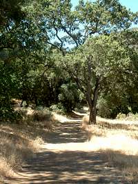
The first leg of the hike was on a wooded trail,
which was amply shaded, and provided enough protection from the blazing sun. The high trees were green all the way and obstructed the sight of mountains standing behind them. I was sure that I would be able to see Diablo as soon as I exit the trees, again about which I was proven wrong. The first campsite on the trail is called deer flat.
I wonder why such a weird name is given to the campsite. If asked a preference, I would rather prefer names of rock climbs (Misunderstanding, Dihedral wall etc.) to campsites, which kind of sound, cool. Deer flat was at a distance of about 3 miles from the base, and by the speed at which I was going, I thought I was making good time. Once I exited the shaded part of the trail, the sun almost attacked me with all the might possible. I understand that the sun in California is not as bad as in my good ol’ Texas, but still, it was pretty bad, pretty much guaranteeing me a small week-long phase of sunburn.
As probably with all trails, this trail also gave me a glimpse of what lied ahead, i.e. a trail, far away, which, at first you don’t believe. You naturally tell yourself – “No, that can’t be the trail.” But, slowly, your self-convincing fact melts in front of you, when you end up walking towards that same point. In a similar fashion, I reached deer flat, which was nothing but a board, which stated the name of the campsite, with all the campsites available for camping.
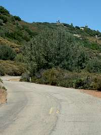
The steep part of the trail, pretty much started after the first campsite.
Also, the constant noise of automobiles reverberates in your ears, making you look out for the road that takes people up the mountain, without burning a single calorie. The trail takes you around the mountain, towards the sky, making you feel, as if you are walking into the sky. The route turns around, and it is here that you see the road,
![First view of the road]()
with an occasional car in sight. You are way above the road, but, soon end up on the same level, as all the cars climb up to your elevation. The point where the trail hits the road is the location of the second campsite, which was also vacant. Except I thought I saw some movement somewhere. And to my surprise, I saw a hyena. It was looking at me, and I was standing still. It suddenly occurred to me that I don’t even have a single knife, not even a pocket knife. I know it wouldn’t have mattered, had something attacked me, but does nothing more than giving you a sort of personal, stupid and unknown gratification, of having a 3-4 inch blade in your hand. I would say, it is better than having nothing. Even when all these thoughts were running through my mind, the hyena, after examining me, just walked into the dry bushes. Now, I had to be aware that something might come by from the bushes, while I was the only lone soul on the trail.
Pacing Down
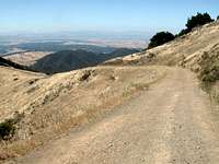
At this time, I lost the trail, and wasted a few minutes looking for it. I did see one going into the bushes, but, after the hyena incident, decided against taking it, walking along the tarred road instead. From this point onwards the summit of Mt. Diablo was in constant view, from the trail. So, the next half hour was along the road, with occasional cars going up and down, with people from the cars peeping out at you,
![Hiking on road]()
as if it’s some alien walking. I guess, it was just my being alone, in that sweltering heat, that everybody was looking at me, otherwise, I am pretty sure Californians are used to seeing lonely souls wandering away in the mountains. After a while, the trail goes from right in front of you, and has a nicely written board, which says, “Summit Trail”. I gladly take the beaten path, which takes me through the lower summit parking lot to the summit. I saw a few ladies wandering on the trail, who had their cars parked on the summit parking lot. So, after a nice, lonely hike, there I was, on the summit of Mt. Diablo. It was a pretty day (is there actually sometime, when California doesn’t have a pretty day?), so I wasn’t too tired, and thoroughly enjoyed the hike. The usual photo session followed, and I started descending, and this is when I received the first call from my wife – “Where are you? And How much longer are you going to take?” Considering the fact that I took around two and a half hours climbing all the way up, I told her an estimate of 2 hours, and then, an hour of driving. Result – she was mad at me, as she was done early, and wanted me to come back immediately.
Pacing down the trail, I clicked as many photos as I could,
so that they could be of use to other people who wanted to climb up Diablo. There were a few enthusiasts I met, on my way down, who wanted to go and camp overnight at Deer flat and carry on with the hike later on. After having given them the usual “good luck”, I almost ran down the mountain, with the not-so-good feeling of not having hiked the circular trail, but a contented feeling of summitting the high point of Contra Costa County, which is shaped like a volcano, and about which, it is said that the view from the top covers 40 counties, and is the world's second most far-ranging view, after Mount Kilimanjaro of Africa! – Pretty cool statistic, isn’t it?


Comments
Post a Comment