
|
|
Mountain/Rock |
|---|---|
|
|
36.50883°N / 118.36287°W |
|
|
Hiking |
|
|
Spring, Summer, Fall |
|
|
12283 ft / 3744 m |
|
|
Overview
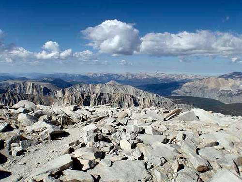 Mt. Guyot from the Summit of Mt. Whitney
The summit at 12,283 feet however affords one an outstanding view of the Sierra’s especially Mt. Whitney’s Western gently rounded summit; a real surprise for first timers expecting to see the same jagged profile as the eastern side of the peak.
Mount Guyot is located in Sequoia National Park and is bounded on North by Guyot Flat, on the east by Guyot Pass, on the south by Rock Creek, and on the west by Kern Canyon.
The lower terrain of Guyot from the Pass is moderately timbered to about 11,000 feet. From this point the slope is a fairly solid mix of sand, gravel, and medium boulders making the ascent basically a steep walk up with little boulder hooping. The descent is a breeze as you slide glide though many areas of the sand, gravel mix.
The summit of Guyot is on the far western end of the Summit Ridgeline. It is necessary to scramble up some fairly large boulders to mount the summit.
Getting There
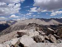 Guyot Summit view to the summit of Mt. Whitney
• Horseshoe Meadows over Cottonwood Pass (11,000 feet)
• Horseshoe Meadows over New Army Pass (12,000 feet)
• Whitney Portal over Trail Crest Pass (13,600 feet)
All driving routes to these trailheads begin out of Lone Pine, California which is located on US Highway 395 in the mid / Southern end of the Owens Valley. Lone Pine boasts of just one traffic signal which is Whitney Portal Road and supports both the Horseshoe Meadows and Whitney Portal trailheads. So in entering Lone Pine from either the South or North, turn west toward the mountains at the stop light. The road begins a rather rapid climb almost immediately through the Movies made famous Alabama Hills. Approximately 2 miles after a small rock mounted Monument on the right recognizing “Movie Flats” you make a right on Horseshoe Meadows Road for Cottonwood / New Army trailheads. Continue on Portal road until it ends to reach for this trailhead and if you are traveling here in midsummer, expect extreme crowds and parking difficulties.
Regarding the road to Horseshoe Meadows, it climbs from 4,000 to 10,000 up a switch backing and at time a one line road to the trailheads. The view on the climb up is magnificent but be careful especially on the decent as guard rails are effectively non-existent.
Both roads close in the fall through early spring so check with the local authorities before heading up. Also getting hit with an early season snowstorm might leave your car stranded for a long winter as the roads are not plowed in the winter.
Trail Overview
• Horseshoe Meadows Trailhead over Cottonwood Pass. 17.5 Miles, 4,830 feet elevation gain, 2,590 feet elevation loss (one way).o Best camp locations: Chicken Springs or Rock Creek, or Guyot Creek.
o Peak could be reached in a two day backpack. With return this would make a long 3 day trip.
• Horseshoe Meadows Trailhead over New Army Pass. 20.5 Miles, 5,300 feet elevation gain, 2,700 feet of elevation loss (one way).
o Best camp locations: Long Lake (below New Army Pass), Soldier Lake, Rock Creek, or Guyot Creek.
o This route would be a 4 day round trip but provides a good opportunity to bag 14Ker Mt, Langley as well as Cirque Peak.
• Whitney Portal Trailhead over Trail Crest Pass. 21 Miles, 6,200 feet elevation gain, 3,610 feet of elevation loss (one way).
o Best camp locations: Outpost camp, Trail Camp, Guitar Lake, and Crabtree Meadows.
o This route would be a 4 day round trip and might be an additional peak to Mt. Whitney.
Multiple Trailhead option as a peak bag trek.
Horseshoe Meadow Trailhead over New Army Pass exiting at Whitney Portal. 44 Miles, 12,195 feet of elevation gain, 13,800 of elevation loss (total loop trek).o This is an excellent trek that allows over a 5 day trek, to pick up numerous outstanding peaks. Realistically over this duration of time, Langley, Cirque, Guyot, Whitney, and Muir could all be climbed.
cab - Aug 26, 2013 12:16 pm - Hasn't voted
Summit LocationThe register, and what appears to be the highpoint, are located on a rock outcropping approximately in the middle of the highest contour on the topo map. The topo map shows an elevation of 3,749m at the far southwest end of the highest contour, but this does not appear to be the highpoint.