Overview
Mount Huethawali (pronounced Wee-the-wali) boasts one of the finest views of any summit in the Grand Canyon National Park. The peak is located just off the South Bass Trail, originally blazed by William Bass in the late 1800s, one of the true pioneers of the Grand Canyon. Over the river are the remnants of a cable system, the first rim to rim route across the canyon, long reclaimed by nature after the construction of the bridges crossing into Phantom Canyon. Given the proximity to the trail, Mount Huethawali, a Native American word for Observation Point, is considered one of the easier Grand Canyon summits, with only a little cross country to reach the base and fairly straightforward and easy class 2-3 slabs to the summit.
It makes for an excellent half day objective or side trip for those hiking in the area of the South Bass Trail, or can be combined with the significantly harder summit of Fiske Butte, Tyndall Dome and Wallace Butte. For those with Grand Canyon Training wheels, Fossil Mountain is another easy summit in the area about 3 miles east.
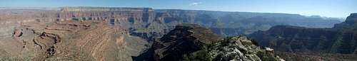
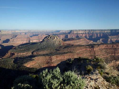
![Summit Panorama]() Summit Panorama
Summit Panorama
Getting There
Getting there is arguably more challenging than the climb itself. From Tusayan, drive north 0.9 miles from the last traffic circle north of town and turn left on to Forest Road 800, which quickly hooks south and becomes Forest Road 328. This is a nice place to camp at large if you're looking to avoid camping fees along the south rim. The first few miles of the road are in pretty good shape and slowly get worse as you pass the turn off for Rowe Well Road, an unrestricted road that connects Grand Canyon Village to the South Bass Trail (and a means to pick up a permit and not have to leave the park to get back to FR 328). Stay on 328 as the path becomes progressively more rutted. If you encounter soft mud that sucks at your tires early- turn back, it gets much, much worse and the road is truly impassable when wet. At a bit over 20 miles you'll cross into Havasupai Land and at ~22 miles, you'll reach a gate at Dodd Tank. This is occasionally staffed by a member of the Havasupai tribe collecting payment to pass through (more on that below). If no one is around, keep driving FR 328 (there is a dirt track which bypasses the gate to the left/south) for another 2 miles to reach Pasture Wash, which is described as a four way intersection, but in reality is two forks in rapid succession. Take the right forks both times and follow the handmade signs for the South Bass Trail. Continuing straight goes to Topocoba Hilltop, currently closed to nontribal members. Beyond Pasture Wash, the road gets even worse with ruts a good 8 inches deep. At this point you'll be heading northeast and will leave the tribal lands, reentering the National Forest. Another 2 miles will bring you to the National Park Boundary, and shortly after you'll pass an old NPS ranger station on the left, which has been out of use for decades. The road gets slightly better back on NPS land and you reach the South Bass trailhead about 3 miles from the NPS boundary. If you're looking to check out the old Fire Lookout on Signal Hill or hike Fossil Mountain, the turn off is the last sharp right turn before the trailhead. I was able to negotiate the route with a Subaru Forester, but I needed every millimeter of clearance, and most of the other cars I saw in the area were lifted. Clearance is more important than AWD/4WD, although even the toughest car would struggle if the road was mud.
Route
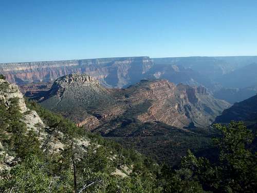
![Mount Huethawali from near the trailhead.]() Mount Huethawali from near the trailhead.
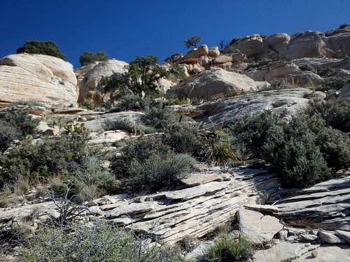
Mount Huethawali from near the trailhead.![The class 2 slabs]() The class 2 slabs
The class 2 slabsFrom the South Bass Trailhead, hike about 2 miles down switchbacks through the Coconino to reach the Darwin Plateau. Mount Huethawali will be in sight the entire time. Once on the plateau, you'll need to continue slightly east to avoid some of the Redwall cliffs formed by a shallow drainage off the plateau dropping to the west. Leave the trail once you spot a good line through the Redwall (shouldn't be more than easy class 2) and begin an ascending traverse back west, aiming for Huethawali's Southwest slopes. While the majority of the mountain has some good sized cliffs, the SW slopes are much more forgiving and have significantly less rock and cliff than the rest of the mountain. Reaching the SW corner, you may pick up a cairn or two as you ascend- but don't overthink it, there are a number of options from easy class 2 to difficult class 3, all funneling to the summit ridgeline. Reaching the summit ridge, there are some false summit blocks that can be avoided by skirting to the north before climbing a few small tiers of coarse limestone to reach the summit cairn.
It is worth mentioning that there are some serious cliffs to the north, and it is not advisable to drop directly off the north if combining with Fiske Butte, Wallace Butte or Vulcan's Throne. In the end it's much faster to descend the way you came, even with a rope.
Red Tape
This hike is entirely on NPS land, and technically a permit is required for any overnight use in the area of South Bass Trail including the trailhead, which has several nice campsites. That being said, this area is not frequently patrolled, and you could probably get away with camping there and not picking up a permit first- up to you if you'd like to risk it.
Crossing through the Havasupai Land is another issue. While most information online and even a sign at the gate suggests a $25 fee to pass through (which to be fair, is cheaper than what the NPS charges for entrance these days), based my most recent interaction with a tribal member at Dodd Tank, the Havasupai now expect you to call in advance to make a reservation to pass through, and seem to charge a similar fee structure as Havasu Falls- per hiker/ per day, even if you're on NPS land the entire time. I can not find this information anywhere else, and it may have been a misinformed tribe member, but something to be aware of if you're planning a trip to this part of the Grand Canyon.
When to Climb
As with most hiking in Arizona, Fall and Spring are the best. Summer can be brutally hot, although the entire hike is above 5500'. No water sources, including the rim. Winter can bring serious ice on the upper portions of the South Bass Trail, although microspikes should work fine in an average year. A good winter storm can easily make the road impassable with mud, so it might be worth waiting for the roads to dry out after a major storm rolls in. This area of the north rim can be popular with Elk hunting in the fall, so it may be something to bear in mind if you don't like the sound of shotguns ringing when you're exploring the canyon.
Camping
This entire area of the canyon is considered at-large backcountry camping including the trailhead, and permits are required by the NPS. There are also some really nice spots along the rim near Signal Hill, heading towards Havasupai Point. The closest water is the Colorado River, so bring more than you think you'll need, car trouble would not be unheard of given the condition of the roads.
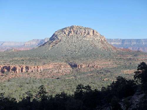
![Mount Huethawali]() Mount Huethawali
Mount Huethawali
![Sunrise on Huethawali from Fossil Mt.]() Sunrise on Huethawali from Fossil Mt.
Sunrise on Huethawali from Fossil Mt.