
-
 8553 Hits
-
 81.52% Score
-
 14 Votes
|
|
Mountain/Rock |
|---|---|
|
|
43.06593°N / 109.62364°W |
|
|
Hiking, Scrambling |
|
|
Spring, Summer, Fall |
|
|
12342 ft / 3762 m |
|
|
Overview
Mount Lester is a gently rising peak north of Lester Pass off the highline trail of the Wind River range. It sits above 12,000 feet, a few miles east of Seneca Lake, and is viewable along the way to Indian Pass Trail, and the renowned Titcomb Basin Trail. Though not a Titcomb Basin 13er, Mount Lester offers a direct view of the classic range to the north on a clear day. It is also off the beaten path of those approaching Titcomb Basin, allowing for a more secluded detour. If entering the range from Elkhart Park, it can be a way to more gently approach the Wind River range. You may consider it if you want to enjoy a short trip and short summit of a Wind River peak with only spending 1 overnight stay, compared to other 13ers of the range which, for some, may require more nights.
Getting There
If approaching from the west, Seneca Lake Trail, begin your trek on the Pole Creek Trail, that starts at the Elkhart Park Trailhead. I would plan to get there by starting at Pinedale Wyoming. Turn off Hwy 191 (Main drag of Pinedale) to the north onto Fremont Lake Road. Continue on that road for a few miles, it will turn into Skyline Dr and follow it to Elkart Park, past the guard station where there is a large trailhead parking lot. Road distance from Hwy 191 should be approx. 14-15 miles. At the trailhead there are vault toilets, a trail register, and sometimes a running water spout, though I'm not sure it is potable...
Route
Perhaps the most moderate approach to the summit involves a mixed route from Lester Pass. It starts as a gently sloping hike up the south ridge, turning into a class 3 scramble. Start this approach from the saddle of Lester Pass and move northward off the trail hugging the east side of the ridge.
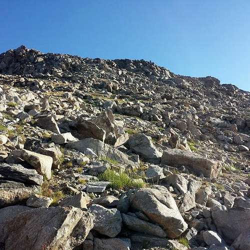 You will roll over a few hilltops until you reach a final crest that drops into the last 1/4 mile of the approach.
 Just before you reach the crest you may see an iron plate memorial to "Mike" with a date range of 1964-1982. If anyone knows more about this memorial I am more than happy to dedicate some space on this page for it.
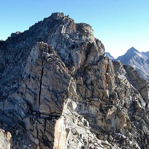 Spires jutting up at the ridgeline crest.
Once at the crest you may more than likely need to drop to the west a hundred vertical feet or so to keep moving in a class 2 and some class 3 sections with a few scrambling maneuvers to keep pushing north, hugging the west side of the ridge as high as you can. There may be climbing sections higher that some may find comfortable with a rope and protection, depending on your level of technicality and speed along that sort of terrain. In either case you will eventually come to a rock chute that leads to the summit. There are loose sections of rock at the time of this post that may start short runs of rock fall. For this final crux I would reccomend wearing a helmet, if not already after starting off from the crest.
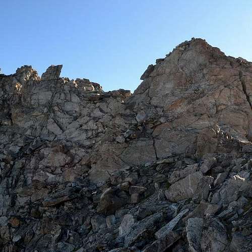 Traversing the upper west side of the south ridge.
Once at this rock chute scramlbe up a hundred feet or so, using frequent hand and foot holds until you reach the summit. From the summit you can take in views of Titcomb Basin, Island Lake and the waterfalls pouring into it, Bald Mountain Basin to the south, the emerald green tarn directly lower to the east, and Elephant Head directly north. Descend the same way you approached.
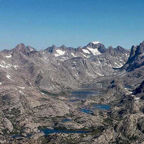 View into Titcomb Basin from the summit.
Red Tape
As of March 1 2016 The Bridger-Teton National Forest ordered an expanded food storage boundary which includes this location. You will be required to carry a bear resistant container, or hang or store your food according to best practices. I would also suggest carrying bear spray. See also the following links:
https://www.fs.usda.gov/Internet/FSE_DOCUMENTS/fseprd506953.pdf
https://www.fs.usda.gov/detailfull/btnf/home/?cid=fsbdev3_063588&width=full
Otherwise follow updated fire use restrictions, practice leave no trace practices, camping 200 feet from water sources.
When to Climb
Though this climb is doable year round, I would suggest climbing from early summer to late fall to have the easiest approaches. Snowbanks are known to cover this trail well into June, making the approach difficult for some without the right equipment. I would love to hear reports of spring or winter ascents! But understand that you will need to prepare beyond the level I am willing to.
Camping
I found the best water sources to be available after you pass Photographer's point. After that you can find multiple accomodating campsites from Hobbs Lake, Seneca Lake and others. I would suggest pushing all the way into the basin east of Seneca Lake, just west of the west face of Mount Lester, right after the trail junction splits off to Indian Pass Trail.
hgrapid - Sep 8, 2017 3:28 pm - Voted 10/10
CoordinatesNice page! Just a note. Coordinates are off by about a mile. Try 43.065926, -109.623644
iamcalypso - Sep 8, 2017 4:00 pm - Hasn't voted
Re: CoordinatesUpdated, thanks for double checking that!