
-
 13762 Hits
-
 83.69% Score
-
 17 Votes
|
|
Route |
|---|---|
|
|
34.26904°N / 118.23896°W |
|
|
Hiking |
|
|
Spring, Summer, Fall, Winter |
|
|
Half a day |
|
|
Trail |
|
|
Overview
Mount Lukens, also called Sister Elsie Peak, towers above the foothill communities of La Crescenta and Tujunga in the San Gabriel Valley. It lies within city limits and is not surprisingly the high point of Los Angeles. There are many ways to get to the summit; most of them involve walking along monotonous fire roads for miles. The quickest and most beautiful is the ascent from the north via the Stone Canyon Trail. After crossing the Big Tujunga Creek, which sometimes may be difficult or even impossible, this trail relentlessly climbs up the north side of Mount Lukens with an average elevation gain of about 800-900 feet per mile. It is also mostly in the sun with very little shady areas so plan accordingly. Because of its proximity to the city and its nice elevation gain many people use this trail as a conditioning hike for bigger and more strenuous backpacking adventures. The summit is plastered with radio antennas and towers but nevertheless provides stunning views over nearby peaks of the San Gabriel Front Range and down to the City of Angels. There is another description of the trail here (by Steve Larson), which has initially been overlooked by me. However, since it does not contain any pictures and has not been updated for over two years, I've decided to keep this new and illustrated page and honorably mention the "old" page.
Route Description

From the trailhead at the eastern end of the Wildwood picnic area (1,800’) a post marks the beginning of the Stone Canyon Trail. Go down to the Big Tujunga Creek and find a spot to cross the creek. Some reports say that after the snowmelt and after heavy rain Big Tujunga Creek is impossible to cross in that area. Some tree logs usually aid to get over the creek. Once on the south side of Big Tujunga turn immediately to your left (if you crossed the creek near the Wildwood picnic area), stay near the river bed and scramble over loose rocks a few hundred feet east. Don’t climb the south bank of Big Tujunga Creek and scramble up Stone Canyon to find the trail. After a few hundred feet you will see a little rest area on your right and the start of the Stone Canyon trail leading directly south under some wooden towers with power lines. Note the trail is on the east bank of Stone Canyon and not visible from the canyon bottom. If you scramble up Stone Canyon you have to climb up the east bank to get on the trail.

The trail itself is well maintained here and leads straight south up the eastern bank of Stone Canyon. In spring there are plenty of yuccas in full bloom. The trail then leaves Stone Canyon and turns left and up around the first hilly prominence to an unnamed canyon east of Stone Canyon. From here you have a great view backwards towards the Stonyvale picnic area and community. The trail relentlessly climbs uphill on the western side of the unnamed canyon. There is no single level portion to recover. At some spots the trail is pretty overgrown and blocked by toppled trees and bushes. Be careful with plenty of Poison Ivy on both sides of the sometimes narrow trail.

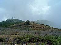
After about 2 miles (at about 3,600 feet elevation), the trail turns west and then south again and after some switchbacks you reach an open area with the trail junction leading down Haines Canyon. From here the trail leads further south/southeast and after some seriously steep passages (especially after already about 3,000 feet of elevation gain) climbs up to the summit ridge of Mount Lukens. This portion is well maintained and flanked on both sides with beautiful manzanitas. At the ridge you have marvelous views over the foothill communities, the Verdugo Mountains, and the LA basin in general. The trail leads east on the ridge and meets the Mount Lukens fire road at 4,930’. Following the fire road you reach the summit area covered with radio antennas. The little summit cairn is at the western end of the installments and represents the highpoint at 5,074’. Enjoy the views, regain your strength, and head back the same way if you did not arrange a car shuttle. Remember that the way back is all downhill and allows for quite some fun trail-running.
There are many alternatives from the summit area if you like walking on fire roads. To the east after about 8 miles the fire roads eventually leads to the Los Angeles Crest Highway or you can take a junction down to Grizzly Flat and reach eventually the Grizzly Flat Trail to Stonyvale. The fire road to the west takes you down towards Haines Canyon and eventually to Big Tujunga Canyon Road.
The roundtrip from the Wildwood picnic area to Mount Lukens via Stone Canyon trail and back covers about 8 miles with an elevation gain of a little bit more than 3,200 feet.