
|
|
Mountain/Rock |
|---|---|
|
|
34.26890°N / 118.238°W |
|
|
Los Angeles |
|
|
Hiking, Mixed, Scrambling |
|
|
Spring, Fall, Winter |
|
|
5074 ft / 1547 m |
|
|
Overview
Mount Lukens stands majestically above the Crescenta Valley as the western most peak of the San Gabriel Mountains front range and is the highest point within Los Angeles city limits. It's western flank drops over 3,000 feet affording terrific views of the San Fernando Valley to the southwest and the Verdugo Mountains and the Los Angeles Basin to the south. On exceptional days both the south and west facing beaches can be seen. When looking north you see a large portion of the Tujunga Canyon watershed with views of Condor Peak, Fox Mountain # 2, Josephine Peak, Strawberry Peak and more.
Named for Theodore Parker Lukens, who was a successful Pasadena businessman, land owner and two time mayor. But his real passion lay in reforestation and conservation. Early on he recognized the devastation of mining and wildfires in the San Gabriel Mountains and the ensuing erosion. While working for the US Forestry Service he began an ambitious plan to reforest the mountains and established the Henniger Flats Nursery in 1903.

John Muir 1895

John Muir & Theodore Lukens
In the summer of 1895 Lukens packed up and headed to Yosemite to catch up with and meet famed Naturalist John Muir. Together they roamed the Hetch Hetchy Valley studying the soil and native plant species. Later in life Muir convinced Lukens to join the Sierra Club Publications committee and keep pressure on elected officials regarding conservation issues. Click this link to read a more in-depth Biography of his life.
But Mount Lukens cannot escape controversy and is beset with a naming conflict. An 1875 survey notes the name as Sister Else Peak (later known as Sister Elsie Peak)after a Roman Catholic Nun who died during a small pox outbreak caring for the sick. The Sierra Club and Catholic Church have summarized what little information is known about her here. The 1925 USFS survey changed the name to Mount Lukens with a Sister Elsie subtitle. Survey maps for the period only serve to confuse the issue. The 1933 survey marker states the peak name as Sister Elsie.

1933 Mount Lukens (Sister Elsie) Survey Mark
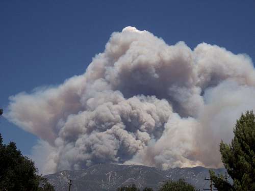
2009 The Station Fire approaches the summit plateau of Mount Lukens
Mount Lukens is primarily covered in dense Chapparal consisting of Manzanita, Buckthorn, Scrub Oak, Yucca and other California Native plant species. Historically its flanks have been cleansed by wildfire originating in the backcountry. But with the encroachment of civilization many fires including two in the 1870's, the well-known Pickens Canyon Fire in November 1933 and Station Fire in August 2009 have resulted in near complete burns. Chapparal is well adapted to wildfires and full recovery can occur in as little as 10 years. Already two years since the Station fire and new growth is well established on many of the mountain slopes. This of course does not diminish the ongoing risk of significant mud and debris flows for the next several rain seasons.
Sadly because of the prominence of the peak and its proximity to the major urban area of Los Angeles, its summit plateau is dotted with radio and cellular transmission towers. While not the most aesthetic summit features this should not detract from visiting this peak. The views in most every direction are pleasing in all seasons. This peak offers great short distance ascents where you can get nearly 3,000 feet of elevation gain in a few miles. Perfect for keeping your conditioning for more lofty goals. CURRENT SUMMIT WEATHER CONDITIONS courtesy of the tower operators can be found here.
Getting There
Mount Lukens is easily accessed from the North, West and South. It stands alone as the final western peak of the San Gabriel Mountains Front Range.
ACCESS FROM THE SOUTH

Deukmejian Wilderness Park - Dunsmore Canyon Trail Map
The best access from the south is from the City of Glendale Deukmejian Wilderness Park in Dunsmore Canyon. From here you can reach the summit from both the Rim-of-the-Valley Trail or the Crescenta View Trail. Both trails leave park boundaries.
Directions
From the Foothill 210 Freeway in the city of La Crescenta exit Pennsylvania Avenue heading north up the hill approximately 4/10th's of a mile. Turn left on Foothill Boulevard and go 3/10th's of a mile turning right onto and up New York Avenue. Head north for one mile until it ends and turns left onto Markridge Avenue. Immediately start looking for a right turn into Deukmejian Wilderness Park. The Park address is 3429 Markridge Road. Follow the entrance road to the parking area at the top.
Parking is free and park hours are limited from 7:00 a.m. to Sunset.
ACCESS FROM THE NORTH

Mt. Lukens apenglow
The Stone Canyon Trail is the only established trail form the north. Access to this trailhead can be challenging depending on the runoff of the Big Tujunga Creek and a trailhead that requires a little scouting. The Station Fire has had its impact. The trail is overgrown and some ravine washouts require extra attention to cross.
Directions
To access the trailhead take Foothill Boulevard in Sunland turning north onto Mount Gleason Road. Turn right onto Big Tujunga Canyon Road and drive north about 5 miles to the Wildwood Picnic Sign. Take right onto Doske Road which becomes Stonyvale Road to the picnic area and look for a sign indicating the “Stone Canyon Trail”. Parking requires an Adventure Pass.
ACCESS FROM THE WEST

Nearing the summit towers
The Haines Canyon Trail is the most popular access point from Tujunga. It originates in a residential neighborhood and follows a well maintained fire road. The road is very scenic with many fine view points.
Directions
To access the trailhead take Foothill Boulevard in Tujunga turning north onto Haines Canyon Avenue. Proceed north turning right onto Day Ave. and turning left quickly back onto Haines Canyon Avenue. As you proceed you will sense the road is ending soon. Pick a spot on the right side of the road just below the last few houses. If you have reached the flood control basin you have gone to far. Avoid parking just below the catch basin. Be respectful that you are parking in a quiet neighborhood.
OTHER ROUTES
There are many other trailheads for variation. Check this page for a listing of the others.
Red Tape
There are no use fees or permits required to hike the mountain.
Parking
North side - You must have a National Forest Adventure Pass for any parked vehicle at the trailhead. Fees are $5.00 a day or $30.00 for an annual pass. They can be purchased at any ranger station or most sporting goods stores.
Adventure pass
South side - Parking at the Deukmejian Wilderness Park is free. Park hours are limited from 7:00 a.m. to Sunset.
When To Climb
This peak can be climbed year round. As a reminder the valley floor temperatures can be very hot in comparison to the summit so be mindful of the season. Any midday attempts during the summer will have significant sun exposure. There are no water sources on this trail or at the summit so bring plenty and stay well hydrated.
Camping
None Allowed.