
-
 15652 Hits
-
 91.14% Score
-
 34 Votes
|
|
Mountain/Rock |
|---|---|
|
|
42.85869°N / 110.59124°W |
|
|
Hiking, Scrambling |
|
|
Summer |
|
|
10780 ft / 3286 m |
|
|

Overview
With four major summits and a few more minor ones, Mount McDougal is a massive and major peak in the Wyoming Range; north to south, the entire formation is around nine miles in length. The good news for peakbaggers is that the highest summit is the one closest to the trailhead. The better news for mountaineers in general is that it is an uncomplicated traverse across all four major summits, and if you’re up for a little adventure, it’s possible to scramble down to a trail from the last summit, enabling a loop-style outing that leaves you retracing your steps for less than a quarter-mile.
Views are rewarding. They include the major summits of the Wyoming Range, including the classic view of Triple Peak to the south; the length of the Salt River Range; the Gros Ventre Range; the Tetons; and the Wind River Range, including Gannett Peak, Wyoming's highest.
About the Name
Duncan MacDougall, a fur trader in the early 1800’s, is the namesake of the peak. No one seems to know why. MacDougall never climbed the peak and is believed never to have even visited the Wyoming Range at all. Robert Stuart, an associate of MacDougall’s for whom a peak in the Salt River Range is named, did travel along the nearby Greys River, but that appears to be the only known connection between MacDougall and the mountain, gap, and stream that bear his name.
Adding to the strangeness of honoring MacDougall in such a way are the facts that he was apparently not well-liked by many who knew him and that historians have not discovered much about him to recommend him well. MacDougall was known to have sold out his investment partner by selling out his partner’s property on the cheap and pocketing the proceeds, and he used a bottle that he claimed contained smallpox to threaten Indian chiefs into doing what he wanted.
The source for the information about MacDougall is Thomas Turiano’s Select Peaks of Greater Yellowstone.
Route Information
The route Turiano describes is a Class 1 outing starting from the parking area at McDougal Gap. Hike north on the Wyoming Range National Recreation Trail, here a closed dirt road, for a mile to Kleinstick Mine and then ascend over 2000’ up grassy slopes to the summit. This is easy but very steep hiking, as it is only a mile from the trail to the summit.
I did not use Turiano’s route and cannot say much more about it. On my return, I could see the slopes he refers to and could tell the way up with no trouble. I should add that I saw very little resembling an old mine except for what might have been a tailings pile. However, my return involved some miles of cross-country hiking that put me back on the trail in the vicinity of the mine, and it is possible that I reached the trail a little south of the principal ruins and thus did not see them.
My route up was one I knew of from another SP member. It interested me because it was both more direct and more challenging. The route is obvious to spot from the trailhead, and pictures on this page show the route, including the trailhead view.
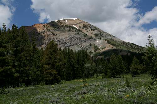 Trailhead view
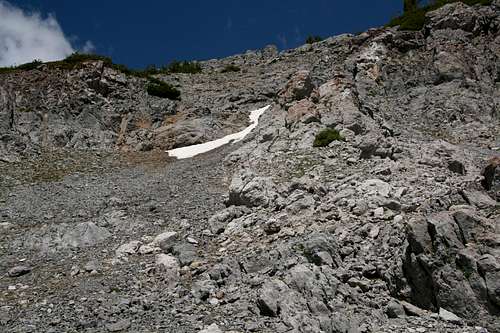
From the trailhead, I walked the trail not even a quarter-mile, and where the trail bent right to go into the woods, I left the trail and started ascending through the forest to the left, eventually gaining a ridge above a deepening drainage on the south face of the mountain. I followed that ridge to the top, sometimes leaving it for easier or more interesting terrain but still following its course. At the top, I climbed a short headwall of snow that in many summers may not be there much past June.
My friend had mentioned a spot of easy Class 4 climbing to avoid some snow and a cliff band near the top, but I never encountered anything close to Class 4. I am not contradicting his account; his is a word I accept without question when it comes to mountain routes. When I studied a picture showing his route, I noticed that I more or less followed his route but deviated a bit the higher I got. The hardest climbing I ever encountered was some Class 3 in a couple places. Still, it was nice to go a different way than that described in the book.
 |
 |
 |
The summit did not have a cairn or register that I could see, but what seemed to be the highpoint was covered in snow, so a cairn or register could have been buried. But the Wyoming Range probably sees the least amount of mountaineering activity of all the major ranges in the Greater Yellowstone Ecosystem, and it would not be surprising if even a named peak with Class 1 access had a clean summit. I say this not because I think someone should go build a cairn or place a register but rather because I love peaks that lack them.
 Point 10,623 |
 |
I did not make a GPS track, but the distance to the summit is about two miles, with nearly 2400’ of elevation gain. Since Turiano lists his route as two miles and mine was more direct, mine is really probably more like 1.5-1.7 mi, assuming Turiano’s distance is accurate.
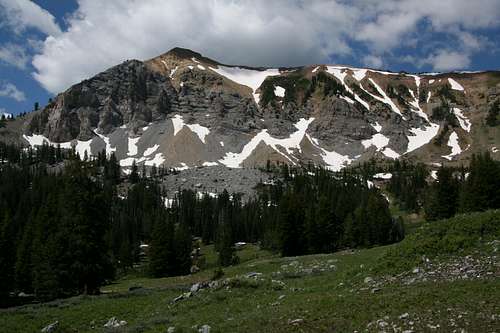
From the summit, go back the way you came, descend via Turiano’s route, or continue north over the other three major summits on the peak, which are, in order, Point 10,682, Point 10,642, and Point 10,742. A game or climber’s trail leads almost all the way along the crest of the ridge, disappearing occasionally in grass, dirt, or snow but always reappearing quickly. This traverse is approximately four miles if you estimate it on the map, but it only took me about an hour to do, and I am guessing the distance is closer to three miles. But for planning purposes, it’s better to assume the longer distance.
 |
 |
 |
I highly recommend that third option, and from that last summit, I also recommend descending east via the steep, rocky slopes there. It is easy to see the Wyoming Range National Recreation Trail in the meadows below, and careful route finding will make this descent, not an easy one on the knees, no worse than Class 3. The map suggests there are cliff bands to negotiate, and there are, but I repeat that I was able to get through with no worse than Class 3 climbing (which was good since downclimbing Class 4 and 5 terrain usually sucks). The straight-line distance on this descent can be as little as half a mile, but you should expect the real distance to be up to twice that. The very steep portion of the descent covers about 1000’, and the last 400’ or so are much gentler.
 Descent
The return hiking distance will vary according to where exactly you reach the trail, but it will be around three miles.
Note: I made a time-consuming and energy-burning mistake on the return hike. Because I initially only planned to go up to the main summit, I had a topo map covering what I needed, not the whole mountain and the vicinity. Therefore, when the trail crossed a stream and forked at about 9250’, almost due east of the saddle between Points 10,742 and 10,642, I took the left fork. This was because it looked better-worn and because from up high, I had not seen a trail in the area that right fork seemed to be going.
At first, the trail worked well, but it soon started trending more east then south, and I was getting a little doubtful about my choice. Eventually, the trail disappeared next to a foul-looking pool. I had already gone far enough that I did not want to turn back, so I went cross-country southwest until I regained the right trail near the Kleinstick Mine. En route, I had to cross several steep drainages.
Don’t make the same mistake I did. Take the right fork. Better yet, have the right maps; the USGS quads Lookout Mountain and Triple Peak show all of the route.
Maps
 |
 |
 |
Getting There
The route begins from the trailhead parking area at McDougal Gap. You can approach from the east or west, but it is a long drive either way, and most of it is on unpaved roads (though suitable for most passenger cars in dry conditions).
From the east: Three miles south of Daniel Junction, leave U.S. 189 and turn onto Cottonwood-Ryegrass Road (#117), heading west. After about 14 miles and passing several minor roads, turn right at Ryegrass Junction. The road soon crosses into Bridger-Teton National Forest. Turiano says it is 15 miles from Ryegrass Junction to McDougal Gap, but I got 17. The parking area is large and obvious.
From the west: From Alpine, drive south on beautiful Greys River Road to a junction with McDougal Gap Road. The sign at the junction says it is 35 miles to Alpine, but the junction is at MP 32. From the junction, it is almost nine miles to McDougal Gap.
There are other approaches as well, all via Tri Basin Divide, from Big Piney, La Barge, and U.S. 89. Tri Basin Divide is 26 road miles south of McDougal Gap Road, and approaches via it can be up to almost 80 miles.
Red Tape and Camping
Nothing special-- read the postings at the trailhead sign.
There are campgrounds along Greys River Road and McDougal Gap Road; I honestly did not pay attention to which ones were how close. Dispersed camping is allowed, and good sites are virtually unlimited.