Mount Shasta - Casaval Ridge

Page Type Page Type: Trip Report
Additional Information GPX File: Download GPX » View Route on Map
Date Date Climbed/Hiked: May 4, 2011
Activities Activities: Mountaineering
Seasons Season: Spring

Intro

This was my third ascent of Mt. Shasta with my climbing partner, Sid. Our first ascent was via the Bolam Glacier while attending the Marine Corps Mountain Warfare School 23 years ago. After a long hiatus from the mountain, we returned last year and climbed it via Green Butte Ridge. This year we decided to try the Casaval Ridge. We knew it was a winter or early spring route and leapt when we saw what looked to be a good weather window that aligned with work demands. As it turns out we hit it just right. With just a couple days notice, Sid drove south from Oregon and I drove north from the San Francisco bay area after work. We met in Mount Shasta City on Monday night and stayed in town, planning on a good night sleep, a hearty breakfast and starting out first thing in the morning. When we stopped by the ranger station in town, we got a very helpful briefing on the expected weather and route.

Day 1

We started from the Bunny Flats trailhead at around 11am and headed to the Sierra Club Hut, where we chatted with a few hikers before heading up the toe towards the rocky ridge. As was pointed out in the route description posted by Diggler and Pellucid Wombat, this initial step is longer than it looks, with a gain of 1,500 feet. It is a long hike up the slope to the initial ridge line. We used snowshoes and moved at a reasonable pace. We acquired the ridge in the mid
Mount Shasta - Casaval Ridge trip
afternoon. We had been debating about where to camp. We knew some people camped at this point of the ridge at 9800 feet. Others continue moving up and bivouac higher at around 10,200 feet. We were trying to figure out what would work best with our descent from the summit. We saw that some people camp higher and after reaching the summit descend the west face and traverse to get back to their campsite. We decided we could descend by way of Avalanche Gulch and traverse back to our campsite on the lower ridgeline. The advantage lies in not having to carry full packs the additional 400 feet while still having a very nice campsite with great views. It also took advantage of the hard work of some previous climbers who had dug well protected sites for their tents at 9,800.
Mount Shasta - Casaval Ridge trip
After deciding to stay at 9,800 feet, we set up camp, melted snow, took in the views and had dinner. We decided to plan on an early morning start and tried to get some sleep. However, neither one of us could sleep and by 12:30 AM were up making coffee, getting gear ready and having another bite to eat.

Day 2

Mount Shasta - Casaval Ridge trip
By 1:45 AM we're heading up to acquire the higher ridgeline. Winds were very mild. Once we acquired the ridge, the initial movement was over easy ground on top of the ridge. Soon though, we were being pushed down on the west side of the ridge by the gendarmes and other rock formations. We had read all about the exposed nature of this route and have no doubt that it is. The downside of the alpine start is we couldn't see much beyond the stars above and what was in the cone of light from our headlamps on the ridge. We rightly surmised that we better be careful because the slope below was steep, though we couldn't see much of it.

We have heard varying accounts of the steepness of this route. The ranger had told us the steepest portion is 42 degrees, and is on a section called the wineglass. We know that visually assessing slope angle is very subject to personal perspective, but at around 11,600 feet we were forced to move perpendicularly up the ridge (rather than traverse) and it certainly seemed steeper than 42 degrees.
Mount Shasta - Casaval Ridge trip
We were frontpointing and making full use of our ice axe to gain the ground. Luckily this was a fairly short section and it was too dark to see what we were climbing over - even still it had a pretty high pucker factor. After this we were able to continue our traverse along the ridgeline, generally staying as high on it as the gendarmes allowed.
Mount Shasta - Casaval Ridge
We eventually reached the wineglass, though there were two formations that seemed to fit the description given at the ranger station. I took one and Sid took the other. Luckily we ended up at the same spot at the top. From there we moved up to the first catwalk and started moving along it. We came to a place where the snow had built up significantly on the catwalk. Movement beyond this point required traversing a very narrow, sloped ledge. We felt it was too dicey given the exposure below it.
Mount Shasta - Casaval Ridge trip
The build up of snow before the dicey ledge, however, had created an escape route which allowed us to move towards the second catwalk without backtracking which was a much more attractive route, while still offering the thrill of some exposure. Following the catwalk we moved up and towards Misery Hill, the summit plateau and eventually the summit at around 10AM. The wind had picked up but was still not too bad. However, we did keep a low profile for our obligatory summit photos.
Mount Shasta - Casaval Ridge trip


To move back to our camp we entered avalanche gulch in the vicinity of Thumb Rock and Konwakiton Glacier. We traversed to the southwest, achieving a glide path straight into the ridge at 9,800 feet and our campsite. We did not have to do any additional uphill climbing to reacquire the ridge. By this time the snow was getting soft and wet. Our crampons were beginning to look like 70's era platform shoes with the thick layer of snow adhering to the bottom. I eventually took off my crampons and plunge stepped back to our campsite. After a little food, a lot of rehydration and some rest, we packed up and continued down the mountain, post-holing most of the way until we got down to the Sierra Club Hut and put back on our snow shoes.

We found the Casaval Ridge very rewarding. It lived up to all the positive route descriptions we had read. We were lucky and hit the weather window just right and had a memorable, exciting climb.


Comments

Post a Comment
Viewing: 1-20 of 32
12
bajaandy

bajaandy - May 15, 2011 10:50 am - Voted 10/10

Nice!

Great trip report. Sounds like you had an excellent climb.

jpsmyth

jpsmyth - May 15, 2011 12:07 pm - Hasn't voted

Re: Nice!

It was a great climb! Thank you!

Holk

Holk - May 15, 2011 3:58 pm - Voted 10/10

Following Footsteps:

I did this climb nearly identically one week after you guys. It was a great trip and I hope to upload some video from it soon.

My route weaved between the gendarmes a little more and I recall discovering a few short and steep traverses on the eastern edge that required front pointing a bit.

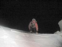
However, it was that short summit gully that seemed the most challenging. It felt like 75 feet of 55 degree rime ice and having a second tool was definitely comforting.

jpsmyth

jpsmyth - May 16, 2011 2:28 am - Hasn't voted

Re: Following Footsteps:

Looking forward to your video. Glad you had as good a time as we did.

ExcitableBoy

ExcitableBoy - May 17, 2011 10:57 am - Hasn't voted

Re: Following Footsteps:

I recall the summit gulley rime chimney/gulley, but I also recall a longer, but easier way to the summit pinnacle?

Holk

Holk - May 17, 2011 11:26 pm - Voted 10/10

Re: Following Footsteps:

I was just after whatever I could get that wasn't within the psychotic wind's grasp and could have easily missed an easier route up the summit.
Did I?
Because descending that chimney/gully was probably one of the most intense things I've done climbing - that is, it was mad freaky fun - although had I known of a different route I'm certain I would've taken it!

jpsmyth

jpsmyth - May 19, 2011 6:23 pm - Hasn't voted

Re: Following Footsteps:

Where was the summit gully? Is it shown on the picture/route you posted the URL to?

Holk

Holk - May 28, 2011 9:41 pm - Voted 10/10

Re: Following Footsteps:

No, I'm referring to the summit pinnacle.

There was a very steep, narrow chute/chimney on its west face that I climbed. I've since realized that had I gone around to the backside/northside of the pinnacle I could have walked onto the summit. I guess that's what I get for being alone and deliriously tired, but It was an extremely fun chute nevertheless.

jpsmyth

jpsmyth - May 28, 2011 11:49 pm - Hasn't voted

Re: Following Footsteps:

I guess we missed that part.

Bascuela

Bascuela - May 16, 2011 5:19 pm - Voted 10/10

Meet you two up top...

My buddy and chatted with you two briefly, near the sulfur vents on your way down. Very nice trip report - think I'll add the Casaval Ridge to my list of things to do!
Aaron

jpsmyth

jpsmyth - May 16, 2011 5:40 pm - Hasn't voted

Re: Meet you two up top...

Thanks! I remember you both. I trust you both had a great climb as well.

ExcitableBoy

ExcitableBoy - May 17, 2011 10:55 am - Hasn't voted
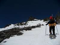
42 degrees

I distinctly remember one short section of neve that I guessed was 45 degrees. There was a minor rock rib on our left and the section ended at the ridge crest. Does this sound like the 'wineglass'? Kind of weird for the ranger to state such a definitive number. I would think the steepness would change based on snowfall, time of season, etc.

jpsmyth

jpsmyth - May 17, 2011 1:09 pm - Hasn't voted

Re: 42 degrees

What you describe as "minor rock rib..." sounds like the steep part I described in my TR. If you click through on the route map link, our short, particularly steep, portion was between 11,600 and 11,800. Not the whole section, but based on time and GPS,within that section. Its where the line jogs almost horizontal towards the ridge line. I don't think what you described sounds like the wineglass. The wineglass was higher up, a little below the catwalks. The top of the wineglass doesn't open up on the ridgeline.

jpsmyth

jpsmyth - May 17, 2011 1:26 pm - Hasn't voted

Re: 42 degrees

Also, what I referred to as the wineglass (I'm pretty sure that's how the ranger referred to it) seems to be called the "hourglass" by others. I agree with you regarding the ranger's specificity around the angle of slope, but overall his briefing was very helpful regarding what to expect. However, what he called the steepest section did not feel as steep as what we perceived to be the steepest section.

Vitaliy M.

Vitaliy M. - May 17, 2011 6:38 pm - Voted 10/10

Hourglass?

http://www.summitpost.org/on-casaval/621593
Is this the spot you are talking about?

jpsmyth

jpsmyth - May 18, 2011 12:31 am - Hasn't voted

Re: Hourglass?

Cculd be but not sure. This picture shows the hourglass (what I was told is called the wine glass). It's right above the red x. I believe I went up the gully to the right and my partner went up the gully above the x.

http://www.summitpost.org/casaval-routes/204288/c-155538

ExcitableBoy

ExcitableBoy - May 18, 2011 11:15 am - Hasn't voted

Re: Hourglass?

Above 11k, we stayed farther climber's right than any of the routes depicted. We hugged the rocky spine of the ridge crest as much as possible. I recall being able to peak my head over crest and watch the headlights on Avy Gulch. Know I know why the Wine/hourglass didn't ring a bell, I was climber's right of it.

ExcitableBoy

ExcitableBoy - May 18, 2011 11:18 am - Hasn't voted

Re: Hourglass?

Wow, now it makes complete sense. As I was downclimbing the West Face, I went skier's left too early and met a roped party climbing up. They said they were on CR, but they were far to climber's left of my line of ascent.

jpsmyth

jpsmyth - May 18, 2011 12:33 pm - Hasn't voted

Re: Hourglass?

We were pretty tight to the top of the ridgeline as well. We veered lower on the west side of ridgeline at around 12,800. This must be where the wineglass/hourglass is. If you look at the map link you can see our path along the ridgeline up to 12,800. Where the path angles more NE above 12,800 is where our GPS tracker cut out (we didn't traverse on the east side of the ridge).

ExcitableBoy

ExcitableBoy - May 18, 2011 1:18 pm - Hasn't voted

Re: Hourglass?

I'm having a little difficulty reconciling the photo with the route variations and the map with your actual GPS track. Would you say your GPS track (actual line of ascent) lies climber's right of the routes indicated on the map?

Viewing: 1-20 of 32
12

Table of Contents