
|
|
Mountain/Rock |
|---|---|
|
|
38.88860°N / 119.5025°W |
|
|
Douglas |
|
|
Hiking |
|
|
Spring, Fall |
|
|
9451 ft / 2881 m |
|
|
Overview
Galena Peak 9416’ and Mount Siegel 9451’ are the highest peaks in the Pine Nut Mountains. They warrant a shared page because Galena Peak is technically a sub-summit of nearby Mount Siegel (Galena Peak rises less than 200’ above the saddle it shares with Mount Siegel).
These mountains are located approximately 25 miles southeast of Carson City in Douglas County. Although these are prominent summits, they are not climbed very often. That is because most people choose to hike the Sierras, and there aren’t any trailheads up these mountains, or major trails. Rather, jeep roads head up the slope to the lofty summits. Another issue is that access is tricky from either side of the range.
Interestingly, Galena and Siegel are actually higher than many of the prominent summits around Lake Tahoe. In fact, Mount Siegel would be the Douglas County highpoint if it weren't for East Peak 9591', which is located in the Sierra Nevada within the Heavenly Ski Area being just within Nevada. So one might say that Mount Siegel is the highest mountain in Douglas County located outside of the Sierra Nevada. It is officially the second highest in Douglas County, Nevada.
From the west, Pine Nut Road heads east of Highway 395 towards the base of the mountains. Once the road hits about 5700 feet, dirt roads follow the rest of the way up the north side of the peak, and road conditions are not suitable for 2WD. A 4WD is recommended.
From the east, access also requires 4WD via Red Canyon Road leaves from the pavement and heads directly into the heart of mountains. The summit of Mount Siegel can be reached by hiking up 5 miles of mostly jeep trail.
Summit views on a clear day can reach over 100 miles. The Sierras lie to the West, while numerous Nevada desert peaks can be viewed to the East.
It is best to hike these peaks between April and June, and October and early December. These ridges can be intensely windy, so be mindful of weather forecasts. It is often too hot and too dry to hike here during the summer.
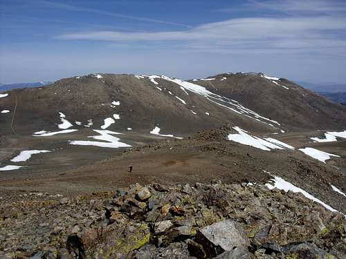
Galena Peak (left) and Mount Siegel (right) viewed from Oreana Peak 9346'
Getting There
From Reno, Nevada, follow 395 South through Gardnerville. If approaching from the west, take Pine Nut Road, accessible at the south end of the town.Take it for 6 ½ miles and the road forks. Take the left fork on Slater Mine Road whichturns into Lone Pine Canyon Road and heads up to a saddle north of Galena andSiegel.
If approaching from the east continue about 16 miles further south on 395 to Nevada State Route 208E. Follow Route 208E for about 9.5 miles to Upper Colony Road. Follow that north for 4.4 miles to Pinon Drive on the left. After 0.8 miles turn left at Day Lane, and then take the first right onto Red Canyon Road. Follow it for about 4 miles and park at a turnabout on the left side of the road at about 6500 feet. There are no other good parking areas further up.
Road ratings
Although the road is smooth initially, it gets pretty rough after the first mile. A high clearance, 4WD is highly recommended. In terms of ratings, the road ranges between a 1 rating and a 4 rating (See Scott Surgent's page regarding the road rating system). In general, the road starts as a 1 rating, quickly turns into a 2 rating, then becomes a 3 and 4 rating after the first mile. The road is also very narrow; only enough for one 4WD vehicle. So, if you encounter another 4WD, you may have some trouble. There are few places to move over to the side.
Route Information
From the East: Red Canyon RoadFrom the unmarked parking area on Red Canyon Road, the elevation is about 6500’. An SUV can usually make it this far. Follow the road until you see a jeep trail that heads up the slope to the right, winding up to a ridge into a forested area. Follow the road as it heads up to an open slope towards Oreana Peak 9346’. Pass Oreana Peak, and continue for about 2 miles to the summit of Mount Siegel, or head up the road to Galena Peak and cross over the ridge to Mount Siegel (recommended). The entire hike from the parking area this way is about 10 1/2 miles. Add another ¾ miles for a side trip to Oreana Peak.
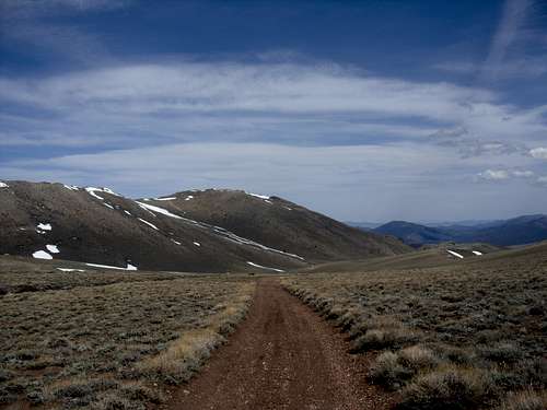
Dirt Road heading towards Mount Siegel
If only hiking Galena and Mount Siegel, there is another option. The mining road to the south of the granite wall. After about 3/4 miles from the parking area there is a fork in road. To the right is the route up to Oreana Peak. To the left is a road leading up to an old mining area. That road heads all the way up to the base of Galena Peak. Using this road, it is 5 miles one way to reach both Galena Peak and Mountain Siegel. Elevation gain to Mount Siegel is about 3,000'.
From the West: Lone Pine Canyon
Pine Nut Road heads to the right, while Slater Mine Road heads straight east. Follow Slater Mine Road, until it becomes Lone Pine Canyon Road. Follow this as far as possible (likely 2 miles). A 4WD high clearance is needed to get the up the Lone Pine Canyon Road. After about 2 miles, the 6,000 foot level is reached. If you can’t take the road further, it is time to start hiking up the road, which heads to the left of the summit ridge of Mount Siegel. It takes at least 3-3.5 miles on the road to get to a point where you can head up to the summit ridge. Once atop the trees on the summit ridge head up the slope (going south) for 2 miles to the summit of Mount Siegel. Galena Peak is another ¾ miles away. This can probably be done in 12 miles round trip with some bushwhacking up the summit ridge. Oreana Peak 9346’ is about 2 miles further. Overall, adding Oreana Peak requires at least 14 miles of round trip hiking.
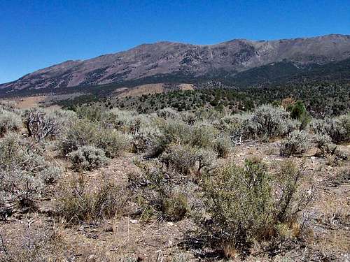
Mount Siegel viewed from the southwest