
-
 12835 Hits
-
 82.2% Score
-
 15 Votes
|
|
Mountain/Rock |
|---|---|
|
|
42.81360°N / 109.2558°W |
|
|
Scrambling |
|
|
Summer |
|
|
12524 ft / 3817 m |
|
|
Overview
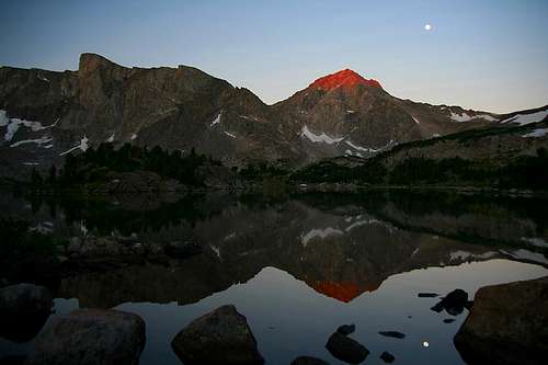
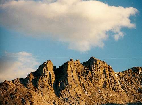
Dawn light striking Mount Washakie, reflected in its namesake lake. By Nelson.
The climbers that flock to the Winds don't come for peaks like Washakie, but it is a good mountain that is worth climbing. It offers a Class 3 route, views of some of the wildest country in the Winds, and solitude far from roads. Nevertheless, it is easily approachable from good trails that climb to a high passe.
Consider these factors that Washakie has going for it:
•It is on the Continental Divide.
•It is deep in a spectacular wilderness area.
•It is a fun Class 3 trip that affords outstanding views and sees little traffic.
•It is a monumental peak in its section of the Winds.
•It is a fine alternative to the more heavily used areas of the range and delivers typically epic High Winds scenery.
•It is a relatively safe introduction to the great rock of the Wind River Range.
I climbed this peak in 2001, well before I discovered SummitPost, and that means I took photos not of routes and all the summit views but instead of what I found most pleasing to my eye with the few shots I had left on my last roll of film. And in retrospect, I kick myself for tossing two summit views-- one north along the crest of the Winds all the way to the biggest of its peaks, the other south showing a unique and interesting perspective of Texas Lake and the Cirque of the Towers. Both photos were decent but not worth keeping in an album of my best shots, and now both the photos and the negatives have gone to photography heaven (or hell).
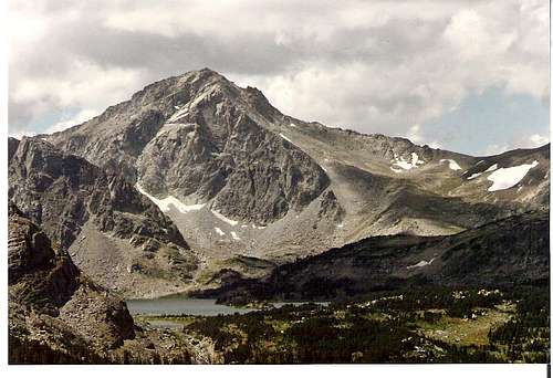
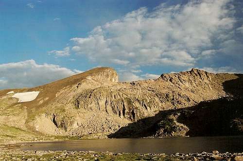
Mount Washakie from the Bear's Ears Trail; the ridgeline on the right is the climbing route-- by Tracy
Getting There
Before heading out, drivers may want to stop at a convenience store and buy a Wyoming recreation map. Another good resource to have is the Wyoming Atlas and Gazetteer.Access to the Bears Ears Trail seems to have gotten sticky in the years since I hiked it-- lucky for me but not for anyone who’s had to deal with the frustration of these issues. If the access is open, though, take the Bear’s Ears Route, which is longer and harder than the alternative but is less crowded and incredibly scenic.
The latest news, as of August 2007, is that the road is open again but that users have to purchase the reservation fishing permit to drive the road.
Drive south on U.S. 287 from Fort Washakie, on the Wind River Indian Reservation, a mile past the Wind River Agency and just north of a trading post and store. There may be a sign for Trout Creek Road. This is the road you want. Drive west for about 5 miles and bear right on a gravel road for Moccasin Lake. Bear right again when a spur road branches off in about 0.3 mi. Now the road starts climbing steeply and becomes narrower and rockier. Still, most passenger cars should get you to the trailhead.
When the road meets the Moccasin Lake Road after about 19 miles, bear left for Dickinson Park. In less than a mile, the road enters Shoshone National Forest. You are safe now unless someone gates the road behind you, and this has happened. Almost 21 miles from U.S. 287, take a signed spur road (right) to the Bears Ears Trailhead. The road gets pretty rough and rutted now, but careful drivers can make it the half-mile or so from the main road to the trailhead.
Big Sandy-- An alternate, easier, but busier approach to Washakie Pass is via the popular Big Sandy area. The drive to the TH may be the crux of this route because it is so long and parts are rough. Reaching the trailhead for the extremely popular Big Sandy area (it is the main TH for the famous Cirque of the Towers) requires a long drive, but there aren’t any access issues. Because there are several ways to get to Big Sandy, requiring so many details, I will just describe the one used most often, which is the approach from Pinedale.
Drive to Boulder, which is 11 miles south of Pinedale on U.S. 191, and then take WY 353 east. The pavement ends after 18 miles, and less than a mile after that, bear left at a junction (the right turn takes you back to 191). Almost 3 miles later, bear right at another junction (left goes to the Muddy Feedground). When you are a little more than 27 miles from Boulder, there will be another junction, where you turn left. A sign should be there indicating that right goes to Farson and left to Big Sandy.
The high desert and ranch country you have been passing through now open up to reveal views of the Wind River Range. 32 miles from Boulder, another signed junction will steer you left; right takes you to WY 28 and South Pass directly across from Oregon Buttes Road, a major access point to the Great Divide Basin.
Follow signs to the Big Sandy TH and campground. They are about 11 miles from the Big Sandy/South Pass junction mentioned above.
The last few miles to the TH are rough and rocky, but most passenger cars can make the trip. I have found the rest of the road system, every time I have driven it (2001, 2004, 2007) to be very easy going (when dry) and not at all rough and washboarded as some descriptions put it. The biggest danger, in fact, is going TOO fast on these roads and losing traction. Keep at 25-35 mph.
Route
Approach from Bears Ears TH: The trail quickly climbs past timberline, gaining almost 2800’ in eight miles to its crest at 12,000’ a little past Mount Chauvenet, where the trail bends south and then west again as it descends 2000’ to the South Fork Little Wind River and a junction with the Washakie Trail. Almost half the Bears Ears Trail crosses open tundra, and there is little or no shelter available. Start early in the morning, or watch the sky carefully if you start in the afternoon.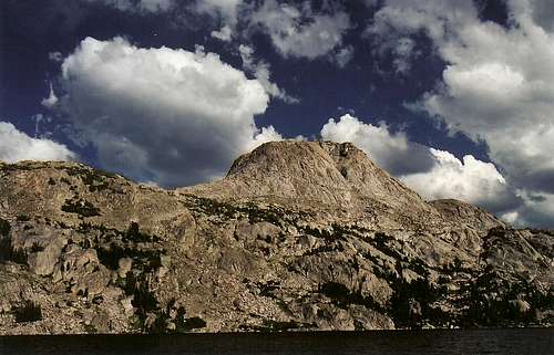
Valentine Lake
Pass a junction with the Lizard Head Trail (long access to the Cirque of the Towers) at 8.8 miles. Scenic and popular Valentine Lake is at 11 miles. The trail bottoms out and meets the Washakie Trail at about 12.5 miles. Fording the South Fork Little Wind River is necessary and could be dangerous early in the summer.
Payson Peak and South Fork Little Wind River
The Washakie Trail climbs to 11,611’ Washakie Pass on the Continental Divide in 3.5 miles. There may be steep snow to cross just below the pass. The pass is where you access climbing routes for Washakie and Bernard.
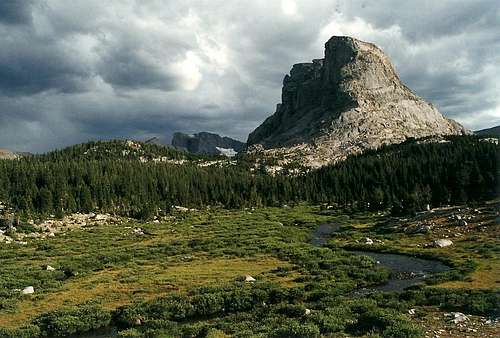
Along the Washakie Trail
Along the Washakie Trail-- Bernard Peak and Macon Lake
Approach from Big Sandy: The hiking route itself climbs about 2500’ to Washakie Pass in 11.6 miles via the Fremont Trail and the Washakie Trail. Once you are a few miles from Big Sandy, crowds will almost certainly thin out dramatically, and the trail over Washakie Pass is rated as lightly trafficked. So is Hailey Pass a little to the north, another great destination if you are spending a few nights out here. Don’t miss the Class 3 climb of Pyramid Peak from Hailey Pass for an awesome perspective of the Hooker and Bonneville areas.
Climbing: Washakie has a Class 3 route on good rock with some exposure, a bit of it quite impressive. Just head south from Washakie Pass and follow the ridgeline as closely as possible. If you have to detour, detour west (right) when possible, and you will avoid the exposure, but also the great views of the Washakie Glacier and Pass Lake. Weigh the pros and cons and make your choice, or try a little of both. At the summit, check out the views south of the Cirque of the Towers and smile a little smugly, knowing the many people there have the better climbing but that you have the peace and quiet the high mountains are supposed to offer.
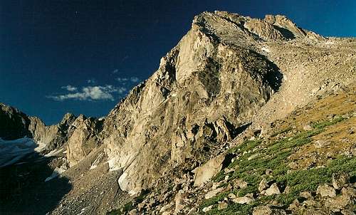
The peak from below Washakie Pass
You will probably have the summit to yourself.
After the climb, consider the Class 2 ramble up Bernard Peak, which is just north of Washakie Pass.
A Side Trip to South Fork Lakes
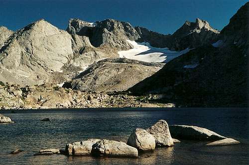
Lower Lake
From my campsite, I could see some snowy peaks south beyond Payson Peak, and a look at my map told me I could find the South Fork Lakes up there. There are no established trails to this beautiful alpine basin, but there is a use trail from Valentine Lake. Going back up there from my camp was impractical, though, so I crossed the river and followed a steeply cascading stream all the way up to the lower lake, from which it was easy to reach the upper lake. South Fork Lakes was one of the most astounding places I have ever seen, and it may have been my favorite place in the Winds during my forays into them that summer. It was worth the slippery bushwhacking up the stream from my camp, and it was a great late-afternoon jaunt following an exciting morning out at Hailey Pass, Pyramid Peak, and Baptiste Lake. Don’t miss this place. If I ever go back, I’ll see if I can climb some of the surrounding peaks, which look wonderful.
Red Tape
Access issues have been a problem in the Dickinson Park area in recent years, and it may be easier to approach from Big Sandy. Currently, a Reservation fishing permit is required for driving the road to Dickinson Park. Here is a PDF showing the fees and regulations as of 2011. To make sure you are aware of the current fees and regulations, you are advised to use this contact information:Shoshone & Arapaho Tribes
Fish and Game Department
PO Box 217
Fort Washakie, WY 82514
307-332-7207
Currently, hiking and camping permits aren’t required in the rest of the Winds, but voluntary self-registration is a good idea. Don’t go alone unless you have to. I had to.
Grizzlies have returned to the northern Winds and will probably spread south. This is a good thing, but know proper bear-country etiquette. Black bears are abundant and have been troublesome in some of the popular backcountry areas, so store food properly, don’t cook in what you sleep in, don’t chase cubs around, etc.
Camping
Camping is available at small Dickinson Creek Campground (a bit south of the turnoff for the Bear’s Ears trailhead) and at Big Sandy. You can probably car camp at the trailheads, too. Backcountry camping is, of course, abundant and delightful. My camp on a ledge over the South Fork Little Wind River was one of the greatest campsites I have ever found. Valentine Lake has many campsites, but it’s worth the extra hiking to find the solitude of the river valley below it. Plus, your day trips to the peaks and passes nearby will be shorter and easier. Avoid camping (and walking) on the tundra unless nightfall or emergency conditions make you.External Links
Next to USGS quads, the best maps I have seen for the range are those published by Earthwalk Press. These maps have the following advantages over the USGS quads: two fold-out maps cover the entire range, wilderness regulations and precautionary information are on the maps, and the maps are waterproof.Of great help planning excursions in the Winds is Hiking Wyoming's Wind River Range. The book has almost no climbing information, but that is not its purpose. Instead, it has detailed route descriptions with good directions, elevation profiles, and distances. Some customer reviewers complained about the poor maps, but anyone relying on a guidebook's maps for trip planning and actual hiking is probably a fool, anyway. Get the Earthwalk Press maps and this book and start trip planning.
If approaching from Bears Ears TH, it would be smart to contact Shoshone National Forest
(307-578-1200, 307-527-6241) first about current conditions and access issues.
If approaching via Big Sandy, the agency to contact is Bridger-Teton National Forest
(307-739-5500).