
|
|
Mountain/Rock |
|---|---|
|
|
48.70250°N / 118.4642°W |
|
|
Ferry |
|
|
7140 ft / 2176 m |
|
|
Overview
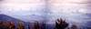
 Paul Klenke's nice pic of Copper Butte
The Kettle Mountain range in north eastern Washington is little known outside of the local area. Generally, when people think of Washington State, they think of mountains like Mt. Rainier and Mt. Baker and rightly so. However, hidden away in the northeastern part of the state is a lot of interesting country that has a lot less population pressure on it and you can find solitude when the other areas are packed elbow to elbow.
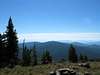
Copper Butte, while no Mt. Rainier, is the highest peak in the Kettle Range and the highest point in Ferry county. It is not a mountain with mountaineering challenge and a trail leads to the top where a lookout once stood but it is in an area of historical significance. Views from the summit look north into Canada and west on a clear day you can see the Norh Cascades.
Another interesting note is that this unheralded peak ranks #10 on the Washington prominence list. It has 4,740'+ of prominence
This peak also has interest to those who chase county highpoints since it is the highest in Ferry county

Getting There
From Kettle Falls, drive west on US 395. After crossing the Columbia River, turn left just after the bridge onto SR 20 which heads towards Sherman Pass on what is also called the Sherman Pass byway It is about 18.5 miles to the crest of Sherman Pass and watch for Albion Hill road #2030 and turn right onto it. Head north on FR 2030. At 0.6 mile, keep right. At 3.4 miles, pass the signed Wapaloosie trailhead; at 3.7 and 3.8 miles keep left at forks signed "S. Deadman". Stay on the main road past various unmarked spurs. At 7.4 miles you'll find the signed "Old State" trailhead on your left. Turn left, cross the cattle guard, and park at the turnaround loop / trailhead sign in the trees about 0.1 mile off the main road. There is a modern forest service restroom (outhouse type) for your convenience.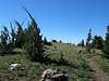 |  |  |  |  |
Red Tape
The has information available but I don't recall seeing a sign requiring a NW Forest Pass. If anyone has updated information, please add it to the comments.When To go and do the hike
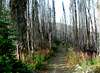
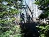
The main concern would be when the road is snow free. Snowmobilers can access the area but for most of us, it will be necessary to wait until the road is open. There is no real "climbing" involved in getting to the top of this peak as it is a walk up via a nice trail. A benchmark is located just a short distance from the cairnFor a trail description, see the Old Stage Road route at the left.
The best time to do this hike is probably June - October
More information can most likely be obtained from the Colville Ranger Station
765 South Main Street Colville, WA 99114
(509) 684-7000
 |  |  |  |  |
Camping
You can actually camp at the TH area. This is a nice area to camp with fire pits as well as a decent FS vault toilet facility. No water available so you'll need to bring your own.Motel facilities are available in Kettle Falls and additional camping possibiities can be found near Sherman Pass.
Historical significance
In reading the sign, I found out a lot of interesting information about not only the area but how the trail being used came into existence. The memorial at the summit is a mystery to me as to why Copper Butte was chosen for this honor. Anyone out there know?If you have information about this mountain that doesn't pertain to any of the other sections, please add it here.
 |  |  |  |
Other peaks / mtns of the Kettle Range
Copper Butte is the highest of the Kettle Range Peaks but there are many others that are fun to climb that are nearly as high:Snow Peak 7103
Scar Mtn 7046
Wapaloosie Mtn 7018
Sherman Peak 7011
Bald Mtn 6940
White Mtn 6921
Columbia Mtn 6782
Midnight Mtn 6660
King Mtn 6634
Jungle Hill 6544
Barnaby Butte 6534
Lambert Mtn 6525
Mt. Leona 6474
Profanity Peak 6423
Midnight Mtn is just very close to Copper Butte and can be done as a sidehike but Profanity Peak was named for a special reason which would be interesting to know of. Sherman Peak is right next to Sherman Pass but this gives you most of the names and elevations of the important Kettle Range peaks. You could easily spend a fun week of camping and hiking in this area.
 |  |
Mountain Conditions and weather
Since the weather link to time/temperature seems to be down alot lately, click HERE for the weather report for Kettle Falls, the nearest townSherman Pass has a weather cam that gives a view of the pass area and conditions.
USGS Topo Map: Copper Butte
Views From the Mountain
 |  |  |  |  |
Ferry County Washington
Since Copper Butte is the county highpoint, it would be nice to know about more about the county itself. So, thanks to Wikipedia, I have assembled the following information:As of 2000, the population was 7,260. The county seat is at Republic, which is also the county's largest city. It was named after Elisha P. Ferry, the state's first governor. Ferry County was created out of Stevens County on February 21, 1899.
External Links
- Copper Butte Listing on TrailsNW.com
Detailed trail description and photos of Copper Butte, WA.
---------------------------------------------
Great resource with two maps: Peakbagger