
-
 30278 Hits
-
 86.85% Score
-
 23 Votes
|
|
Mountain/Rock |
|---|---|
|
|
46.49290°N / 121.422°W |
|
|
8000 ft / 2438 m |
|
|
Overview
Big Horn is the unofficial name given to the second highest point on the ridge west of Gilbert Peak. It is just west of the highest point on the ridge, called Goat Citadel. Big Horn is the highpoint of Lewis County. According to John Roper, the only person to have completed all of the county highpoints in Washington until July 2004, the most difficult pitch on the easiest routes of Washington's county highpoints is the 10-foot vertical crack near Big Horn's summit. Beckey rates the move a difficult class 4. Our party was inclined to agree with the 5.4 rating given by Roper in his trip report. |  |  | 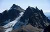 |  |
Getting There
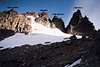
Take I-5 north from Portland or south from Olympia to exit 68, then head east on US Highway 12 toward Packwood. Just after milepost 128 turn right onto Forest Service road #21 (Walupt Lk, Chambers Lake). This turn off is about 2.5 miles before Packwood. After 13.5 miles on this gravel road turn left onto FR 2150 (Snowgrass Trail #96, Chambers Lake) In a little over a mile turn left again following the signs to Snowgrass Flat. The TH parking area is at 4,600 feet. Take trail #96A a short distance to where it connects to trail #96, then hike east on 96. At 3.7 miles turn right on Bypass Trail #97. There are nice camps near a great stream soon after the junction. Continue east on 97 until it reaches the Pacific Crest Trail. Take the PCT southbound toward Cispus Pass. Where the trail turns north into Cispus Basin, there is a great view of Big Horn off to the right a few yards. The trail then traverses into Cispus Basin.Leave the trail where it crosses the headwaters of the Cispus River that drains the broad slopes below the cliffs. Ascend to the saddle just southwest of "Black Thumb", traverse under the cliffs east of the saddle, then ascend the loose gullies and ribs to the small basin east of Big Horn, south of Little Horn, and west of Goat Citadel. From this vantage point we chose a route up the east face of Big Horn's south ridge. We started in the right-hand gully a short distance, then traversed on an obvious ledge to the left-hand gully, then climbed it to the top of the ridge. Then we climbed the ridge itself, negotiated the 10-foot vertical crack, and scrambled to the summit.
 |  |  |  |  |
Red Tape
Most trails and some picnic areas and campsites in the Gifford Pinchot National Forest require a regional pass costing $5/day or $30/year. Interagency Senior Pass holders may access most federal recreational facilities, including the trailheads in this region, free of charge. Golden Age and Golden Access Passport holders may purchase the pass at a 50% discount.Big Horn is within the Goat Rocks Wilderness. A free wilderness permit is available at the trailhead.
When To Climb
Big Horn is best climbed from June through September. | 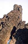 |
Camping
With the mandatory wilderness permit, camping is permitted in the Goat Rocks Wilderness. There are numerous car camping opportunities in the Gifford Pinchot National Forest nearby.Mountain Conditions
For additional information you may contact:Gifford Pinchot National Forest
10600 N.E. 51st Circle
Vancouver, WA 98682
Voice: 360-891-5000
24-Hour Recording: 360-891-5009
Brian Jenkins - Aug 12, 2011 2:43 pm - Hasn't voted
linksHey Bob, Your links in Red Tape and Mountain Conditions are no longer working. Brian