
-
 48161 Hits
-
 91.14% Score
-
 34 Votes
|
|
Mountain/Rock |
|---|---|
|
|
39.79600°N / 105.854°W |
|
|
12947 ft / 3946 m |
|
|
Vasquez Mountains Overview
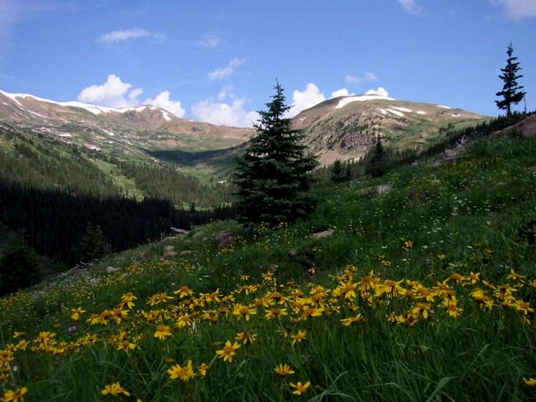
A patch of Coneflowers before the upper drainage of the West Fork of Clear Creek, seen from the slopes of Vasquez Peak.
 The Vasquez Mountains are an indistinct subrange of Colorado's Front Range. Extending from Berthoud Pass and the Fraser River Valley on the east, to the Williams Fork River on the west, and then north to Bottle Peak, they are a small L shaped range. The summits of the Vasquez Mountains are generaly in the twelve thousand foot range. Although the terrain of these mountains consists of much rolling tundra; glaciation has carved some impressive cirques in the eastern aspects of many of the ridges and mountains in the area. The Vasquez Mountains are home to two of Colorado's wilderness areas: the Vasquez Peak Wilderness in the south and the Byers Peak Wilderness in the north. The intervening Fraser Experimental Forest lends a deep wilderness feel to these mountains as the forest seperates the summits from civilization with a thick blanket of Engleman Spruce and Lodgepole Pine.
Although less dramatic then the nearby Indian Peaks and Gore Range, of which they offer superb vantages, the Vasquez Mountains offer a quite and intimate mountain experience. An extensive trail system offers excellent acess to these mountains: The Continental Divide Trail follows the southern slopes of these mountains, the Mount Nystrom Trail enters the heart of the Vasquez Peak Wilderness, and the St. Luis Divide Trail links the Byers Peak Wilderness with the Vasquez Peak Wilderness.
The named Vasquez Mountains are (from north to south, then west to east): Bottle Peak (11,584 ft), (Byers Peak (12,804 ft), Bills Peak (12,703 ft), St. Luis Peak (12,246 ft), Mount Nystrom (12,652 ft), Vasquez Peak (12,947 ft), and Stanley Mountain (12,521 ft).
 |
 |
 |
 |
 |
Vasquez Peak Overview
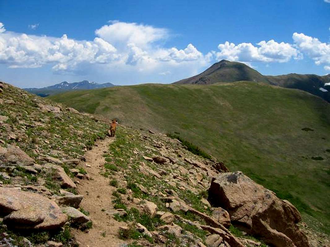
Vasquez Peak from the Continental Divide Trail. July 2005.
Vasquez Peak is the highpoint of the Vasquez Mountains. Its gentle summit sits astride the Continental Divide between Clear Creek County and Grand County. The name honors Louis Vasquez, a french trapper and hunter who explored this section of Colorado, and was one of the first European settlers of what would become Clear Creak County.
Vasquez Peak is most remarkable for the views it offers. From a sweeping vista of the Gore Range to an interesting view of Pettingell Peak and its attendent summits, to a vantage of the Grays and Torreys and the Evans Massif, to the gentle sweep of the James Peak Wilderness, to the jagged extent of the Indian Peaks rising toward Longs Peak; Vasquez Peak offers three hundred and sixty degrees of splendor.
Physicaly Vasquez Peak is a rounded mountain that is dificult to see from the nearby valleys. It rises over 500 feet from nearby Vasquez Pass and is higher then any of the surrounding summits; yet its prominence isn't apparent from below. On top of Vasquez Peak it is apparent that you are on the highest mountain in the vicinity. Vasquez Peak has a 12,900 ft tall sub-summit that is a fine companion peak for this mountain. The stroll between the sub-summit and the main summit is a fine place to stretch ones legs and see countless wildflowers during the summer months. Although alpine tundra and grasses cover the slopes the summit region itself does have a small rock outcrop. The geology of Vasquez Peak is typical of the Front Range; the mountian is composed of Idaho Spings Formation granites, schists, and gniesis; Colorado's basement rock hoisted high. It is part of a small anticline that makes up the Vasquez Mountains.
The section of the Continental Divide trail that skirts Vasquez Peak is one of more scenic sections of the trail the author has experienced. Indeed when I climbed Vasquez Peak my expectations were quite low. What could a little mountain so close to the noise and bustle of an extensive mine complex offer? It offers a subdued beauty that is that much more remarkable for its obscurity and proximity to the toil of civilization.
 |
 |
 |
 |
 |
The Wildflowers of Vasquez Peak
Part of the allure of Vasquez Peak is the extensive wildflowers of the summer months. On the grassy slopes of Vasquez Peak I have seen: Pink Pussytoes, Whooly Actinella, Tall Chimming Bells, Little Elephantheads, Heart-Leaved Arnica, Colorado Columbines, Scarlet Paintbrush, Rosy Paintbrush, Indian Paintbrush, White Bog Orchids, Tall Penstemon, Sun Loving Asters, Kings Crown, Coneflowers, Harebells, and Purple Fringe. The ascent of this mountain makes for a wonderful wildflower clinic.
 |
 |
 |
 |
 |
Getting There
Follow US-40 for 9.6 miles from the junction with I-70. Just before US-40 begins climbing toward Berthoud Pass there is a sharp turn with a sign for the Henderson Mine. Turn here and follow this road 1.75 miles to the Henderson Mine. Continue on a dirt road on the right side to a sizable parking area 0.5 miles further. Park. The dirt road continues on to the west towards Jones Pass. Several routes can be taken from here to ascend Vasquez Peak which lies almost directly north.
 |
Red Tape
No Permits required. Avoid irking the Henderson Mine Company by blocking roads etc... The Henderson Mine provides the road and the parking for the trailheads. Try not to begrudge them as this is much more then many private or corporate entities are willing to do in Colorado.
Away from the mine this mountain lies within the jurisdiction of the Clear Creek Ranger District to the south and the Sulpher Ranger District to the north.
Clear Creek Ranger District
101 Chicago Creek, Box 3307
Idaho Springs, CO 80452
303-567-2901
Sulpher Ranger District
9 Ten Mile Drive
Granby, CO 80446
970-887-4100
When To Climb
This mountain could be ascended year round. The Henderson Mine road provides plowed access throughout the winter months. HOWEVER avalanche terrain is encountered above timbeline and should be avoided in the off seasons. A long ridge route following Vasquez Peak's west ridge may mitigate the danger somewhat but caution is suggested.
 |
Camping
Car camping is a possibility along the Jones Pass Road. Backpacking camping spots are found along the Continental Divide Trail.
Mountain Conditions
